Local government areas of Tasmania
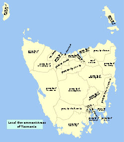
Local government areas (LGAs) in the Australian state of Tasmania describes the 29 organisations and processes by which towns and districts can manage their own affairs. The LGAs are grouped by region.
This article also includes lists of towns, suburbs and localities of Tasmania.
Local government areas
| Local government area | Principal town | Date established | Land area[1] | Population.[2] (2015) |
Density | Region | |
|---|---|---|---|---|---|---|---|
| km² | sq mi | ||||||
| Break O'Day | St Helens | 3,525.8 | 1,361 | 6,469 | 1.8 | North-east | |
| Brighton | Brighton | 171.3 | 66 | 16,010 | 93.5 | Hobart | |
| Central Coast | Ulverstone | 933.1 | 360 | 22,401 | 24 | North-west and west coast | |
| Central Highlands | Hamilton | 7,982.4 | 3,082 | 2,309 | 0.3 | Central | |
| Circular Head | Smithton | 4,897.7 | 1,891 | 8,245 | 1.7 | North-west and west coast | |
| Burnie City | Burnie | 611.0 | 236 | 19,887 | 32.5 | North-west and west coast | |
| Clarence City | Rosny Park | 1860 (Municipality)[3] 1988 (City)[4] | 378.0 | 146 | 54,674 | 144.6 | Hobart |
| Devonport City | Devonport | 111.3 | 43 | 25,533 | 229.4 | North-west and west coast | |
| Glenorchy City | Glenorchy | 1864 (Municipality) 1964 (City)[4] | 121.1 | 47 | 45,827 | 378.4 | Hobart |
| Hobart City | Hobart | 1835[5] | 77.9 | 30 | 50,714 | 651 | Hobart |
| Launceston City | Launceston | 1857[5] | 1,413.6 | 546 | 67,078 | 45.4 | Launceston |
| Derwent Valley | New Norfolk | 4,108.1 | 1,586 | 10,026 | 2.4 | South-east | |
| Dorset | Scottsdale | 3,227.6 | 1,246 | 7,105 | 2.2 | North-east | |
| Flinders | Whitemark | 1,996.6 | 771 | 783 | 0.4 | North-east | |
| George Town | George Town | 653.4 | 252 | 6,802 | 10.4 | Launceston | |
| Glamorgan Spring Bay | Triabunna | 2,591.4 | 1,001 | 4,493 | 1.7 | South-east | |
| Huon Valley | Huonville | 5,507.4 | 2,126 | 16,354 | 3.0 | South-east | |
| Kentish | Sheffield | 1,156 | 446 | 6,481 | 5.6 | North-west and west coast | |
| King Island | Currie | 1,095.8 | 423 | 1,566 | 1.4 | North-west and west coast | |
| Kingborough | Kingston | 720.1 | 278 | 35,833 | 49.8 | Hobart | |
| Latrobe | Latrobe | 600.5 | 232 | 10,938 | 18.2 | North-west and west coast | |
| Meander Valley | Westbury | 1993 | 3,330.3 | 1,286 | 19,686 | 5.9 | Launceston |
| Northern Midlands | Longford | 5,136.5 | 1,983 | 12,749 | 2.4 | Central | |
| Sorell | Sorell | 1862[6] | 583.7 | 225 | 13,955 | 23.9 | South-east |
| Southern Midlands | Oatlands | 2,615.4 | 1,010 | 6,278 | 2.4 | Central | |
| Tasman | Nubeena | 660.5 | 255 | 2,405 | 3.6 | South-east | |
| Waratah-Wynyard | Wynyard | 3,531.0 | 1,363 | 14,289 | 4.0 | North-west and west coast | |
| West Coast | Zeehan | 9,589.8 | 3,703 | 4,483 | 0.7 | North-west and west coast | |
| West Tamar | Beaconsfield | 691.1 | 267 | 23,202 | 33.6 | Launceston | |
| Tasmania | Hobart | 68,018.2 | 26,262 | 516,586 | 7.3 | ||
Current local government areas by region
Hobart area councils
Greater Hobart contains six LGAs:
- Brighton Council, containing the Hobart suburbs of Bridgewater, Gagebrook, Old Beach, and the towns of Brighton, Pontville, and Tea Tree.
- City of Clarence, containing the Hobart suburbs of Acton, Bellerive, Cambridge, Clarendon Vale, Cremorne, Geilston Bay, Howrah, Lauderdale, Lindisfarne, Mornington, Opossum Bay, Otago, Risdon, Risdon Vale, Rokeby, Rose Bay, Rosny, Seven Mile Beach, South Arm, Tranmere, and Warrane; and the town of Richmond.
- City of Glenorchy, containing the Hobart suburbs of Austins Ferry, Berriedale, Chigwell, Claremont, Collinsvale, Derwent Park, Dowsing Point, Glenlusk, Glenorchy, Goodwood, Granton, Lutana, Montrose, Moonah, Rosetta, and West Moonah.
- City of Hobart, containing the Hobart suburbs of Battery Point, Dynnyrne, Fern Tree, Glebe, Hobart, Lenah Valley, Mount Nelson, Mount Stuart, New Town, North Hobart, Ridgeway, Sandy Bay, South Hobart, Tolmans Hill, and West Hobart.
- Kingborough Council, containing the Bruny Island suburbs of Adventure Bay, Alonnah, Apollo Bay, Barnes Bay, Dennes Point, Great Bay, Killora, Lunawanna, North Bruny, Simpsons Bay, and South Bruny; the Hobart suburbs of Blackmans Bay, Bonnet Hill, Howden, Huntingfield, Kingston, Kingston Beach, and Taroona; and the towns of Albion Heights, Allens Rivulet, Coningham, Cradoc, Electrona, Gordon, Kaoota, Kettering, Longley, Lucaston, Lower Longley, Margate, Neika, Oyster Cove, Pelverata, Sandfly, Snug, The Lea, Tinderbox, and Woodstock.
- Sorell Council, containing the towns of Bream Creek, Dodges Ferry, Copping, Dunalley, Kellevie, Lewisham, Marion Bay, Midway Point, and Sorell.
South-east area councils
The south-east area councils contains four LGAs:
- Derwent Valley Council, containing the towns and settlements of Adamsfield, Black Hills, Boyer, Bushy Park, Feilton, Fenton Forest, Fitzgerald, Glenfern, Glenora, Granton, Hayes, Karanja, Lachlan, Lawitta, Macquarie Plains, Magra, Malbina, Maydena, Molesworth, Moogara, Mount Field, Mount Lloyd, National Park, New Norfolk, Plenty, Rosegarland, Sorell Creek, Strathgordon, Tyenna, Upper Plenty, Uxbridge, and Westerway.
- Municipality of Tasman, containing the towns and settlements of Koonya, Murdunna, Nubeena, and Port Arthur.
- Huon Valley Council, containing the towns and settlements of Cygnet, Dover, Franklin, Geeveston, Port Huon, Glen Huon, Huonville, and Southport.
- Glamorgan Spring Bay Council, containing the towns and settlements of Bicheno, Coles Bay, Orford, Swansea, and Triabunna.
North-east area councils
The north-east area councils contain three LGAs:
- Break O'Day Council, containing the towns and settlements of Fingal, St Helens, St Marys, and Scamander.
- Dorset Council, containing the towns and settlements of Branxholm, Bridport, Derby, Scottsdale, and Winnaleah.
- Flinders Council, containing Cape Barren Island and Flinders Island and its settlements of Emita and Whitemark.
Launceston area councils
The Launceston area councils contain four LGAs:
- George Town Council, containing the towns and settlements of Bell Bay and George Town.
- City of Launceston, containing the Launceston suburbs of East Launceston, Invermay, Kings Meadows, Launceston, Mayfield, Mowbray, Newnham, Newstead, Norwood, Punchbowl, Ravenswood, Rocherlea, South Launceston, St Leonards, Summerhill, Trevallyn, Waverley, West Launceston, and Youngtown; and the towns and settlements of Dilston, Lilydale, Relbia, and Windermere.
- Meander Valley Council, containing the Launceston suburbs of Blackstone Heights and Prospect; the towns and settlements of Carrick, Deloraine, Hagley, Hadspen, Mole Creek, and Westbury.
- West Tamar Council, containing the towns and settlements of Beaconsfield, Beauty Point, Exeter, Legana, and Riverside.
North-west and west coast councils
The north-west and west coast councils contain nine LGAs:
- City of Burnie, containing the city of Burnie and its suburbs of Acton, Chasm Creek, Cooee, Downlands, East Ridgley, Emu Heights, Highclere, Mooreville, Ridgley, West Mooreville, and West Ridgley; and the towns and settlements of Brooklyn, Camdale, East Cam, Glance Creek, Hampshire, Havenview, Hillcrest, Montello, Natone, Ocean Vista, Park Grove, Parklands, Romaine, Round Hill, Shorewell Park, South Burnie, Stowport, Tewkesbury, Upper Burnie, Upper Natone, Upper Stowport, and Wivenhoe.
- Central Coast Council, containing the towns of Forth, Penguin, Turners Beach, Ulverstone, and Upper Castra.
- Circular Head Council, containing the towns of Marrawah, Smithton, and Stanley.
- City of Devonport, containing the city of Devonport.
- Kentish Council, containing the towns and settlements of Cradle Mountain, Railton, and Sheffield.
- King Island Council, containing King Island and the settlement of Currie.
- Latrobe Council, containing the towns and settlements of Hawley Beach, Latrobe, Port Sorell, and Shearwater.
- Waratah-Wynyard Council, containing the towns and settlements of Savage River, Somerset, Waratah, and Wynyard.
- West Coast Council, containing the towns and settlements of Queenstown, Rosebery, Strahan, Tullah, and Zeehan.
Central councils
The Central councils contain three LGAs:
- Central Highlands Council, containing the settlements of Bothwell, Bronte Park, Derwent Bridge, Hamilton, Liawenee, Miena, Ouse, and Tarraleah.
- Northern Midlands Council, containing the settlements of Avoca, Campbell Town, Cressy, Evandale, Liffey, Longford, and Perth.
- Southern Midlands Council, containing the settlements of Bagdad, Campania, Oatlands, and Ross.
Former LGAs
Tasmania has had a large amount of former LGAs. In 1907, 149 LGAs were reduced by mergers and amalgamation to 53 LGAs. By the time of a large scale overhaul in 1993, 46 LGAs were reduced to 29 LGAs.[7] Therefore, the list below is incomplete:
- Municipality of Esperance[8]
- Municipality of Port Cygnet[8]
- Municipality of Huon[8]
- Spring Bay Council
- Glamorgan Council
- Bruny Island Council
- Fingal Municipal Council[9]
- Portland Council[9]
- Municipality of Longford[10]
- Municipality of Ross[10]
- Municipality of Campbell Town[10]
- Municipality of Evandale[10]
- Municipality of Wynyard[8] (formerly called Table Cape Council)[11]
- Municipality of Waratah[8]
- Municipality of Gormanston[8]
- Municipality of Green Ponds[8]
- Municipality of Lilydale[8]
- Municipality of Penguin[8]
- Municipality of Beaconsfield[8]
- Municipality of New Norfolk[8]
- Municipality of Oatlands[8]
- Municipality of Scottsdale[8]
- Municipality of St Leonards[8]
- Municipality of Ringarooma[8]
- Municipality of Strahan[8]
- Municipality of Ulverstone[8] (formerly Municipality of Leven)[12]
- Municipality of Zeehan[8]
- Municipality of Deloraine[8]
- Municipality of Bothwell[8]
- Municipality of Richmond[8]
- Municipality of Westbury[8]
- Municipality of Hamilton[8]
- Municipality of Queenstown[13]
- Municipality of Emu Bay[14]
- Municipality of Queenborough[15]
See also
References
- ↑ missing land area figures taken from web pages of respective local government area
- ↑ "3218.0 – Regional Population Growth, Australia, 2014–15". Australian Bureau of Statistics. 30 June 2015. Retrieved 30 September 2016.
- ↑ http://trove.nla.gov.au/newspaper/article/8793529
- 1 2 http://www.ccc.tas.gov.au/history
- 1 2 http://www.dpac.tas.gov.au/divisions/local_government/what_is_local_government/local_government_in_tasmania
- ↑ http://www.sorell.tas.gov.au/our-municipality/history-of-sorell/
- ↑ "Is Amalgamation a 'Silver Bullet'?" (PDF). lgat.tas.gov.au. Australia: Centre for Local Government, University of New England. Retrieved 3 January 2015.
- 1 2 3 4 5 6 7 8 9 10 11 12 13 14 15 16 17 18 19 20 21 22 23 "1971 census" (PDF). auststats.abs.gov.au. Australian Bureau of Statistics. Retrieved 3 January 2015.
- 1 2 "Agency Details – FINGAL MUNICIPAL COUNCIL". search.archives.tas.gov.au. LINC Tasmania. Retrieved 3 January 2015.
- 1 2 3 4 "Your Council – Northern Midlands". northernmidlands.tas.gov.au. Northern Midlands Council. Retrieved 3 January 2015.
- ↑ "CENSUS OF THE COMMONWEALTH OF AUSTRALIA. 30th June, 1947. CENSUS BULLETIN No. (C.S. No. 760.) 7735. Population in Local Government· Areas," (PDF). ausstats.abs.gov.au. Australian Bureau of Statistics. Retrieved 3 January 2015.
- ↑ "Agency Details ULVERSTONE MUNICIPAL COUNCIL". archives.tas.gov.au. LINC Tasmania. Retrieved 3 January 2015.
- ↑ "CENSUS 30th June, 1954 – P ART I. – ANALYSIS OF POPULATION IN LOCAL GOVERNMENT AREAS" (PDF). ausstats.abs.gov.au. Australian Bureau of Statistics. Retrieved 3 January 2015.
- ↑ "CENSUS OF THE COMMONWEALTH OF AUSTRALIA, 4TH APRIL, 1921. TASMANIA" (PDF). ausstats.abs.gov.au. Australian Bureau of Statistics. Retrieved 3 January 2015.
- ↑ "CENSUS OF THE C()MMONWEAL TH OF AUSTRAUA TAKEN FOR THE NIGHT BETWEEN THE 2nd and 3rd APRIL, 1911." (PDF). ausstats.abs.gov.au. Australian Bureau of Statistics. Retrieved 3 January 2015.
External links
- Map of Local Government Areas (PDF) (Map). Government of Tasmania.
Local government areas of Tasmania grouped by areas | ||
|---|---|---|
| Central | ||
| Hobart area | ||
| Launceston area | ||
| North-east area | ||
| North-west and west coast | ||
| South-east area | ||
| General |
| |
|---|---|---|
| Regions |
| |
| Cities | ||
Tasmania portal | ||
| Commonwealth |  | |
|---|---|---|
| Federal elections | ||
| State/Territory governments | ||
| State/Territory elections | ||
| Local government | ||
| Political parties | ||