Little River (St. Francis River)
| Little River | |
|---|---|
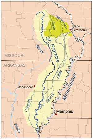 Map of the St. Francis River watershed showing Little River. The darker shade represents the Castor/Whitewater headwaters. | |
| Basin | |
| Main source |
Scott County, Missouri 230 ft (70 m) |
| River mouth | St. Francis River |
| Physical characteristics | |
| Length | 148 mi (238 km) |
The Little River is a tributary of the St. Francis River, about 148 miles (238 km) long,[1] in southeastern Missouri and northeastern Arkansas in the United States.[2] Via the St. Francis, it is part of the watershed of the Mississippi River.
The Little River's upper course in Missouri has been greatly altered by channelization practices. It originally collected the waters of the Castor and Whitewater rivers, but these streams' outlets have been diverted to the Mississippi River by the Headwater Diversion Channel and other drainage systems, and the Little River's course through the Missouri bootheel has been diverted to a canal, though traces of its original course still exist. In Arkansas the river passes through the Big Lake National Wildlife Refuge and joins the St. Francis River at Marked Tree.
Little River most likely derives its name via French La Petitie Riviere on account of its small size relative to other nearby rivers.[3]
See also
External links
References
- ↑ U.S. Geological Survey. National Hydrography Dataset high-resolution flowline data. The National Map, accessed March 9, 2011
- ↑ U.S. Geological Survey Geographic Names Information System: Little River (St. Francis River)
- ↑ "New Madrid County Place Names, 1928–1945". The State Historical Society of Missouri. Archived from the original on June 24, 2016. Retrieved November 19, 2016.
- Columbia Gazetteer of North America entry
- DeLorme (2004). Arkansas Atlas & Gazetteer. Yarmouth, Maine: DeLorme. ISBN 0-89933-345-1.
- DeLorme (2002). Missouri Atlas & Gazetteer. Yarmouth, Maine: DeLorme. ISBN 0-89933-353-2.
- U.S. Geological Survey Geographic Names Information System: Little River
Coordinates: 37°02′45″N 89°45′24″W / 37.0458832°N 89.7567527°W