Little Ararat
| Little Ararat | |
|---|---|
 A view of Little Ararat from Doğubeyazıt in Turkey | |
| Highest point | |
| Elevation | 3,925 m (12,877 ft) |
| Prominence | approx. 1,200 m (4,000 ft) |
| Coordinates | 39°39′N 44°24′E / 39.650°N 44.400°ECoordinates: 39°39′N 44°24′E / 39.650°N 44.400°E |
| Geography | |
 Little Ararat | |
| Parent range | Armenian Highlands |
| Geology | |
| Mountain type | Stratovolcano |
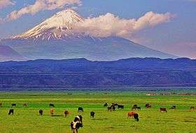
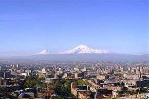
Little Ararat, also known as Mount Sis or Lesser Ararat (Turkish: Küçük Ağrı, Armenian: Փոքր Արարատ Pok’r Ararat or Սիս Sis), is the sixth tallest peak in Turkey. Until 1932, Little Ararat was on the Iranian side of the border. In 1932, Turkey and Iran had a border exchange agreement where Iran left this mountain in return for a town in Van.[1] It is a large satellite cone located on the eastern flank of the massive Mount Ararat, less than five miles west of Turkey's border with Iran. Despite being dwarfed by its higher and far more famous neighbor, Little Ararat is a significant volcano of its own with an almost perfectly symmetrical, conical form and smooth constructional slopes. It rises about 1,200 m (4,000 ft) above the saddle connecting it with the main peak.
See also
Notes
- ↑ "IBS No. 28 - Iran (IR) & Turkey (TU) 1964" (PDF), law.fsu.edu.
References
- "Little Ararat, Turkey". Peakbagger.com.