Lithuania District
| Lithuania District Verwaltungsbezirk Litauen | ||||||
| Military occupation authority of the German Empire | ||||||
| ||||||
| ||||||
 | ||||||
| Capital | Vilnius 54°41′N 25°17′E / 54.683°N 25.283°ECoordinates: 54°41′N 25°17′E / 54.683°N 25.283°E | |||||
| History | ||||||
| • | Established | 1915 | ||||
| • | Disestablished | 1918 | ||||

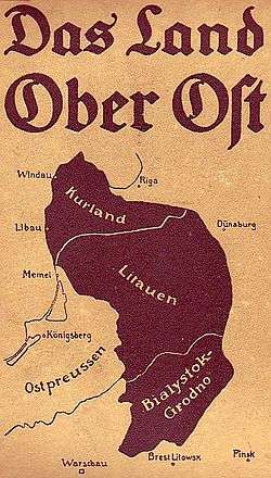
Lithuania District (German: Verwaltungsbezirk Litauen) was an administrative division of German-controlled territory of Ober-Ost during World War I. It was bordered by the Bialystok-Grodno District to the south and the Courland District to the north.[1][2]
History
The area was formed roughly from parts of the former Vilna Governorate and Suvalki Governorate of the Russian Empire.
References
- ↑ War Land on the Eastern Front: Culture, National Identity, and German Occupation in World War I, Review author[s]: Peter Gatrell
- ↑ Das Land Ober Ost (German)
This article is issued from Wikipedia - version of the 6/15/2016. The text is available under the Creative Commons Attribution/Share Alike but additional terms may apply for the media files.