Listed buildings in Widnes

Widnes is an industrial town in the Borough of Halton, Cheshire, England, on the north bank of the River Mersey where it narrows at Runcorn Gap. The town contains 21 buildings that are recorded in the National Heritage List for England as designated listed buildings. Of these, 5 are classified at Grade II*, and 16 at Grade II; Widnes has no Grade I listed buildings. In the United Kingdom, the term "listed building" refers to a building or other structure officially designated as being of special architectural, historical, or cultural significance. Listed buildings are categorised in three grades: Grade I consists of buildings of outstanding architectural or historical interest; Grade II* includes particularly significant buildings of more than local interest; Grade II consists of buildings of special architectural or historical interest. Buildings in England are listed by the Secretary of State for Culture, Media and Sport on recommendations provided by English Heritage, which also determines the grading.[1]
Before 1847, the area now occupied by the town of Widnes consisted of the hamlets of Farnworth, Cronton, Appleton, and Upton; a few scattered houses; and areas of mostly marshy farmland.[2] In 1833 a canal and a railway reached the area; the Sankey Canal was extended to a point on the River Mersey to the east of Runcorn Gap and the St Helens and Runcorn Gap Railway established a terminus adjacent to the canal. Widnes Dock, the world's first railway dock, was established at the new terminal,[3] and in 1847 John Hutchinson established the first chemical factory nearby.[2] During the second half of the 19th century, more chemical factories were built and the town grew, absorbing the previously separated hamlets.[4] The town became overcrowded[5] and highly polluted with smoke, chemical fumes, and waste.[6]
The town's listed buildings reflect its history. The oldest, St Luke's Church in the former village of Farnworth, dates from the 12th century. Also built before 1847 are three houses, a bridewell adjacent to St Luke's Church, and the lock at the terminus of the Sankey Canal. The buildings from after 1847—three churches and the cemetery chapels, one public building (the town hall), two railway stations, two bridges crossing the River Mersey, and the former power house of the now-demolished transporter bridge—largely reflect the growing population of the town and its increasing transport links. The Tower Building, formerly an office and now a museum, and a sewer vent, relate to the chemical industry. The latest structure to be listed is a war memorial in Victoria Park. Other than the bridges and the lock, the building materials used are brick or local red sandstone.
Key
| Grade | Criteria[7] |
|---|---|
| II* | Particularly important buildings of more than special interest |
| II | Buildings of national importance and special interest |
| Name and location | Photograph | Grade | Date | Description |
|---|---|---|---|---|
| St Luke's Church, Farnworth 53°23′04″N 2°43′38″W / 53.3844°N 2.7273°W |
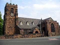 |
II* | 12th century with later additions | St Luke's is a parish church constructed in red sandstone dating from the late 12th century. Its tower was added in the 14th century. There were later additions and restorations, the final restoration being in 1894–95. The plan consists of a west tower, a five-bay nave with north and south aisles, a chancel, and north and south porches. At the east end of the north aisle is the Bold Chapel, which contains many family monuments, and the transept is known as the Cuerdley Chapel.[8][9][10] |
| Runcorn Railway Bridge 53°20′48″N 2°44′18″W / 53.3468°N 2.7383°W |
 |
II* | 1864–68 | Spanning the River Mersey to provide a more direct rail connection between London and Liverpool, the bridge is constructed of three wrought iron girders carried on four sandstone piers. It is approached on each side by viaducts. The structure was designed by William Baker and now carries the Liverpool branch of the West Coast Main Line.[11][12][13][14] |
| St Michael's Church, Ditton 53°21′45″N 2°45′40″W / 53.3625°N 2.7610°W |
 |
II* | 1876–79 | St Michael's is a Catholic church built for a Jesuit community who had been expelled from Germany in 1872. It is constructed in red sandstone ashlar and has a cruciform plan. At the west end is a tall tower with a saddleback roof.[15][16][17] |
| St Mary's Church, West Bank 53°20′56″N 2°43′58″W / 53.3488°N 2.7329°W |
 |
II* | 1908–10 | St Mary's parish church was built to replace an earlier church nearby which had been damaged by subsidence, It is constructed in red sandstone in Perpendicular style. It has a nave, aisles, transepts, chancel and a tower at the west end.[18][19][20] |
| Former power house of the Widnes-Runcorn transporter bridge 53°20′52″N 2°44′09″W / 53.34774°N 2.73595°W |
 |
II* | 1901 | This is a small red sandstone rectangular building in three storeys which originally contained the power house to drive the transporter bridge. It has been converted into use as an electrical sub-station.[21][22] |
| Norland's House 53°23′39″N 2°44′35″W / 53.39415°N 2.74312°W |
 |
II | Early 18th century | Norland's House is a farmhouse dating from the early 18th century with later alterations and additions. The house is built in brick on a stone plinth. It has two storeys and has been painted white. At the corners are rusticated quoins which have been painted black.[23] |
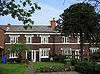
| The Hollies 53°22′52″N 2°43′43″W / 53.38107°N 2.72874°W |
 |
II | Late 18th century | The Hollies is a brick house with two storeys which was built in the 18th century. At the sides of its doorway are a Doric fluted columns and over it are moulded frieze and a fanlight. From 1867 to 1873 it was the home of Ludwig Mond.[24] |
| 103, 105, 107 and 109 Highfield Road 53°22′26″N 2°44′03″W / 53.3739°N 2.7341°W |
 |
II | Early 19th century | This is a terrace of four brick houses with slate roofs which were built in the early 19th century. They have two storeys with a string course between them.[25] |
| Farnworth bridewell 53°23′04″N 2°43′37″W / 53.38436°N 2.72699°W |
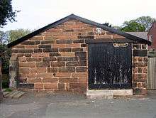 |
II | 1827 | This was originally a bridewell situated adjacent to St Luke's churchyard. It is a plain rectangular building in red sandstone with a slate roof.[26] |
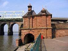
| Mersey Lock, Sankey Canal 53°21′09″N 2°43′54″W / 53.3525°N 2.7317°W |
 |
II | 1833 | The lock is at Spike Island, the terminus of the Sankey Canal where it joins the River Mersey. There is a difference of 12 feet (4 m) between the water level in the canal and the river.[27] |
| St Bede's Church 53°22′16″N 2°43′51″W / 53.3711°N 2.7308°W |
 |
II | 1847 | St Bede's is a Catholic church built in red sandstone. The west tower is broad and has angle buttresses and gargoyles. The plan of the church consists of a nave with aisles, and a chancel with a tripartite east end.[28][29] |
| Tower Building, now part of Catalyst Science Discovery Centre 53°21′07″N 2°44′01″W / 53.35184°N 2.73364°W |
|
II | c. 1860 | Tower Building was constructed for the chemical firm of Hutchinson & Co and was later used by Gossage's. In 1989 it was converted into a museum; a glass-surrounded observation deck was built on the roof and a glass external lift was added to the east.[30][31][32] |
| St Marie's Church 53°21′45″N 2°43′38″W / 53.3624°N 2.7271°W |
 |
II | 1864 | This was a Catholic church which was designed by E. W. Pugin and has been little altered since. It is built in red brick with sandstone dressings. Its plan consists of a nave and apse with lean-to aisles. The church became redundant in 2006 and was listed the same year.[33][34] |
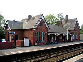
| Hough Green railway station 53°22′21″N 2°46′30″W / 53.37245°N 2.77507°W |
 |
II | 1872 | The station was built in brick for the Cheshire Lines Committee. It has an H-shaped plan with gables at each end and a canopy between.[35][36] |
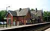
| Widnes railway station 53°22′43″N 2°44′01″W / 53.37856°N 2.73361°W |
 |
II | 1872 | Widnes station was built in brick for the Cheshire Lines Committee. It has an H-shaped plan with gables at each end and a canopy between. It was originally called Farnworth station.[37][38][39] |
| Former town hall 53°21′43″N 2°43′55″W / 53.36195°N 2.73183°W |
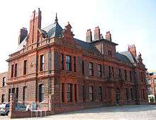 |
II | 1885 | The former Widnes Town Hall is built in brick with terra cotta dressings. It is a symmetrical building in nine bays with an ornate central bay and Dutch gables over the outer bays.[33][40] |
| Sewer vent 53°22′21″N 2°43′07″W / 53.372410°N 2.718569°W |
 |
II | c. 1893 | This chimney-like structure is a sewer ventilation shaft, built in decorated brickwork and approximately 30 feet (9 m) high. It is the last survivor of a system of seven vents whose purpose was to remove the effluent from chemical manufacture.[41][42] |
| Cemetery chapels 53°22′51″N 2°44′09″W / 53.3809°N 2.7358°W |
 |
II | 1897 | This is a pair of joined gabled chapels that are built in red sandstone. Between the chapels is a tower with an octagonal steeple. Part of the structure has been converted into a crematorium with the steeple used as a chimney.[43] |
| Wayside pulpit, St Mary's Church 53°20′54″N 2°43′59″W / 53.348433°N 2.732975°W |
 |
II | c. 1910 | This sandstone structure is a pulpit which forms part of the boundary wall of the churchyard of St Mary's Church. It incorporates a religious text which reads, "Go out into the highways and compel them to come in that my house may be filled".[44] |
| War memorial, Victoria Park 53°22′28″N 2°43′49″W / 53.37454°N 2.73039°W |
 |
II | 1921 | Listed in 2007, the memorial is built in York and Portland stone. It comprises an obelisk surmounted by a flaming urn which stands on a plinth on a platform. The sculptor was Herbert Tyson Smith.[45][46][47] |
| Kingsway Health Centre 53°21′48″N 2°43′59″W / 53.3633°N 2.7330°W |
 |
II | 1938–39 | This a rare example of a 1930s comprehensive health centre outside London. It is designed in Moderne style and incorporates Art Deco elements. It was listed in 2009, and the associated walls, gates and railings are included in the listing.[48] |
| Silver Jubilee Bridge 53°20′47″N 2°44′16″W / 53.3463°N 2.7379°W |
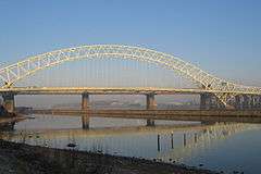 |
II | 1956–61 | This road bridge crosses the River Mersey and links Runcorn with Widnes, replacing the former Widnes–Runcorn Transporter Bridge. It is a through arch bridge which carries a four-lane carriageway and a cantilevered footway to the east. Its span is 1,082 feet (330 m) and its total length is 1,628 feet (496 m).[49][50][51] |
References
Citations
- ↑ Listed buildings, English Heritage, retrieved 24 April 2011
- 1 2 Hardie 1950, pp. 1–3
- ↑ Diggle 1961, pp. 17–19
- ↑ Morris 2005, p. 171
- ↑ Morris 2005, pp. 172–174
- ↑ Morris 2005, pp. 208–209
- ↑ Listed Buildings, Historic England, retrieved 3 April 2015
- ↑ Foster 1981, pp. 35–42
- ↑ Pollard & Pevsner 2006, pp. 653–655
- ↑ Historic England, "Church of St Luke, Widnes (1130417)", National Heritage List for England, retrieved 23 September 2013
- ↑ Historic England, "Runcorn Bridge railway bridge over River Mersey (1130418)", National Heritage List for England, retrieved 23 September 2013
- ↑ Starkey 1990, pp. 166–170
- ↑ Nickson 1887, pp. 202–206
- ↑ Cowan 1990, pp. 5–7, 10
- ↑ Diggle 1961, pp. 66–67
- ↑ Pollard & Pevsner 2006, p. 657
- ↑ Historic England, "Church of St Michael, Ditton (1325926)", National Heritage List for England, retrieved 23 September 2013
- ↑ Diggle 1961, pp. 120–121
- ↑ Pollard & Pevsner 2006, pp. 648–649
- ↑ Historic England, "Church of St Mary, Widnes (1130420)", National Heritage List for England, retrieved 23 September 2013
- ↑ Thompson 2000, pp. 12–15
- ↑ Historic England, "Former Transporter Bridge Power House, Widnes (1130419)", National Heritage List for England, retrieved 23 September 2013
- ↑ Historic England, "Norland's House, Widnes (1330352)", National Heritage List for England, retrieved 23 September 2013
- ↑ Historic England, "The Hollies, Widnes (1130413)", National Heritage List for England, retrieved 23 September 2013
- ↑ Historic England, "Nos. 103, 105, 107 & 109 Highfield Road, Widnes (1130414)", National Heritage List for England, retrieved 23 September 2013
- ↑ Historic England, "Bridewell adjacent to Church of St Luke, Widnes (1330353)", National Heritage List for England, retrieved 23 September 2013
- ↑ Historic England, "Mersey Lock St Helens Canal, Widnes (1330354)", National Heritage List for England, retrieved 23 September 2013
- ↑ Pollard & Pevsner 2006, pp. 652–653
- ↑ Historic England, "Church of St Bede, Widnes (1130411)", National Heritage List for England, retrieved 23 September 2013
- ↑ Hardie 1950, p. 56
- ↑ Pollard & Pevsner 2006, p. 650
- ↑ Historic England, "Gossage's Tower, Widnes (1130415)", National Heritage List for England, retrieved 23 September 2013
- 1 2 Pollard & Pevsner 2006, p. 651
- ↑ Historic England, "Roman Catholic Church of St Marie, Widnes (1391829)", National Heritage List for England, retrieved 23 September 2013
- ↑ Pollard & Pevsner 2006, pp. 656, 658
- ↑ Historic England, "Hough Green Railway Station (1330351)", National Heritage List for England, retrieved 23 September 2013
- ↑ Pollard & Pevsner 2006, p. 656
- ↑ Dyckhoff 1999, p. 74
- ↑ Historic England, "Widnes North Railway Station (1106340)", National Heritage List for England, retrieved 23 September 2013
- ↑ Historic England, "Widnes Town Hall (1330355)", National Heritage List for England, retrieved 23 September 2013
- ↑ Pollard & Pevsner 2006, p. 652
- ↑ Historic England, "Brick sewer vent, Widnes (1130416)", National Heritage List for England, retrieved 23 September 2013
- ↑ Historic England, "Pair of Cemetery Chapels, Widnes (1130412)", National Heritage List for England, retrieved 23 September 2013
- ↑ Historic England, "Wayside pulpit to Church of St Mary, Widnes (1325946)", National Heritage List for England, retrieved 23 September 2013
- ↑ Pollard & Pevsner 2006, p. 653
- ↑ Historic England, "War memorial, Victoria Park, Widnes (1392210)", National Heritage List for England, retrieved 23 September 2013
- ↑ Morris & Roberts 2012, pp. 250–251
- ↑ Historic England, "Kingsway Health Centre and associated walls, gates and railings, Widnes (1393291)", National Heritage List for England, retrieved 23 September 2013
- ↑ Historic England, "Runcorn-Widnes Road Bridge (1130421)", National Heritage List for England, retrieved 23 September 2013
- ↑ Hartwell et al. 2011, p. 562
- ↑ Starkey 1990, p. 222
Sources
- Cowan, C. A. (1990), Runcorn Railway Bridge, Crossing the Runcorn Gap, 3, Halton: Halton Borough Council
- Diggle, Rev. G. E. (1961), A History of Widnes, Corporation of Widnes, OCLC 450270
- Dyckhoff, Nigel (1999), Portrait of the Cheshire Lines Committee, Shepperton: Ian Allan, ISBN 978-0-711-02521-9
- Foster, Alan (1981), A History of Farnworth Church, its Parish and Village, Widnes, OCLC 48671380
- Hardie, D. W. F. (1950), A History of the Chemical Industry in Widnes, London: Imperial Chemical Industries Limited, OCLC 7503517
- Hartwell, Clare; Hyde, Matthew; Hubbard, Edward; Pevsner, Nikolaus (2011) [1971], Cheshire, The Buildings of England, New Haven and London: Yale University Press, ISBN 978-0-300-17043-6
- Morris, Edward; Roberts, Emma (2012), Public Sculpture of Cheshire and Merseyside (excluding Liverpool), Public Sculpture of Britain, 15, Liverpool: Liverpool University Press, ISBN 978-1-84631-492-6
- Morris, Jean M. (2005), Into the Crucible, Countryvise Limited, ISBN 1-901231-61-5
- Nickson, Charles (1887), History of Runcorn, London and Warrington: Mackie & Co., OCLC 5389146
- Pollard, Richard; Pevsner, Nikolaus (2006), Lancashire: Liverpool and the South-West, The Buildings of England, New Haven and London: Yale University Press, ISBN 0-300-10910-5
- Starkey, H. F. (1990), Old Runcorn, Halton Borough Council
- Thompson, Dave (2000), Bridging the Mersey: A Pictorial History, Zaltbommel: European Library, ISBN 978-9-028-82640-3
| Wikimedia Commons has media related to Widnes. |