Listed buildings in Halsall
Halsall is a civil parish in the West Lancashire district of Lancashire, England. It contains 17 buildings that are recorded in the National Heritage List for England as designated listed buildings. Of these, one is listed at Grade I, the highest of the three grades, and the others are at Grade II, the lowest grade. The parish contains the villages of Halsall and Shirdley Hill, and is otherwise rural. The Leeds and Liverpool Canal runs through the parish, and the listed buildings associated with it are four bridges and a milestone. The other listed buildings include a church and structures in the churchyard, houses, a ha-ha, a ruined building, a boundary stone, and a war memorial.
Key
| Grade | Criteria[1] |
|---|---|
| I | Buildings of exceptional interest, sometimes considered to be internationally important |
| II | Buildings of national importance and special interest |
Buildings
| Name and location | Photograph | Date | Notes | Grade |
|---|---|---|---|---|
| St Cuthbert's Church 53°35′08″N 2°57′09″W / 53.58545°N 2.95245°W |
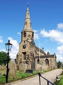 |
Early 14th century | The oldest part of the church is the chancel, the nave was rebuilt later in the century, and the tower was added in the 15th century. A grammar school was built on the south of the church in 1593. The spire was rebuilt in 1852, and the church was restored in 1873, and further restored in 1886, by Paley and Austin. The church is in sandstone, the chancel roof is in sheet metal, and the other roofs are in stone-slate. The church consists of a west steeple with an embattled projection to the south (the former grammar school), a nave, aisles, a south porch, a chancel, and a north vestry. The steeple has a tower, its lower part is square, it broaches to an octagon, and is surmounted by a spire with lucarnes. On the apex of the gable at the east end of the nave is an octagonal bellcote, and at the junction of the nave and chancel, on both sides, are rood turrets, each with a crocketed spirelet.[2][3] | I |
| Ruins of building 53°35′10″N 2°56′55″W / 53.58606°N 2.94870°W |
— |
14th century | The ruin is of a building of uncertain type. It is in sandstone, and its walls rise to a maximum of about 5 metres (16 ft). It contains doorways, piers, and parts of window surrounds.[4] | II |
| Sundial 53°35′07″N 2°57′08″W / 53.58528°N 2.95227°W |
 |
c. 1700 | The sundial is in the churchyard of St Cuthbert's Church. It is in sandstone and has a base on two square steps. The stem is cylindrical with a central swelling, and there is a moulded cornice. On the top is a brass plate and gnomon.[5][6] | II |
| Halsall Hall 53°35′01″N 2°57′23″W / 53.58372°N 2.95627°W |
— |
Early 18th century (probable) | The building, whose original use is uncertain, has been converted into cottages. It is in brick on a stone plinth with sandstone dressings. The building has two storeys with attics, and a front of ten bays. The central two bays are pedimented and contain a Venetian-style attic window. The windows in the upper floor are sashes, and those in the ground floor and at the rear are mullioned. The windows have Tudor arched heads.[7][8] | II |
| Harker's Bridge 53°34′16″N 2°57′23″W / 53.57111°N 2.95651°W |
 |
1774 | This is bridge No. 23, and it carries Plex Lane over the Leeds and Liverpool Canal. The bridge is in sandstone and consists of a single elliptical arch. It has a solid parapet with coping.[9] | II |
| Hill Bridge 53°34′36″N 2°57′06″W / 53.57668°N 2.95166°W |
 |
1774 | This is bridge No. 24, an accommodation bridge over the Leeds and Liverpool Canal. The bridge is in sandstone and consists of a single elliptical arch. It has a solid parapet with coping.[10] | II |
| Bridge No. 26 53°35′21″N 2°56′24″W / 53.58906°N 2.94006°W |
 |
1774 | Bridge No. 26 carries North Moor Lane over the Leeds and Liverpool Canal. The bridge is in sandstone and consists of a single elliptical arch. It has a solid parapet with coping.[11] | II |
| Weaver's Bridge 53°35′33″N 2°56′09″W / 53.59254°N 2.93587°W |
 |
1774 | This is bridge No. 27, and it carries Morris Lane over the Leeds and Liverpool Canal. The bridge is in sandstone and consists of a single elliptical arch. It has a solid parapet with coping.[12] | II |
| 58 New Street 53°34′56″N 2°57′23″W / 53.58221°N 2.95639°W |
— |
Early 19th century | The house is in brick with a slate roof, and has two storeys and three bays. The windows are sashes with stone sills and lintels. In the centre is a doorway with Tuscan pilasters, an open pediment, and a fanlight.[13] | II |
| 3A Summerwood Lane 53°35′07″N 2°57′05″W / 53.58529°N 2.95138°W |
— |
Early 19th century | A brick house with a slate roof, in two storeys and with a symmetrical front of three bays. The windows are sashes, with stone sills and lintels. The central doorway has a stone doorcase with pilasters, a fanlight, and an open pediment.[14] | II |
| Boundary stone 53°35′32″N 2°55′52″W / 53.59236°N 2.93118°W |
— |
Early 19th century | The boundary stone is in sandstone and has a wedge-shaped plan. Its faces are inscribed "Halsall" and "Scarisbrick".[15] | II |
| La Mancha 53°36′24″N 2°57′33″W / 53.60677°N 2.95910°W |
— |
Early to mid 19th century | A brick house on a sandstone plinth, with a cornice and a slate roof. There are two storeys, and a front of five unequal bays. The windows are casements with brick hood moulds. The doorway has engaged fluted columns, a segmental fanlight, and a cornice.[16] | II |
| Old font 53°35′07″N 2°57′09″W / 53.58528°N 2.95241°W |
 |
Early to mid 19th century | The font is in the churchyard of St Cuthbert's Church. It is in sandstone and has an octagonal plan with a narrow stem decorated with blind tracery. Each side of the bowl has two panels containing a carved shield.[17] | II |
| Halsall House 53°35′16″N 2°56′53″W / 53.58773°N 2.94796°W |
— |
1844–45 | The house, designed by Sydney Smirke, is in sandstone with a slate roof, and is in Jacobean style. It has two storeys with cellars and attics, and has an irregular plan. The entrance front is symmetrical, and has a five bay central section loggia and short gabled wings at the sides. The central doorway has a Perpendicular arch, and on the front some of the windows are mullioned and transomed, and others are cross windows. The south front has two gabled bays and French windows, and at the southeast corner is a turret that has an ogival cap with a weathervane. On the north side are service extensions and a 20th-century conservatory.[5][18] | II |
| Ha-ha, Halsall House 53°35′15″N 2°56′58″W / 53.58741°N 2.94932°W |
— |
c. 1850 | The ha-ha is in sandstone and runs parallel to the three main faces of the house, and about 50 metres (160 ft) away from it. It is about 1 metre (3 ft 3 in) deep, and two later bridges have been built across it.[19] | II |
| Milestone 53°34′23″N 2°57′18″W / 53.57297°N 2.95498°W |
— |
19th century | The milestone is by the towpath of the Leeds and Liverpool Canal. It is in cast iron and has a triangular plan. Its sides are inscribed with the distances in miles to Liverpool and Leeds.[20] | II |
| War memorial 53°35′06″N 2°57′12″W / 53.58508°N 2.95330°W |
 |
c.1920 | The war memorial incorporates a cross base probably from the 15th century. The cross base is in sandstone and the rest of the memorial is in limestone. The base has a square plan chamfered to an octagon, and it stands on four octagonal steps. The tapering shaft is also octagonal, and the head is gabled with a carving of the Crucifixion. On the second step is an inscription, including the names of those who were lost.[5][21] | II |
References
Citations
- ↑ Historic England
- ↑ Pollard & Pevsner (2006), pp. 192–194
- ↑ Historic England (1073159)
- ↑ Historic England (1278327)
- 1 2 3 Pollard & Pevsner (2006), p. 194
- ↑ Historic England (1361839)
- ↑ Pollard & Pevsner (2006), pp. 194–195
- ↑ Historic England (1278331)
- ↑ Historic England (1073160)
- ↑ Historic England (1361840)
- ↑ Historic England (1230999)
- ↑ Historic England (1073161)
- ↑ Historic England (1361841)
- ↑ Historic England (1073163)
- ↑ Historic England (1073162)
- ↑ Historic England (1231008)
- ↑ Historic England (1278324)
- ↑ Historic England (1073023)
- ↑ Historic England (1073024)
- ↑ Historic England (1230998)
- ↑ Historic England (1073158)
Sources
- Pollard, Richard; Pevsner, Nikolaus (2006), Lancashire: Liverpool and the South-West, The Buildings of England, New Haven and London: Yale University Press, ISBN 0-300-10910-5
- Historic England, "Church of St Cuthbert, Halsall (1073159)", National Heritage List for England, retrieved 6 November 2015
- Historic England, "Ruins of building approximately 230 metres north north-east of Church of St Cuthbert, Halsall (1278327)", National Heritage List for England, retrieved 6 November 2015
- Historic England, "Sundial approximately 10 metres south of Church of St Cuthbert, Halsall (1361839)", National Heritage List for England, retrieved 6 November 2015
- Historic England, "Halsall Hall (1278331)", National Heritage List for England, retrieved 6 November 2015
- Historic England, "Harker's Bridge (No 23), Halsall (1073160)", National Heritage List for England, retrieved 6 November 2015
- Historic England, "Hill Bridge (No 24), Halsall (1361840)", National Heritage List for England, retrieved 6 November 2015
- Historic England, "Bridge No 26, Halsall (1230999)", National Heritage List for England, retrieved 6 November 2015
- Historic England, "Weaver's Bridge (No 27), Halsall (1073161)", National Heritage List for England, retrieved 6 November 2015
- Historic England, "No. 58 New Street, Halsall (1361841)", National Heritage List for England, retrieved 6 November 2015
- Historic England, "No. 3A Summerwood Lane, Halsall (1073163)", National Heritage List for England, retrieved 6 November 2015
- Historic England, "Boundary Stone, Halsall (1073162)", National Heritage List for England, retrieved 6 November 2015
- Historic England, "La Mancha, Halsall (1231008)", National Heritage List for England, retrieved 6 November 2015
- Historic England, "Old font approximately 1 metre southeast of Church of St Cuthbert, Halsall (1278324)", National Heritage List for England, retrieved 6 November 2015
- Historic England, "Halsall House (1073023)", National Heritage List for England, retrieved 5 November 2015
- Historic England, "Ha-ha to east, south and west of Halsall House (1073024)", National Heritage List for England, retrieved 5 November 2015
- Historic England, "Milestone approximately 200 metres north of Harker's Bridge, Halsall (1230998)", National Heritage List for England, retrieved 6 November 2015
- Historic England, "War Memorial, Halsall (1073158)", National Heritage List for England, retrieved 5 November 2015
- Historic England, Listed Buildings, retrieved 5 November 2015
This article is issued from Wikipedia - version of the 3/26/2016. The text is available under the Creative Commons Attribution/Share Alike but additional terms may apply for the media files.