Listed buildings in Hale, Halton
Hale is a civil parish in the borough of Halton, Cheshire, England. The parish contains 17 buildings that are recorded in the National Heritage List for England as designated listed buildings. Of these, one is listed at Grade II*, the middle grade, and the others are at Grade II, the lowest grade. The parish includes the village of Hale, and this is surrounded by agricultural land. It is on the north bank of the River Mersey and includes the promontory of Hale Head. Almost all of the listed buildings are houses and cottages in the village, the others consisting of the parish church, an ice house in the grounds of the former Hale House (now demolished), and a former lighthouse on Hale Head.
Key
| Grade | Criteria[1] |
|---|---|
| II* | Particularly important buildings of more than special interest |
| II | Buildings of national importance and special interest |
Buildings
| Name and location | Photograph | Date | Notes | Grade |
|---|---|---|---|---|
| St Mary's Church 53°19′57″N 2°47′43″W / 53.3325°N 2.7952°W |
 |
14th century | The tower dates from the 14th century, the rest of the church was built in 1754, the interior was fully restored in 1979–80 after a fire.[2][3] | II |
| Manor House 53°20′02″N 2°47′45″W / 53.3339°N 2.7959°W |
 |
Mid 17th century | The house was originally built as a parsonage.[4] | II* |
| 22 High Street 53°20′09″N 2°48′08″W / 53.3357°N 2.8021°W |
 |
1665 | A timber-framed cottage with a thatched roof.[5] | II |
| 32–34 Town Lane 53°20′15″N 2°47′51″W / 53.3376°N 2.7976°W |
 |
Late 17th century | A pair of brick-built cottages.[6] | II |
| 4-6 Hale Road 53°20′12″N 2°48′18″W / 53.3367°N 2.8051°W |
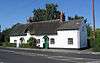 |
Late 17th ;century | A pair of thatched lime-washed brick cottages.[7] | II |
| 14 Church End 53°20′02″N 2°47′51″W / 53.3339°N 2.7974°W |
 |
Late 17th century | A cottage, formerly timber-framed, now lime-washed brick with a thatched roof.[8] | II |
| 16-20 Church End 53°20′01″N 2°47′48″W / 53.3337°N 2.7968°W |
 |
Late 17th century | A row of three cottages, formerly timber-framed, now lime-washed brick with thatched roofs.[9] | II |
| Old School House, 4 High Street 53°20′11″N 2°48′14″W / 53.3363°N 2.8039°W |
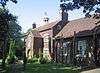 |
1739 | A two-storey brick building surmounted by a cupola.[10] | II |
| 39-43 High Street 53°20′08″N 2°48′03″W / 53.3356°N 2.8008°W |
 |
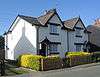
18th century | Three joined brick buildings with a slate roof.[11] | II |
| 45-51 High Street 53°20′07″N 2°48′01″W / 53.3354°N 2.8004°W |
 |
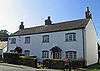
18th century | A pair of lime-washed brick cottages with slate roofs.[12] | II |
| 46 High Street 53°20′07″N 2°48′01″W / 53.3352°N 2.8004°W |
 |
18th century | A lime-washed brick single-storey cottage with a stone plinth.[13] | II |
| 42-44 High Street 53°20′07″N 2°48′02″W / 53.3353°N 2.8006°W |
 |
18th century | Two joined lime-washed brick two-storey cottages.[14] | II |
| 2-2A Church End 53°20′06″N 2°47′56″W / 53.3349°N 2.7989°W |
 |
Mid 18th century | A lime-washed brick two-storey house.[15] | II |
| 38-40 High Street 53°20′07″N 2°48′04″W / 53.3354°N 2.8010°W |
 |
Late 18th century | A pair of lime-washed two-storey cottages with slate roofs, each of one bay with a gable.[16] | II |
| 55-59 High Street 53°20′07″N 2°47′59″W / 53.3352°N 2.7996°W |
 |
Late 18th ;century | Three joined lime-washed cottages in one storey with attics.[17] | II |
| Ice house 53°19′55″N 2°48′19″W / 53.3319°N 2.8053°W |
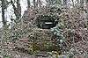 |
Mid 19th century | The ice house of the former Hale Hall (now demolished) in brick under an earth mound.[18] | II |
| Lighthouse 53°19′21″N 2°47′39″W / 53.3225°N 2.7941°W |
 |
Early 20th century | A disused lighthouse built in brick with a metal roof.[19] | II |
References
Citations
- ↑ Historic England
- ↑ Pollard & Pevsner (2006), p. 189
- ↑ Historic England (1130454)
- ↑ Historic England (1330339)
- ↑ Historic England (1115609)
- ↑ Historic England (1130458)
- ↑ Historic England (1330340)
- ↑ Historic England (1130452)
- ↑ Historic England (1130453)
- ↑ Historic England (1130456)
- ↑ Historic England (1130455)
- ↑ Historic England (1115649)
- ↑ Historic England (1330342)
- ↑ Historic England (1115617)
- ↑ Historic England (1330338)
- ↑ Historic England (1130457)
- ↑ Historic England (1330341)
- ↑ Historic England (1278048)
- ↑ Historic England (1320324)
Sources
- Historic England, "Church of St Mary, Hale (1130454)", National Heritage List for England, retrieved 12 February 2015
- Historic England, "The Manor House, Hale (1330339)", National Heritage List for England, retrieved 12 February 2015
- Historic England, "No. 22 High Street, Hale (1115609)", National Heritage List for England, retrieved 12 February 2015
- Historic England, "Nos. 32 and 34 Town Lane, Hale (1130458)", National Heritage List for England, retrieved 12 February 2015
- Historic England, "Nos. 4-6 Hale Road, Hale (1330340)", National Heritage List for England, retrieved 12 February 2015
- Historic England, "No. 14 Church End, Hale (1130452)", National Heritage List for England, retrieved 12 February 2015
- Historic England, "Nos. 16–20 Church End, Hale (1130453)", National Heritage List for England, retrieved 12 February 2015
- Historic England, "Old School House, Hale (1130456)", National Heritage List for England, retrieved 12 February 2015
- Historic England, "Smithy Garage, Hale (1130455)", National Heritage List for England, retrieved 12 February 2015
- Historic England, "Nos. 45, 47, 49, and 51 High Street, Hale (1115649)", National Heritage List for England, retrieved 12 February 2015
- Historic England, "No. 46 High Street, Hale (1330342)", National Heritage List for England, retrieved 12 February 2015
- Historic England, "Nos. 42 and 44 High Street, Hale (1115617)", National Heritage List for England, retrieved 12 February 2015
- Historic England, "Nos. 2 and 2A Church End, Hale (1330338)", National Heritage List for England, retrieved 12 February 2015
- Historic England, "Nos. 38 and 40 High Street, Hale (1130457)", National Heritage List for England, retrieved 12 February 2015
- Historic England, "Nos. 55, 57 and 59 High Street, Hale (1330341)", National Heritage List for England, retrieved 12 February 2015
- Historic England, "Ice House 400 metres west of the former Hale Hall, Hale (1278048)", National Heritage List for England, retrieved 12 February 2015
- Historic England, "Hale Head Lighthouse (1320324)", National Heritage List for England, retrieved 12 February 2015
- Historic England, Listed Buildings, retrieved 1 April 2015
- Pollard, Richard; Pevsner, Nikolaus (2006), Lancashire: Liverpool and the South-West, The Buildings of England, New Haven and London: Yale University Press, ISBN 0-300-10910-5
This article is issued from Wikipedia - version of the 10/20/2015. The text is available under the Creative Commons Attribution/Share Alike but additional terms may apply for the media files.