Listed buildings in Bickerstaffe
Bickerstaffe is a civil parish in the West Lancashire district of Lancashire, England. It contains twelve listed buildings that are recorded in the National Heritage List for England. All of the listed buildings are designated at Grade II, the lowest of the three grades, which is applied to "buildings of national importance and special interest".[1] The parish contains the village of Bickerstaffe and the hamlet of Barrow Nook, and is otherwise rural. The listed buildings include houses, farmhouses and farm buildings, a church, structures associated with the Friends' Burial Ground, a converted windmill, a boundary stone, stocks, and a war memorial.
Buildings
| Name and location | Photograph | Date | Notes |
|---|---|---|---|
| Tithe Barn Farmhouse 53°32′11″N 2°50′58″W / 53.53648°N 2.84941°W |
— |
1723 | A pebbledashed brick house with a stone-slate roof in two storeys and two bays. The central doorway has a gabled porch, and the windows have segmental heads. Above the door is a small tablet with a shield of arms, and to the right of it is an inscribed plaque.[2] |
| Bickerstaffe Stocks 53°32′28″N 2°50′30″W / 53.54098°N 2.84171°W |
— |
1750 or earlier | The stocks consist of two rectangular round-headed sandstone pillars. They are about 1 metre (3 ft 3 in) high with slots on the inner sides, and contain modern planks with two ankle holes.[3] |
| Bickerstaffe Hall 53°31′49″N 2°50′26″W / 53.53029°N 2.84042°W |
— |
1772 | A brick house on a stone plinth with some stone dressings and a slate roof. It has two storeys with an attic, and a front of three bays. The windows are sashes that have stone sills and rusticated lintels with keystones. The doorway has a moulded surround and a timber lean-to porch. Above the plinth is a re-set inscribed plaque dated 1667, and above the doorway is a plaque carved with an eagle and a child. On the roof is a cupola bellcote. The moated site on which the hall stands is a scheduled monument.[4][5][6] |
| Eastern barn and engine house, Bickerstaffe Hall Farm 53°31′48″N 2°50′22″W / 53.53011°N 2.83951°W |
— |
Late 18th century | The building was extended to the right in the 19th century with a taller addition. It is in brick, and has a roof partly of slate and partly of stone-slate. The openings include a cart entrance with a canopy, doorways, windows, and pitching holes. At the rear is a projecting wing with external steps.[7] |
| South-western barn, Bickerstaffe Hall Farm 53°31′47″N 2°50′23″W / 53.52974°N 2.83963°W |
— |
Late 18th century | The barn is in brick, and has a roof partly of slate and partly of stone-slate. The openings include cart entrances with segmental arches, windows, a pitching hole, ventilation slits, and three low arched entrances. Above one of the cart entrances is the coat of arms of the Earl of Derby.[8] |
| Old Windmill 53°32′12″N 2°50′38″W / 53.53667°N 2.84378°W |
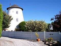 |
Late 18th century (probable) | The windmill has been converted for domestic use. It is in rendered brick with a conical roof, and has a circular plan. There are three storeys, and the windows date from the 20th century. There is a doorway on the north side, and later extensions to the east.[9][10] |
| Mounting block 53°32′05″N 2°52′30″W / 53.53469°N 2.87501°W |
— |
c. 1800 | The mounting block is in the Friends' Burial Ground. It is in sandstone, and consists of three steps, each from a separate block of stone.[11] |
| Gateway and farm buildings, Bickerstaffe Hall Farm 53°31′49″N 2°50′24″W / 53.53021°N 2.83993°W |
— |
Early 19th century | The farm buildings are in brick with a slate roof. The main part is symmetrical with two storeys and three bays and a central gable. There are horizontal sliding sash windows in the upper floor, and in the ground floor are three elliptical arches, the central one being larger and forming a gateway. The main part is flanked by single-storey ranges, and at the rear is an animal pen.[12] |
| Holy Trinity Church 53°31′55″N 2°50′17″W / 53.53200°N 2.83808°W |
 |
1843 | The church, designed by Sydney Smirke, was enlarged in 1860. It is in sandstone with slate roofs, and consists of a nave, a north aisle, a chancel with a polygonal apse, a north vestry, and a west steeple. The steeple has a tower with angle buttresses, corner pinnacles, and with flying buttresses to the spire. Inside the church is a west gallery.[13][14] |
| Boundary stone 53°32′50″N 2°52′44″W / 53.54712°N 2.87879°W |
— |
Mid 19th century | The boundary stone is in sandstone and is cylindrical. It is inscribed 'Aughton' and 'Bickerstaffe' on the top, and "Boundary stone" on the front.[15] |
| Wall, gate and gate piers 53°32′06″N 2°52′29″W / 53.53496°N 2.87478°W |
— |
1880 and earlier | The walls, which enclose three sides of the Friends' Burial Ground, and the gate piers are in sandstone. The gate piers have a square plan, cornices and pyramidal caps. The gates are in wrought iron.[16] |
| War memorial 53°31′55″N 2°50′18″W / 53.53190°N 2.83834°W |
 |
c. 1920 | The war memorial is in the churchyard of Holy Trinity Church. It is in limestone and in Gothic style. The memorial has a square base with square chamfered corner piers standing on three square steps. The body of the memorial has slim diagonal buttresses with crocketed pinnacles, and on the top is a crocketed shaft and an inscribed cross fleury.[13][17] |
References
Citations
- ↑ Historic England
- ↑ Historic England (1278411)
- ↑ Historic England (1392018)
- ↑ Pollard & Pevsner (2006), pp. 147–148
- ↑ Historic England (1230796)
- ↑ Historic England (1011999)
- ↑ Historic England (1073140)
- ↑ Historic England (1230815)
- ↑ Pollard & Pevsner (2006), p. 148
- ↑ Historic England (1361829)
- ↑ Historic England (1073141)
- ↑ Historic England (1361830)
- 1 2 Pollard & Pevsner (2006), p. 147
- ↑ Historic England (1230794)
- ↑ Historic England (1073133)
- ↑ Historic England (1230818)
- ↑ Historic England (1073139)
Sources
- Pollard, Richard; Pevsner, Nikolaus (2006), Lancashire: Liverpool and the South-West, The Buildings of England, New Haven and London: Yale University Press, ISBN 0-300-10910-5
- Historic England, "Tithe Barn Farmhose, Bickerstaffe (1278411)", National Heritage List for England, retrieved 30 October 2015
- Historic England, "Bickerstaffe Stocks (1392018)", National Heritage List for England, retrieved 30 October 2015
- Historic England, "Bickerstaffe Hall (1230796)", National Heritage List for England, retrieved 30 October 2015
- Historic England, "Moated site at Bickerstaffe Hall (1011999)", National Heritage List for England, retrieved 30 October 2015
- Historic England, "North-eastern barn and attached engine house at Bickerstaffe Hall Farm, Bickerstaffe (1073140)", National Heritage List for England, retrieved 30 October 2015
- Historic England, "South-western barn at Bickerstaffe Hall Farm, Bickerstaffe (1230815)", National Heritage List for England, retrieved 30 October 2015
- Historic England, "The Old Windmill, Bickerstaffe (1361829)", National Heritage List for England, retrieved 30 October 2015
- Historic England, "Mounting block in Friends' Burial Ground, Bickerstaffe (1073141)", National Heritage List for England, retrieved 30 October 2015
- Historic England, "Gateway and attached farm buildings on north-west side of farmyard at Bickerstaffe Hall Farm, Bickerstaffe (1361830)", National Heritage List for England, retrieved 30 October 2015
- Historic England, "Church of Holy Trinity, Bickerstaffe (1230794)", National Heritage List for England, retrieved 30 October 2015
- Historic England, "Boundary stone at SD 418 059, Bickerstaffe (1073133)", National Heritage List for England, retrieved 30 October 2015
- Historic England, "Walls enclosing 3 sides of Friends' Burial Ground, with pair of gatepiers and gates, Bickerstaffe (1230818)", National Heritage List for England, retrieved 30 October 2015
- Historic England, "War Memorial, Bickerstaffe (1073139)", National Heritage List for England, retrieved 30 October 2015
- Historic England, Listed Buildings, retrieved 28 October 2015
This article is issued from Wikipedia - version of the 11/29/2015. The text is available under the Creative Commons Attribution/Share Alike but additional terms may apply for the media files.