Listed buildings in Bewcastle
Bewcastle is a civil parish in the Carlisle district of Cumbria, England. It contains 19 listed buildings that are recorded in the National Heritage List for England. Of these, one is listed at Grade II*, the middle of the three grades, and the others are at Grade II, the lowest grade. The parish is almost entirely rural or forested. It extends to the Scottish border, and four of the listed buildings originated as bastle houses (fortified farmhouses). Most of the other listed buildings are houses, farmhouses and farm buildings, the others including a church, a former public house, and a monument.
Key
| Grade | Criteria[1] |
|---|---|
| II* | Particularly important buildings of more than special interest |
| II | Buildings of national importance and special interest |
Buildings
| Name and location | Photograph | Date | Notes | Grade |
|---|---|---|---|---|
| St Cuthbert's Church 55°03′49″N 2°40′55″W / 55.06360°N 2.68197°W |
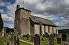 |
13th century | The tower dates from 1792, and the south side of the church was altered in 1901. It is built in calciferous sandstone, with quoins, the tower is partly rendered, and the roof is of green slate. The church consists of a single cell, with a short tower incorporating a porch at the west end. The tower has two storeys, a doorway and windows with round arches that have impost blocks and keystones. At the top is an open bellcote and a hipped roof with a weathervane. The windows in the body of the church are lancets, and inside the church is a west gallery.[2][3] | II* |
| Crew Castle 55°05′36″N 2°40′40″W / 55.09340°N 2.67768°W |
— |
16th century (probable) | Originally a bastle house, now in ruins and used as a sheep pen. It is in calciferous sandstone on projecting plinth stones, and has large quoins. The walls are over 1.5 metres (4 ft 11 in) thick and rise only to the ground floor level. The south entrance has large jamb stones, and the north entrance is blocked. It is also a scheduled monument.[4][5][6] | II |
| Peel 0' Hill 55°04′13″N 2°41′32″W / 55.07022°N 2.69221°W |
— |
Late 16th century (probable) | Originally a bastle house and later a farmhouse, it was expanded in 1811. The house is in rubble on projecting plinth stones, and it has a Welsh slate roof. There are two storeys and three bays, a lower two-storey two-bay extension to the right, and a single-storey outbuilding to the left. The original part has very thick walls. The windows in the ground floor are casements and a fire window, and in the upper floor they are sashes.[7] | II |
| Ruins of The Loan 55°05′57″N 2°41′22″W / 55.09903°N 2.68935°W |
— |
Late 16th century (probable) | The ruins of a bastle house, in calciferous sandstone on a projecting plinth, and with large quoins. The entrance has chamfered and rebated jambs and a lintel, and there is a slit vent. It is also a scheduled monument.[8][9] | II |
| Wall, Low Grains 55°04′07″N 2°39′54″W / 55.06852°N 2.66494°W |
— |
Late 16th to early 17th century (probable) | The wall incorporates the remains of a bastle house and a 17th-century farmhouse. It is in calciferous sandstone with very thick walls, and has foundations measuring about 5 metres (16 ft) by 9 metres (30 ft). The entrance has rounded jambs and a lintel. The adjoining wall contains the blocked windows of the former farmhouse. It is also a scheduled monument.[4][10][11] | II |
| Sleetbeck 55°04′39″N 2°47′13″W / 55.07755°N 2.78688°W |
— |
Late 17th century | The house was altered in 1744. It is in calciferous sandstone on a squared plinth, with quoins and it has a green slate roof with coped gables. There are two storeys with attics, and seven bays. The doorway has a moulded architrave with a dentilled moulded pediment, above which is a carved coat of arms. The windows are sashes, and the attic windows have chamfered surrounds and have retained their chamfered mullions.[12] | II |
| Demesne Farmhouse 55°03′52″N 2°40′58″W / 55.06440°N 2.68267°W |
 |
Late 17th to early 18th century | The farmhouse was altered in the 19th century. It is in sandstone, some taken from Bewcastle Castle, and it has a Welsh slate roof. There are two storeys and two bays, with a two-bay extension. The doorway has a quoined surround, and the sash windows have plain surrounds. There are also blocked mullioned windows and fire windows.[13] | II |
| Former Horse and Farrier Inn 55°04′39″N 2°45′49″W / 55.07746°N 2.76348°W |
— |
Late 17th to early 18th century | Originally a public house, later a private house, it is in sandstone with a corrugated iron roof. It has a single storey and three bays, and a 19th-century single-bay extension to the right. The doorway has a plain surround, and at the rear are sash windows. Inside there are two original full crucks.[14] | II |
| Low Grains 55°04′08″N 2°39′55″W / 55.06879°N 2.66528°W |
— |
Late 17th to early 18th century | Originally a farmhouse and barn, altered in 1754, and later used as farm buildings. They are in calciferous sandstone with roofs in Welsh slate and corrugated iron. The former house has one storey and four bays, and the barn, at right angles, has two storeys. The former house has a doorway with a quoined surround, and windows with the mullions removed and chamfered surrounds. In the barn are a cart entrance and ventilation slits.[15] | II |
| Whintingstown 55°04′31″N 2°45′03″W / 55.07517°N 2.75082°W |
— |
1701 | A sandstone farmhouse on a projecting plinth with a roof of corrugated iron. It is in a single storey and has four bays. The doorway has a quoined surround with a dated and inscribed lintel, and there is a similar, blocked entrance to the left. The windows are a mix of sashes and casements. Inside there are five upper crucks in the roof space.[16] | II |
| The Ash 55°04′49″N 2°46′06″W / 55.08030°N 2.76835°W |
— |
1738 | A farmhouse that incorporates earlier features, it is in calciferous sandstone on a chamfered plinth, with quoins, a string course, a cornice, and a Welsh slate roof with coped gables. There is a rear extension in brick and stone. There are two storeys and five bays, and an extension giving a T-shaped plan. The doorway has a moulded architrave, a segmental moulded pediment, and a fanlight. The windows are sashes in moulded architraves.[17] | II |
| Town Foot 55°05′52″N 2°41′30″W / 55.09785°N 2.69178°W |
— |
1763 | A farmhouse and barn in rubble with a Welsh slate roof. They are in a single storey, the house having three bays, and the barn to the right. The entrance has a chamfered stone surround and a dated lintel, the windows are sashes, and there is a fire window at the rear. In the barn is an entrance, and ventilation slits at two levels.[18] | II |
| Outbuildings, Sleetbeck 55°04′40″N 2°47′13″W / 55.07770°N 2.78702°W |
— |
Late 18th century (probable) | The outbuildings are in calciferous sandstone with a Welsh slate roof. They are in one storey with a loft, and have an L-shaped plan. The openings include doorways, windows, and a loft door.[19] | II |
| The Flatt and outbuildings 55°06′04″N 2°41′28″W / 55.10106°N 2.69109°W |
— |
1781 | The farmhouse was extended in the 19th century. It is in ashlar on a chamfered plinth, with quoins, a shaped cornice, and a green slate roof with coped gables. There are two storeys, the original part has three bays, the extension to the right has two bays, and there is a lean-to single-bay extension to the left. The doorway has a moulded architrave with a pulvinated frieze and a triangular moulded pediment, and the windows are sashes. At the rear is a tall round-headed stair window. The outbuildings at the rear form an L-shaped plan, they are in rubble, and have roofs of green and Welsh slate. They have two storeys, and the openings include a projecting cart entrance, garage doors, plank doors, and ventilation slits.[20] | II |
| Lordstown 55°06′50″N 2°45′52″W / 55.11380°N 2.76436°W |
— |
Early 19th century | A farmhouse in calciferous sandstone with quoins, eaves modillions, and a Welsh slate roof. It has two storeys and three bays, with a single-storey single-bay extension to the right. The door has a fanlight with a quoined surround, and the windows are sashes in plain raise surrounds.[21] | II |
| Round house, Roanstrees 55°05′46″N 2°45′22″W / 55.09621°N 2.75608°W |
 |
Early 19th century | A small circular building with a steep conical roof, whose original purpose was unknown; it was possibly a flax drying shed. It is built in rubble with a roof of sandstone slabs. There is a plank door in a quoined surround, and casement windows were added later.[4][22] | II |
| Barn, Roanstrees 55°05′46″N 2°45′21″W / 55.09615°N 2.75594°W |
— |
1832 | The barn is in sandstone with a Welsh slate roof. It is in a single storey, and has a large cart entrance with a segmental arch and a dated keystone, and ventilation slits in two levels.[23] | II |
| Banna 55°03′48″N 2°40′55″W / 55.06328°N 2.68194°W |
— |
1837 | Originally a rectory, it is in sandstone on a squared plinth, with quoins and a slate roof. There are two storeys and three bays flanked by two-storey single-bay wings. The doorway has a quoined surround and an entablature with a keystone, and the windows are sashes, some with hood moulds.[24] | II |
| Davidson's Monument 55°09′04″N 2°43′56″W / 55.15122°N 2.73212°W |
 |
1852 | The monument commemorates Thomas Davidson, a game watcher who was killed by poachers in 1848. It is in calciferous sandstone, and consists of a rusticated plinth, a square shaft with an inscription, and a pyramidal cap.[25] | II |
References
Citations
- ↑ Historic England
- ↑ Hyde & Pevsner (2010), p. 155
- ↑ Historic England (1087539)
- 1 2 3 Hyde & Pevsner (2010), p. 156
- ↑ Historic England (1087533)
- ↑ Historic England (1015738)
- ↑ Historic England (1280894)
- ↑ Historic England (1087534)
- ↑ Historic England (1016085)
- ↑ Historic England (1087535)
- ↑ Historic England (1015866)
- ↑ Historic England (1205178)
- ↑ Historic England (1205133)
- ↑ Historic England (1205166)
- ↑ Historic England (1205091)
- ↑ Historic England (1087541)
- ↑ Historic England (1335618)
- ↑ Historic England (1087538)
- ↑ Historic England (1335619)
- ↑ Historic England (1205077)
- ↑ Historic England (1087536)
- ↑ Historic England (1087537)
- ↑ Historic England (1205120)
- ↑ Historic England (1205144)
- ↑ Historic England (1087540)
Sources
- Historic England, "Church of St Cuthbert, Bewcastle (1087539)", National Heritage List for England, retrieved 4 April 2016
- Historic England, "Crew Castle, Bewcastle (1087533)", National Heritage List for England, retrieved 4 April 2016
- Historic England, "Crew Castle bastle, Bewcastle (1015738)", National Heritage List for England, retrieved 4 April 2016
- Historic England, "Peel 0' Hill, Bewcastle (1280894)", National Heritage List for England, retrieved 4 April 2016
- Historic England, "Ruins of 'The Loan', Bewcastle (1087534)", National Heritage List for England, retrieved 4 April 2016
- Historic England, "The Loan medieval bastle and post-medieval cottage, Bewcastle (1016085)", National Heritage List for England, retrieved 4 April 2016
- Historic England, "Wall to south-east of Low Grains, Bewcastle (1087535)", National Heritage List for England, retrieved 4 April 2016
- Historic England, "Low Grains bastle, Bewcastle (1015866)", National Heritage List for England, retrieved 4 April 2016
- Historic England, "Sleetbeck, Bewcastle (1205178)", National Heritage List for England, retrieved 4 April 2016
- Historic England, "Demesne Farmhouse, Bewcastle (1205133)", National Heritage List for England, retrieved 4 April 2016
- Historic England, "Former Horse and Farrier Inn, Bewcastle (1205166)", National Heritage List for England, retrieved 4 April 2016
- Historic England, "Low Grains, Bewcastle (1205091)", National Heritage List for England, retrieved 4 April 2016
- Historic England, "Whintingstown, Bewcastle (1087541)", National Heritage List for England, retrieved 4 April 2016
- Historic England, "The Ash, Bewcastle (1335618)", National Heritage List for England, retrieved 4 April 2016
- Historic England, "Town Foot, Bewcastle (1087538)", National Heritage List for England, retrieved 4 April 2016
- Historic England, "Outbuildings north of Sleetbeck, Bewcastle (1335619)", National Heritage List for England, retrieved 4 April 2016
- Historic England, "The Flatt and adjoining outbuildings, Bewcastle (1205077)", National Heritage List for England, retrieved 4 April 2016
- Historic England, "Lordstown, Bewcastle (1087536)", National Heritage List for England, retrieved 4 April 2016
- Historic England, "Round House in centre of farmyard at Roanstrees, Bewcastle (1087537)", National Heritage List for England, retrieved 4 April 2016
- Historic England, "Barn to west of Roanstrees, Bewcastle (1205120)", National Heritage List for England, retrieved 4 April 2016
- Historic England, "Banna, Bewcastle (1205144)", National Heritage List for England, retrieved 4 April 2016
- Historic England, "Davidson's Monument, Bewcastle (1087540)", National Heritage List for England, retrieved 4 April 2016
- Hyde, Matthew; Pevsner, Nikolaus (2010) [1967], Cumbria, The Buildings of England, New Haven and London: Yale University Press, ISBN 978-0-300-12663-1
- Historic England, Listed Buildings, retrieved 4 April 2016
This article is issued from Wikipedia - version of the 4/4/2016. The text is available under the Creative Commons Attribution/Share Alike but additional terms may apply for the media files.