List of the highest points of the German states

(1493)
(2962.06)
(32.5)
(120.1)
(201)
(116.2)
(950.0)
(179.2)
(971.2)
(843.2)
(816.32)
(695.4)
(1214.8)
(1141.2)
(167.4)
(982.9)
This list of the highest points of the German states shows the highest mountain or hill in each German federal state together with its height and links to lists of other mountains and hills.
Overview
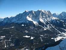
At 2,962.06 m above sea level (NHN), the highest mountain in Germany is Bavaria's Zugspitze, whose height until 2000 was given as 2,961.47 m above sea level (NN).[1] The lowest height occurs in the city of Bremen: at 32.5 m the highest natural point of the smallest German state is located in Friedehorst Park in the Bremen quarter of Burglesum, although the rubbish tip in Bremen-Blockland, whose summit reaches 49 m, is higher. The highest natural point in the capital city of Berlin, the Große Müggelberg, is, at 114.7 m[2] still 5.4 metres lower than the rubble heap of the Teufelsberg, which was piled up after the Second World War and reaches a height of 120.1 m;[3] but the highest point in Berlin is an artificially created mound of the Arkenberge, which attains a height of about 122 m.[4] Together with the highest points of the states of Hamburg, Schleswig-Holstein and Mecklenburg-Vorpommern, none reaches a height of 200 m.
At 201 m, the Kutschenberg is the highest summit in Brandenburgs. However, the highest point in the state is actually a spot on the Heidehöhe which reaches 201.4 m, but whose summit lies a few metres over the border in the neighbouring state of Saxony.[5]
The only summit of the sixteen that is not marked by a summit cross or a stone is the rise in Friedehorst Park. The summit of the Großer Beerberg lies within a biosphere reserve and is not, therefore, accessible to the public. However, peak baggers may count the observation platform which lies just below the summit.[5]
List
This list of the highest mountains or hills in each of the German states is sorted by height in metres (m) above sea level (NHN):


See also
References
- 1 2 "Kundeninformation 3/2009" (pdf; 1,1 MB) (in German). Landesamt für Vermessung und Geoinformation Bayern. 2009-09. p. 2. Retrieved 2012-12-13. Check date values in:
|date=(help) - ↑ Neuvermessung: Jetzt ist der Teufelsberg der Größte. In: Der Tagesspiegel, 27. April 2013
- ↑ Teufelsberg auf den Seiten des Bezirks Charlottenburg-Wilmersdorf, abgerufen am 23. Mai 2013
- 1 2 Arkenberge schlägt Teufelsberg, vom 28. Januar 2015, abgerufen am 12. Februar 2015, auf pankower-allgemeine-zeitung.de
- 1 2 "Bezwinger der 16 Riesen". tagesschau.de. Archived from the original on 2011-12-14. Retrieved 2011-12-26.
- 1 2 3 4 Map services of the Federal Agency for Nature Conservation
- ↑ Foto der auf dem Kutschenberg stehenden Stele mit Inschrift, auf commons.wikimedia.org
- ↑ Der Friedhorstpark (32,5 m) – Höchster Punkt Bremens, in books.google.de
- ↑ Höhe der Erhebung laut Geologischem Landesamt Hamburg und bis 2013 laut Aufschrift des Gipfelkreuzes
- ↑ Geodata Viewer by the Mecklenburg-Western Pomerania Office of Geoinformation, Survey and Land Registration (Amt für Geoinformation, Vermessungs- und Katasterwesen Mecklenburg-Vorpommern)
- ↑ Topographische Karte, TK25, Nr. 4229, Braunlage, M = 1:25.000
- ↑ Topographic Information Management, Cologne - NRW GEObasis Division (info)
- ↑ Artikel Wie hoch ist der Erbeskopf nun wirklich? und gleichnamige Pressemitteilung (PDF; 145 kB) des Landesamtes für Vermessung und Geobasisinformation Rheinland-Pfalz vom 17. Januar 2008 auf lvermgeo.rlp.de (abgerufen am 31. Januar und 1. Februar 2013).
- ↑ Höhe des Dollbergs laut Dollberge (Karte und Info) auf Saarlandbilder.net und laut Aufschrift des Gipfelschildes
- ↑ Staatsbetrieb Geobasisinformation und Vermessung Sachsen (GeoSN). Die nivellitische Bestimmung dieser DHHN92-Höhe wurde am 12. August 2004 von Vertretern des damaligen Landesvermessungsamtes Sachsen (jetzt Staatsbetrieb Geobasisinformation und Vermessung Sachsen) durchgeführt (die Höhe bezieht sich auf die höchste Stelle des Fichtelberges außerhalb baulicher Anlagen). abgerufen am 21. Dezember 2010, auf landesvermessung.sachsen.de
- ↑ Saxony-Anhalt viewer of the State Office for Survey and Geoinformation (Landesamt für Vermessung und Geoinformation)
Mountains and hills by state of Germany | ||
|---|---|---|