List of protected heritage sites in Herve
This table shows an overview of the protected heritage sites in the Walloon town Herve. This list is part of Belgium's national heritage.
| Object |
Year/architect |
Town/section |
Address |
Coordinates |
Number? |
Image |
|---|---|---|---|---|---|---|
| Nazareth Farm: main facade (nl) (fr) |
Herve | avenue Reine Astrid n°15, Herve | 50°38′42″N 5°47′59″E / 50.644986°N 5.799848°E |
63035-CLT-0001-01 Info |
||
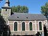
| Church of St. John the Baptist (nl) (fr) |
Herve | 50°38′23″N 5°47′42″E / 50.639594°N 5.794900°E |
63035-CLT-0002-01 Info |
 | ||
| Old fountain behind the building (nl) (fr) |
Herve | rue Jardon n°11, Herve | 50°38′14″N 5°47′36″E / 50.637358°N 5.793454°E |
63035-CLT-0004-01 Info |
||
| Former convent of Récollectines: walls and roofs, and building of monastery chapel and monastery interior (nl) (fr) |
Herve | rue Haute, Herve | 50°38′34″N 5°47′46″E / 50.642816°N 5.796081°E |
63035-CLT-0005-01 Info |
||
| Church of Saint-Apollinaire (nl) (fr) |
Herve | 50°39′43″N 5°45′45″E / 50.661880°N 5.762429°E |
63035-CLT-0008-01 Info |
 | ||
| Chapel of Our Lady of Noble Haye (nl) (fr) |
Herve | 50°39′04″N 5°45′48″E / 50.651019°N 5.763270°E |
63035-CLT-0010-01 Info |
|||
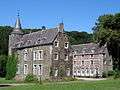
| The castle-farm of Bolland and the church and park (nl) (fr) |
Herve | 50°39′43″N 5°45′42″E / 50.661937°N 5.761736°E |
63035-CLT-0011-01 Info |
 | ||
| The castle-farm of Bolland and the church and park (nl) (fr) |
Herve | Bolland | 50°39′49″N 5°45′18″E / 50.663727°N 5.755069°E |
63035-CLT-0012-01 Info |
.jpg) | |
| Noblehaie farmhouse (nl) (fr) |
Herve | Noblehaie n°104, Bolland | 50°39′03″N 5°45′52″E / 50.650800°N 5.764317°E |
63035-CLT-0013-01 Info |
||
| Chaineux village (nl) (fr) |
Herve | Village n°260-261, Chaineux | 50°38′02″N 5°49′37″E / 50.633804°N 5.826949°E |
63035-CLT-0015-01 Info |
||
| house (nl) (fr) |
Herve | Grand Vinâve 30, Charneux | 50°40′07″N 5°48′17″E / 50.668708°N 5.804613°E |
63035-CLT-0016-01 Info |
||
| Church Saint-Sébastien (nl) (fr) |
Herve | Charneux | 50°40′10″N 5°48′18″E / 50.669461°N 5.805118°E |
63035-CLT-0018-01 Info |
||
| Farmhouse (nl) (fr) |
Herve | rue de la Sauvenière n°116 | 50°40′17″N 5°47′25″E / 50.671366°N 5.790367°E |
63035-CLT-0020-01 Info |
||
| Farmhouse (nl) (fr) |
Herve | rue de la Halle n°18, Grand-Rechain | 50°36′23″N 5°48′36″E / 50.606265°N 5.809936°E |
63035-CLT-0021-01 Info |
||
| "Père Eternel" house <sup style="text-align:right; line-height:1em;
margin-left:0.3em; color:blue; cursor:help; font-family:Verdana,sans-serif;"
title="Gebouw genaamd "Père Eternel": gevels, daken en bordes">(nl) (fr) |
Herve | rue Jardon n°88, Herve | 50°38′15″N 5°47′24″E / 50.637600°N 5.790131°E |
63035-CLT-0022-01 Info |
||
| Old house (nl) (fr) |
Herve | Renouprez n°283, Herve | 50°40′14″N 5°49′39″E / 50.670535°N 5.827431°E |
63035-CLT-0023-01 Info |
||
| The chapel of Sainte-Agathe (nl) (fr) |
Herve | 50°38′02″N 5°49′48″E / 50.633767°N 5.830028°E |
63035-CLT-0024-01 Info |
.JPG) | ||
| Old house (nl) (fr) |
Herve | rue Leclercq n°66 | 50°38′32″N 5°47′50″E / 50.642218°N 5.797347°E |
63035-CLT-0025-01 Info |
||
| Old house (nl) (fr) |
Herve | Halleux n°341 | 50°40′25″N 5°49′11″E / 50.673622°N 5.819827°E |
63035-CLT-0026-01 Info |
||
| Gerardy farmhouse (nl) (fr) |
Herve | n°58, Houlteau | 50°37′49″N 5°50′36″E / 50.630264°N 5.843228°E |
63035-CLT-0027-01 Info |
||
| Old house (nl) (fr) |
Herve | rue d'Elvaux n°7, Herve | 50°38′20″N 5°47′40″E / 50.638959°N 5.794425°E |
63035-CLT-0028-01 Info |
||
| Havremont farmhouse (nl) (fr) |
Herve | Sarémont 12 (formerly called Havremont rue Grétry 140), Bolland | 50°39′23″N 5°46′33″E / 50.656447°N 5.775922°E |
63035-CLT-0029-01 Info |
||
| Old house (nl) (fr) |
Herve | avenue des Platanes n°156, Grand-Rechain | 50°36′28″N 5°48′39″E / 50.607804°N 5.810886°E |
63035-CLT-0030-01 Info |
||
| Old house (nl) (fr) |
Herve | Es Bosse n°255, Chaîneux | 50°38′16″N 5°49′54″E / 50.637759°N 5.831650°E |
63035-CLT-0031-01 Info |
||
| house (nl) (fr) |
Herve | Grand Vinâve 11, Charneux | 50°40′09″N 5°48′21″E / 50.669210°N 5.805716°E |
63035-CLT-0032-01 Info |
||
| Farmhouse (nl) (fr) |
Herve | Holiguette 220, Charneux | 50°41′42″N 5°47′49″E / 50.695095°N 5.796939°E |
63035-CLT-0033-01 Info |
||
| "Le Prieuré" house <sup style="text-align:right; line-height:1em;
margin-left:0.3em; color:blue; cursor:help; font-family:Verdana,sans-serif;"
title="Gevels en daken van het gedeelte gebouw in de 17e eeuw van het gebouw genaamd "Le Prieuré", en de totaliteit van het interieur, met name de schoorstenen, stucwerk-plafonds, het vertrek en de eerste vlucht van de trap, met op de etage alle houtwerk van het interieur: nis, deuren en luiken van de genoemde trap">(nl) (fr) |
Herve | rue du Village n°276, Chaineux | 50°38′02″N 5°50′05″E / 50.633763°N 5.834607°E |
63035-CLT-0034-01 Info |
||
| Farmhouse (nl) (fr) |
Herve | Xhéneumont n°7-8, Battice | 50°38′14″N 5°48′56″E / 50.637221°N 5.815562°E |
63035-CLT-0035-01 Info |
||
| Old house (nl) (fr) |
Herve | rue du Marché n°16, Herve | 50°38′28″N 5°47′44″E / 50.641131°N 5.795654°E |
63035-CLT-0036-01 Info |
||
| Organ of A. Clerinx in Saint-Gilles (nl) (fr) |
Herve | Chaineux | 50°37′54″N 5°50′05″E / 50.631731°N 5.834644°E |
63035-CLT-0038-01 Info |
||
| The facades and roofs of the two parts of the 18th century, Maria Theresia College (nl) (fr) |
Herve | rue du Collège 26, Herve | 50°38′21″N 5°47′44″E / 50.639137°N 5.795451°E |
63035-CLT-0039-01 Info |
||
| ancient abbey of Val-Dieu and the surrounding area (nl) (fr) |
Herve | 50°41′57″N 5°48′20″E / 50.699048°N 5.805559°E |
63035-CLT-0041-01 Info |
.jpg) | ||
| Forest Moraithier (nl) (fr) |
Herve | 50°35′35″N 5°47′24″E / 50.593048°N 5.790042°E |
63035-CLT-0042-01 Info |
|||
| Border marker called "Belle Pierre" <sup style="text-align:right; line-height:1em;
margin-left:0.3em; color:blue; cursor:help; font-family:Verdana,sans-serif;"
title="Oude grenspaal genaamd "Belle Pierre", op het aquaduct boven de stroom met de naam "ruisseau du Pont Clory"">(nl) (fr) |
Herve | 50°37′02″N 5°45′52″E / 50.617218°N 5.764576°E |
63035-CLT-0043-01 Info |
 |
See also
| Wikimedia Commons has media related to Cultural heritage monuments in Herve. |
References
- Belgian heritage register: Direction générale opérationnelle - Aménagement du territoire, Logement, Patrimoine et Energie (DG4)
- www.dglive.be