List of peninsulas

_250m.jpg)
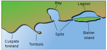
Presented below is a list of peninsulas. A peninsula (Latin: paeninsula from paene "almost" and insula "island") is a piece of land that is bordered by water on three sides but connected to mainland.[1][2][3][4] The surrounding water is usually understood to be continuous, though not necessarily named as such. A peninsula can also be a headland, cape, island promontory, bill, point, or spit.[5] A point is generally considered a tapering piece of land projecting into a body of water that is less prominent than a cape.[6] In English, the plural of peninsula is peninsulas or, less commonly, peninsulae. A river which courses through a very tight meander is also sometimes said to form a "peninsula" within the (almost closed) loop of water.
Africa

Horn of Africa
The Horn of Africa is a peninsula compassing of the countries of Somalia, Eritrea, Djibouti, and Ethiopia.
North Africa
- Cabo Blanco, Mauritania/Morocco
- Cap Bon, Tunisia
- Cap Zebib, Tunisia
- Ceuta, Spain
- Punta Durnford, Western Sahara
- Ponta de São Lourenço, Madeira Islands (Portuguese Territory)
- Ras Banas, Tunisia
- Ras ben Sakka, Tunisia
- Sinai, Egypt
Other
- Bakassi, Cameroon but disputed with Nigeria
- Cap-Vert, Senegal
- Turner's Peninsula, Sierra Leone
- Cape Peninsula, South Africa
- Le Morne Brabant, Mauritius
Antarctica
- Antarctic Peninsula
- Edward VII Peninsula
- Fletcher Peninsula
- Fowler Peninsula
- Martin Peninsula
Asia
China
Taiwan
Hong Kong
Russia
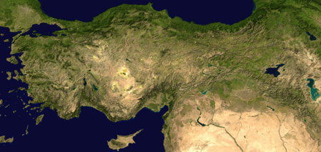
Turkey
Eastern Mediterranean
Indian subcontinent and South Asia
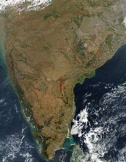
The Indian subcontinent is a peninsula, the only land feature in the world that is widely recognized as a subcontinent in the English language.
- Colaba peninsula, Mumbai
- Deccan peninsula
- Worli peninsula, Mumbai
- Kathiawar Peninsula, Gujarat
- Gwadar peninsula, Pakistan
- Manhoro, Karachi, Sindh, Pakistan
- Jaffna Peninsula, Northern Sri Lanka
- Kanyakumari peninsula, Tamil Nadu
Japan
Kyūshū
- Nishi-sonogi-hanto
- Kunisaki-hanto
- Satsuma-hanto
- Osumi-hanto
Honshū
Hokkaido
Kazakhstan
Korea

The whole land mass encompassing North and South Korea is a peninsula, surrounded by the Sea of Korea on the east, the East China Sea to the south, and the West Sea to the west, the Korea Strait connecting the first two bodies of water.
Persian Gulf
- Arabian Peninsula; Saudi Arabia, Iraq, Kuwait, Bahrain, Qatar, Jordan, United Arab Emirates, Yemen, Oman
- Qatar
- Al-Faw Peninsula, Iraq
- Musandam Peninsula; Oman, United Arab Emirates
Indochina
Indonesia
- Semenanjung Blambangan, Java,
- Semenanjung Minahassa, Sulawesi
- East Peninsula, Sulawesi
- South-east Peninsula, Sulawesi
- South Peninsula, Sulawesi
Malaysia
- Malay Peninsula
- Northwestern Peninsula, Kudat
- Pitas Peninsula, Pitas
- Semporna Peninsula, Semporna and Tawau
- Sandakan Peninsula, Sandakan
Philippines
Singapore
Vietnam
- Cà Mau Peninsula, Cà Mau Province
- Hòn Gốm Peninsula, Da Lat City
- Sơn Trà Peninsula, Da Nang
- Ngũ Xã Peninsula, Hanoi
- Bình Quới Peninsula, Ho Chi Minh City
- Cam Ranh Peninsula, Khánh Hòa Province
- Đầm Môn Peninsula
- Trà Cổ Peninsula, Quảng Ninh Province
- Phương Mai Peninsula, Qui Nhơn
Europe
Europe is sometimes considered to be a large peninsula extending off Eurasia.[7] As such, it is one of the largest peninsulas in the world and the only one to have the status as a full continent, largely as a matter of convention rather than science. It is composed of many smaller peninsulas, the four main component peninsulas being the Iberian, Scandinavian, Italian, and Balkan peninsulas.
Balkan Peninsula
The Balkans is a peninsula including Albania, Bosnia and Herzegovina, Bulgaria, Croatia, Greece, Kosovo, Macedonia, Montenegro, Romania, Serbia, Slovenia and the European part of Turkey.
- Chalkidiki, Greece
- Kassandra, Greece
- Mani Peninsula, Greece
- Mount Athos, Greece
- Peloponnese, Greece (now an island, since the Corinth Canal was made)
- Sithonia, Greece
- Pilio, Greece
- Istria, Croatia
- Piran Peninsula, Slovenia
- Pelješac, Croatia
- Prevlaka, Croatia
- Split, Croatia
- Zadar, Croatia
- Karaburun Peninsula, Albania
- Luštica, Montenegro
- Gallipoli, Turkey
Denmark
- Djursland
- Grenen
- Helgenæs
- Hindsholm
- Horne Land
- Hornsherred
- Jutland Peninsula (now an island, since the Kiel Canal was made)
- Kegnæs
- Mols
- Odsherred
- Salling
- Stevns Peninsula
- Sundeved
France
- Brittany
- Cap Corse, Corsica
- Cotentin Peninsula, Normandy
- Crozon, Finistère
- Landes du Médoc, Aquitaine
Iberian Peninsula

Encompassing continental Spain and Portugal, Andorra, British overseas territory of Gibraltar and a small amount of southern France.
- Lisbon Peninsula, Portugal
- Setúbal Peninsula, Portugal
- Peniche, Portugal
- Cabo Espichel, Portugal
- Cabo Carvoeiro, Portugal
- Cabo de São Vicente, Portugal
- Tróia Peninsula, Portugal
- Gibraltar
- Cádiz, Spain
- A Coruña, Spain
- O Morrazo, Spain
- Anaga, Spain
- Jandía, Spain
- La Isleta, Spain
Ireland
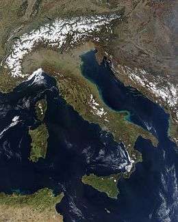
Italy
Malta
Russia

- Crimean peninsula, disputed between Ukraine and Russia
- Curonian Spit, Kaliningrad Oblast (shared with Lithuania)
- Gusinaya Zemlya
- Kanin Peninsula
- Kola Peninsula
- Kurgalsky Peninsula
- Lokhaniemi Peninsula
- Nemetsky Peninsula
- Onega Peninsula
- Rybachy Peninsula
- Sambia Peninsula
- Soikinsky Peninsula
- Sredny Peninsula
- Turiy Peninsula
- Yugorsky Peninsula
Scandinavia
Scandinavia is a peninsula and along with other islands encompassing present-day Sweden, Norway, Denmark, and part of Finland.
Denmark
- Djursland
- Grenen
- Helgenæs
- Hindsholm
- Horne Land
- Hornsherred
- Jutland Peninsula (now an island, since the Kiel Canal was made)
- Kegnæs
- Mols
- Odsherred
- Salling
- Stevns Peninsula
- Sundeved
Norway
- Bergen Peninsula
- Bygdøy
- Fornebulandet
- Fosen
- Hamarøyhalvøya
- Hurumlandet
- Lista
- Lyngenhalvøya
- Nordkinn Peninsula
- Nesodden
- Ofothalvøya
- Porsangerhalvøya
- Snarøya, Norway
- Stad
- Stavanger Peninsula
- Sværholt Peninsula
- Varangerhalvøya
Sweden
Turkey
Ukraine
- Crimean peninsula, disputed between Ukraine and Russia
- Chonhar Peninsula
- Kinburn peninsula
- Rybalskyi Peninsula
United Kingdom
England

- South West Peninsula (western part of the West Country comprising the counties of Cornwall, Devon, Somerset, and Dorset)
- Dengie peninsula, Essex
- The centre of the city of Durham, County Durham
- The Fylde, Lancashire
- Hoo, Kent
- Isle of Dogs, London
- Greenwich Peninsula, London
- Gosport, Hampshire
- Isle of Thanet, Kent
- The Lizard, Cornwall
- Manhood Peninsula, West Sussex
- Morte Point, North Devon
- Penwith, Cornwall
- Isle of Purbeck, Dorset
- Isle of Portland, Dorset
- Rotherhithe, London
- Spurn, East Riding of Yorkshire
- Shotley peninsula, Suffolk
- Tendring, Essex
- Wirral, Cheshire/Merseyside
Scotland
- Ardnamurchan, Lochaber
- Black Isle, Ross and Cromarty
- Cowal, Argyll and Bute
- Doonie Point, Aberdeenshire
- Dunnet Head, Caithness
- Faraid Head, Sutherland
- Fife
- Kintyre, Argyll and Bute
- Knoydart, Lochaber
- The Machars, Dumfries and Galloway
- Morvern, Lochaber
- Rhins of Galloway, Dumfries and Galloway
- Strathy Point, Sutherland
- Point of Hellia, Orkney
- Point or the Eye peninsula, Western Isles
Wales
- Creuddyn Peninsula juts out of the North Wales coast
- Gower Peninsula, Swansea
- Llŷn Peninsula
- Marloes Peninsula, Pembrokeshire
- Pembrokeshire peninsula, West Wales
- South Pembrokeshire Peninsula
- St Davids Head, Pembrokeshire
- South West Wales - Swansea to New Quay
- Wales, itself a peninsula
Northern Ireland
Channel Islands
Other peninsulas in Europe


- Absheron peninsula, Azerbaijan
- Akranes, Iceland
- Au peninsula, Au, Zurich, Switzerland
- Butjadingen, Germany
- Brøggerhalvøya, Norway
- Curonian Spit, Lithuania (shared with Russia)
- Fischland-Darß-Zingst, Germany
- Hel Peninsula, Poland
- Heracles Peninsula, disputed between Ukraine and Russia
- Kakumäe Peninsula, Estonia
- Kerch Peninsula, disputed between Ukraine and Russia
- Karpass Peninsula, Cyprus
- North Holland, the Netherlands
- Sõrve Peninsula, Estonia
- Tihany, Hungary
- Walcheren, the Netherlands
- Zuid-Beveland, the Netherlands
North America
Belize
Canada
- Acadian Peninsula, New Brunswick
- Adelaide Peninsula, Nunavut
- Aspotogan Peninsula, Nova Scotia
- Avalon Peninsula, Newfoundland, Newfoundland and Labrador
- Banks Peninsula, Nunavut
- Barrow Peninsula, Baffin Island, Nunavut
- Becher Peninsula, Baffin Island, Nunavut
- Beekman Peninsula, Baffin Island, Nunavut
- Bell Peninsula, Baffin Island, Nunavut
- Bell Peninsula, Southampton Island, Nunavut
- Blunt Peninsula, Baffin Island, Nunavut
- Bonavista Peninsula, Newfoundland, Newfoundland and Labrador
- Boothia Peninsula, Nunavut
- Borden Peninsula, Baffin Island, Nunavut
- Brodeur Peninsula, Baffin Island, Nunavut
- Bruce Peninsula, Ontario, extending into Lake Huron
- Burin Peninsula, Newfoundland, Newfoundland and Labrador
- Burrard Peninsula, British Columbia
- Chebucto Peninsula, Nova Scotia
- Colin Archer Peninsula, Devon Island, Queen Elizabeth Islands, Nunavut
- Collinson Peninsula, Victoria Island, Nunavut
- Cumberland Peninsula, Baffin Island, Nunavut
- Diamond Jennes Peninsula, Victoria Island, Northwest Territories
- Cynthia Peninsula, Ontario (in Lake Temagami)
- Douglas Peninsula, Northwest Territories
- Dunlas Peninsula, Melville Island, Northwest Territories/Nunavut
- Foxe Peninsula, Baffin Island, Nunavut
- Gaspé Peninsula, Quebec
- Great Northern Peninsula, Newfoundland, Newfoundland and Labrador
- Hall Peninsula, Baffin Island, Nunavut
- Henry Kater Peninsula, Baffin Island, Nunavut
- Joan Peninsula, Ontario (in Lake Temagami)
- Kent Peninsula, Nunavut
- Kingston Peninsula, New Brunswick
- Labrador Peninsula, encompassing all of Labrador and most of Quebec
- Leith Peninsula, Northwest Territories (in Great Bear Lake)
- Long Point, Ontario (in Lake Erie)
- McLean Peninsula, Ontario (in Lake Temagami)
- Melville Peninsula, Nunavut
- Meta Incognita Peninsula, Baffin Island, Nunavut
- Natkusiak Peninsula, Victoria Island, Northwest Territories/Nunavut
- Niagara Peninsula, Ontario
- North Peninsula, Ontario (in Lake Nipigon)
- Nova Scotia peninsula, Nova Scotia
- Pangertot Peninsula, Nunavut
- Parry Peninsula, Northwest Territories
- Pethel Peninsula, Northwest Territories
- Point Pelee, Ontario (in Lake Erie)
- Port au Port Peninsula, Newfoundland, Newfoundland and Labrador
- Prince Albert Peninsula, Victoria Island, Northwest Territories
- Prince Edward Peninsula, Ontario (in Lake Ontario)
- Sahoyúé-§ehdacho, Northwest Territories
- Sibley Peninsula, Ontario (in Lake Superior)
- Simpson Peninsula, Nunavut
- Siorarsuk Peninsula, Baffin Island, Nunavut
- Steensby Peninsula, Baffin Island, Nunavut
- Storkerson Peninsula, Victoria Island, Northwest Territories/Nunavut
- Saanich Peninsula, Vancouver Island, British Columbia
- Sunshine Coast Peninsula, Sea-to-Sky Corridor, British Columbia
- Ungava Peninsula, Quebec
- Wollaston Peninsula, Victoria Island, Northwest Territories/Nunavut
Caribbean
- Peninsula de Samaná, Dominican Republic
- Barrio Obrero, Puerto Rico
- Zapata Peninsula, Cuba
- Guanahacabibes Peninsula, Cuba
- Hicacos Peninsula, Cuba
Costa Rica
Greenland
- Alfred Wegeners Halvo
- Hayes Halvo
- Ingnerit
- Nuussuaq Peninsula
- Sigguup Nunaa (Svartenhuk Halvø)
Mexico
- Baja California Peninsula, Mexico, containing the states of Baja California and Baja California Sur
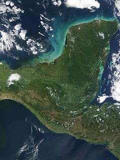
- Yucatán Peninsula, partly separating the Gulf of Mexico from the Caribbean
Panama
United States
Alaska
- Alaska Peninsula
- Cleveland Peninsula
- Kenai Peninsula
- Seward Peninsula
California
- Bay Farm Island, Alameda and Oakland International Airport
- Coronado Peninsula, a northwest-pointing peninsula, San Diego Bay to the East and Pacific Ocean to the West
- Marin County, California, a southwards-pointing peninsula surrounded by the Pacific Ocean, the northern part of San Francisco Bay, and San Pablo Bay
- Monterey Peninsula
- Palos Verdes Peninsula, South Bay, Los Angeles
- Point Dume, Malibu
- Point Loma, San Diego
- San Francisco Peninsula
- Samoa Peninsula, the larger, northern arm of land separating Humboldt Bay from the Pacific
- Balboa Peninsula in Newport Beach
Florida

Florida is a well-known example of a large peninsula, with its land area divided between the larger Florida peninsula and the smaller Florida panhandle on the north and west. It has several smaller peninsulas within it:
- The St. Johns River creates a large peninsula over 75 miles in length that stretches from eastern Jacksonville down to the border of Flagler and Volusia counties, where the river emanates from Lake George.
- Fairpoint Peninsula
- Pinellas peninsula including St. Petersburg and Clearwater
- Much of Tampa lies on a peninsula called Interbay Peninsula jutting out into Tampa Bay
- Cape Sable
Maryland

- Maryland shares the Delmarva Peninsula east of Chesapeake Bay with Delaware and Virginia.
- St. Mary's Peninsula is defined by the Patuxent River, the Potomac River, and Chesapeake Bay.
- Calvert Peninsula lies between Chesapeake Bay and the Patuxent River.
- Numerous smaller tidal tributaries form smaller peninsulas on both the Eastern and Western shores of Chesapeake Bay. Named examples include the Broadneck Peninsula in Anne Arundel County and the Elk Neck Peninsula in Cecil County.
Massachusetts

- Cape Cod, Massachusetts, a cape that can be viewed as a peninsula
- Nahant, a town in Essex County, is on a small peninsula.
- Nantasket Peninsula, Hull
Michigan
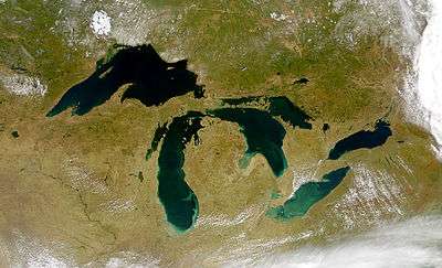
Michigan - the only bi-peninsular state - is very distinguishable for its mitten-shaped Lower Peninsula of Michigan which includes:
- Leelanau Peninsula
- Lost Peninsula
- Old Mission Peninsula
- Pointe Mouillee
- Presque Isle Peninsula
- Tawas Point
- The Thumb
- Waugoshance Point
- Woodtick Peninsula
The rifle-shaped Upper Peninsula of Michigan contains:
- Abbaye Peninsula
- Garden Peninsula
- Keweenaw Peninsula
- Rabbit's Back
- Stonington Peninsula
New Jersey
- Barnegat Peninsula
- Cape May Peninsula
- Sandy Hook
- New Barbadoes Neck lies between the Hackensack River and Passaic River
- Caven Point in Jersey City is a part of Liberty State Park and Port Liberte.
- Bergen Point and Constable Hook are two peninsulas in Bayonne, which itself lies on peninsula surrounded by Upper New York Bay, Newark Bay, and the Kill van Kull, formerly known as Bergen Neck
- Droyer's Point and Kearny Point mark the mouth of the Hackensack River
- MOTBY and Port Jersey are man-made peninisulas extending in Upper New York Bay
New York

- The Bronx, New York, and Yonkers, New York
- Long Island was once a peninsula connected to North America during the great Ice Ages, and includes two large peninsulas at its east end: the South Fork and the North Fork.
- Cumberland Head
- Coney Island was once an actual island until the island was expanded through land reclamation into the Coney Island Creek, thus becoming a peninsula.
- Rockaway Peninsula in southeastern Queens
- Irondequoit, NY (Geographical headland)
Utah
- Antelope Island, Utah, becomes a peninsula when waters are low, on the south shore of the Great Salt Lake
- Promontory Peninsula, on the north eastern shore of the Great Salt Lake
- Stansbury Peninsula becomes an island when waters are high, on the south shore of the Great Salt Lake
Virginia
- Middle Peninsula, on the western shore of the Chesapeake Bay
- Northern Neck, on the western shore of the Chesapeake Bay
- Virginia Peninsula, on the western shore of the Chesapeake Bay
Washington
- Key Peninsula in Puget Sound
- Kitsap Peninsula in Puget Sound
- Long Beach Peninsula
- Olympic Peninsula
- Magnolia, Seattle
Other states
- Delmarva Peninsula, encompassing parts of Maryland and Virginia, and most of Delaware
- Door Peninsula, Wisconsin, in Lake Michigan
- Mokapu, Hawaii
- Presque Isle, Erie, Pennsylvania
- Port Bolivar, Texas, On the Texas Coast.
- Encinal Peninsula, Flour Bluff, Corpus Christi, Texas.
- Kentucky Bend, Kentucky
South America
- Araya Peninsula, Venezuela
- Paraguana, Venezuela
- Paria Peninsula, Venezuela
- Guajira Peninsula, Venezuela/Colombia
- Illescas Peninsula, Peru
- Paracas Peninsula, Peru
- Verde Peninsula, Argentina
- Valdes Peninsula, Argentina
- Punta del Este, Uruguay
- Taitao Peninsula, Chile
- Brunswick Peninsula, Chile
- Itapagipe Peninsula, Brazil
- Cabo de São Tomé, Brazil
Oceania
Australia
- Beecroft Peninsula, New South Wales
- Bellarine Peninsula, Victoria
- Cape York Peninsula, Queensland
- Cobourg Peninsula, Northern Territory
- Kurnell Peninsula, New South Wales
- Dampier Peninsula, Western Australia
- Dudley Peninsula, South Australia
- Eyre Peninsula, South Australia
- Fleurieu Peninsula, South Australia
- Freycinet Peninsula, Tasmania
- Inskip Peninsula, Queensland
- Jervis Bay, Australian Capital Territory
- Mornington Peninsula, Victoria
- Redcliffe, Queensland
- Sir Richard Peninsula, South Australia
- Stockton, New South Wales
- Tasman Peninsula, Tasmania
- Wilsons Promontory, Victoria
- Woy Woy, New South Wales
- Yorke Peninsula, South Australia
- Younghusband Peninsula, South Australia
Papua New Guinea
New Zealand

- In the North Island
- In the South Island
See also
References
- ↑ Editors of the American Heritage Dictionaries, ed. (2004). Word Histories and Mysteries: From Abracadabra to Zeus. Houghton Mifflin Harcourt. p. 216. ISBN 978-0547350271. OCLC 55746553.
- ↑ "pen·in·su·la". American Heritage Dictionary of the English Language. Houghton Mifflin Harcourt. 2016. Retrieved 1 May 2016.
- ↑ "Definition of peninsula". Cambridge Dictionaries Online. Cambridge University Press. Retrieved 1 May 2016.
- ↑ "Definition of peninsula". Merriam-Webster Dictionary. Merriam-Webster. Retrieved 1 May 2016.
- ↑ "List of peninsulas". Encyclopædia Britannica, Inc. 2016. Retrieved 1 May 2016.
- ↑ http://travelingluck.com/Africa/Sierra%20Leone/Northern/_2409328_Fourah+Point.html#local_map
- ↑ National Geographic, ed. (1996). "Peninsula". Retrieved 18 January 2015.
External links
 The dictionary definition of peninsula at Wiktionary
 Media related to Peninsulas at Wikimedia Commons