List of municipalities in Rhode Island
.svg.png)
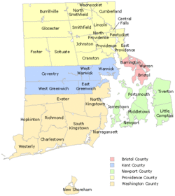
Rhode Island is a state located in Northeastern United States. According to the 2010 United States Census, Rhode Island is the 8th least populous state with 1,052,567 inhabitants and the smallest by land area spanning 1,033.81 square miles (2,677.6 km2) of land.[1] Rhode Island is divided into 5 counties and contains 39 incorporated municipalities consisting of cities and towns.[2] Towns in Rhode Island can adopt a city form of government without the need to re-incorporate as a city. Eight of these municipalities were re-incorporated as cities, while the other 31 remain as towns. Rhode Island has no county level of government and thus no county seats.
The largest municipality by population in Rhode Island is Providence, the state capital, with 178,042 residents, and the smallest municipality by population is New Shoreham with 1,051 residents.[1] Rhode Island is one of only two states (with Hawaii) in which all of the incorporated municipalities have a population greater than 1,000 people.[1] The largest municipality by land area is Coventry which spans 59.05 sq mi (152.9 km2), while Central Falls is the smallest at 1.20 sq mi (3.1 km2).[1]
List of municipalities
- Largest municipalities in Rhode Island by population
-
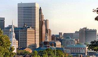
Downtown Providence, the capital and most populous city in Rhode Island
-
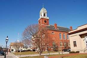
City Hall of Warwick, the second most populous city in Rhode Island
-
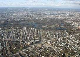
Aerial view of Cranston, the third most populous city in Rhode Island
-
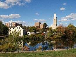
Downtown Pawtucket, the fourth most populous city in Rhode Island
| Name[3] | Type[1] | County[1] | Date incorporated[4] | Form of government[3] | Population (2010)[1] |
Population (2000)[1] |
Change (%) | Land area (2010)[1] |
Density | |
|---|---|---|---|---|---|---|---|---|---|---|
| sq mi | km2 | |||||||||
| Barrington | Town | Bristol | 1770 | Council-manager | 16,310 | 16,819 | −3.0% | 8.22 | 21.3 | 1,984.2/sq mi (766.1/km2) |
| Bristol | Town | Bristol | 1747[5] | Council-manager | 22,954 | 22,469 | +2.2% | 9.82 | 25.4 | 2,337.5/sq mi (902.5/km2) |
| Burrillville | Town | Providence | 1806 | Council-manager | 15,955 | 15,796 | +1.0% | 55.03 | 142.5 | 289.9/sq mi (111.9/km2) |
| Central Falls | City | Providence | 1895[6] | Mayor-council | 19,376 | 18,928 | +2.4% | 1.20 | 3.1 | 16,146.7/sq mi (6,234.3/km2) |
| Charlestown[7] | Town | Washington | 1738 | Council-manager | 7,827 | 7,859 | −0.4% | 36.45 | 94.4 | 214.7/sq mi (82.9/km2) |
| Coventry | Town | Kent | 1741 | Council-manager | 35,014 | 33,668 | +4.0% | 59.05 | 152.9 | 593.0/sq mi (228.9/km2) |
| Cranston | City | Providence | 1754 | Mayor-council | 80,387 | 79,269 | +1.4% | 28.34 | 73.4 | 2,836.5/sq mi (1,095.2/km2) |
| Cumberland | Town | Providence | 1747[5] | Mayor-council | 33,506 | 31,840 | +5.2% | 26.45 | 68.5 | 1,266.8/sq mi (489.1/km2) |
| East Greenwich | Town | Kent | 1677 | Council-manager | 13,146 | 12,948 | +1.5% | 16.39 | 42.4 | 802.1/sq mi (309.7/km2) |
| East Providence | City | Providence | 1862[5] | Council-manager | 47,037 | 48,688 | −3.4% | 13.24 | 34.3 | 3,552.6/sq mi (1,371.7/km2) |
| Exeter | Town | Washington | 1743 | Town meeting | 6,425 | 6,045 | +6.3% | 57.47 | 148.8 | 111.8/sq mi (43.2/km2) |
| Foster | Town | Providence | 1781 | Town meeting | 4,606 | 4,274 | +7.8% | 50.80 | 131.6 | 90.7/sq mi (35.0/km2) |
| Glocester | Town | Providence | 1730 | Town meeting | 9,746 | 9,948 | −2.0% | 54.18 | 140.3 | 179.9/sq mi (69.5/km2) |
| Hopkinton | Town | Washington | 1757 | Town meeting | 8,188 | 7,836 | +4.5% | 42.95 | 111.2 | 190.6/sq mi (73.6/km2) |
| Jamestown | Town | Newport County | 1678 | Council-manager | 5,405 | 5,622 | −3.9% | 9.45 | 24.5 | 572.0/sq mi (220.8/km2) |
| Johnston | Town | Providence | 1759 | Mayor-council | 28,769 | 28,195 | +2.0% | 23.43 | 60.7 | 1,227.9/sq mi (474.1/km2) |
| Lincoln | Town | Providence | 1871[6] | Council-manager | 21,105 | 20,898 | +1.0% | 18.12 | 46.9 | 1,164.7/sq mi (449.7/km2) |
| Little Compton | Town | Newport | 1747[5] | Town meeting | 3,492 | 3,593 | −2.8% | 20.52 | 53.1 | 170.2/sq mi (65.7/km2) |
| Middletown | Town | Newport | 1743 | Council-manager | 16,150 | 17,334 | −6.8% | 12.72 | 32.9 | 1,269.7/sq mi (490.2/km2) |
| Narragansett | Town | Washington | 1901[6] | Council-manager | 15,868 | 16,361 | −3.0% | 13.89 | 36.0 | 1,142.4/sq mi (441.1/km2) |
| Newport | City | Newport | 1639 | Council-manager | 24,672 | 26,475 | −6.8% | 7.67 | 19.9 | 3,216.7/sq mi (1,242.0/km2) |
| New Shoreham | Town | Washington | 1672 | Council-manager | 1,051 | 1,010 | +4.1% | 9.08 | 23.5 | 115.7/sq mi (44.7/km2) |
| North Kingstown | Town | Washington | 1674 | Council-manager | 26,486 | 26,326 | +0.6% | 43.14 | 111.7 | 614.0/sq mi (237.0/km2) |
| North Providence | Town | Providence | 1765 | Mayor-council | 32,078 | 32,411 | −1.0% | 5.62 | 14.6 | 5,707.8/sq mi (2,203.8/km2) |
| North Smithfield | Town | Providence | 1871[6] | Council-manager | 11,967 | 10,618 | +12.7% | 23.80 | 61.6 | 502.8/sq mi (194.1/km2) |
| Pawtucket | City | Providence | 1862[5] | Mayor-council | 71,148 | 72,958 | −2.5% | 8.68 | 22.5 | 8,196.8/sq mi (3,164.8/km2) |
| Portsmouth | Town | Newport | 1638 | Council-manager | 17,389 | 17,149 | +1.4% | 22.98 | 59.5 | 756.7/sq mi (292.2/km2) |
| Providence | City | Providence | 1636 | Mayor-council | 178,042 | 173,618 | +2.5% | 18.40 | 47.7 | 9,676.2/sq mi (3,736.0/km2) |
| Richmond | Town | Washington | 1747 | Town meeting | 7,708 | 7,222 | +6.7% | 40.29 | 104.4 | 191.3/sq mi (73.9/km2) |
| Scituate | Town | Providence | 1730 | Town meeting | 10,329 | 10,324 | 0.0% | 48.16 | 124.7 | 214.5/sq mi (82.8/km2) |
| Smithfield | Town | Providence | 1730 | Council-manager | 21,430 | 20,613 | +4.0% | 26.31 | 68.1 | 814.5/sq mi (314.5/km2) |
| South Kingstown | Town | Washington | 1723 | Council-manager | 30,639 | 27,921 | +9.7% | 56.45 | 146.2 | 542.8/sq mi (209.6/km2) |
| Tiverton | Town | Newport | 1747[5] | Town meeting | 15,780 | 15,260 | +3.4% | 29.05 | 75.2 | 543.2/sq mi (209.7/km2) |
| Warren | Town | Bristol | 1747[5] | Council-manager | 10,611 | 11,360 | −6.6% | 6.12 | 15.9 | 1,733.8/sq mi (669.4/km2) |
| Warwick | City | Kent | 1642[8] | Mayor-council | 82,672 | 85,808 | −3.7% | 35.04 | 90.8 | 2,359.4/sq mi (911.0/km2) |
| Westerly | Town | Washington | 1669 | Council-manager | 22,787 | 22,966 | −0.8% | 29.52 | 76.5 | 771.9/sq mi (298.0/km2) |
| West Greenwich | Town | Kent | 1741 | Town meeting | 6,135 | 5,085 | +20.6% | 50.26 | 130.2 | 122.1/sq mi (47.1/km2) |
| West Warwick | Town | Kent | 1913[9] | Council-manager | 29,191 | 29,581 | −1.3% | 7.79 | 20.2 | 3,747.2/sq mi (1,446.8/km2) |
| Woonsocket | City | Providence | 1867[6] | Mayor-council | 41,186 | 43,224 | −4.7% | 7.74 | 20.0 | 5,321.2/sq mi (2,054.5/km2) |
| Total | — | — | — | — | 1,052,567 | 1,048,319 | +0.4% | 1,033.82 | 2,677.6 | 1,018.13/sq mi (393.10/km2) |
See also
Notes and references
- 1 2 3 4 5 6 7 8 9 "GCT-PH1 – Population, Housing Units, Area, and Density: 2010 – State — Place and (in selected states) County Subdivision". 2010 United States Census. United States Census Bureau. Retrieved June 17, 2016.
- ↑ "Rhode Island: 2010 Population and Housing Unit Counts 2010 Census of Population and Housing" (PDF). 2010 United States Census. United States Census Bureau. September 2012. p. 18. Retrieved June 17, 2016.
- 1 2 "State and Community Profiles". Rhode Island Economic Development Corporation. Retrieved 2009-07-21.
- ↑ Snow, Edwin M. (1865). Report Upon the Census of Rhode Island, 1865: With the Statistics of the Population, Agriculture, Fisheries and Manufactures of the State. University of Michigan. Rhode Island Census Board. p. xxvii.
- 1 2 3 4 5 6 7 Refers to date the town was formally annexed by Rhode Island from Massachusetts
- 1 2 3 4 5 Clarence Saunders Brigham, Frank Greene Bates (1904). Report on the Archives of Rhode Island. G.P.O. p. 643.
- ↑ Charlestown, Richmond, and Hopkinton are often collectively referred to as Chariho, the name given to their regional school district in 1958.
- ↑ Town was organized in 1647
- ↑ Town of West Warwick
External links
- Complete List of all 39 Towns and Cities in RI (ri.gov)
- State and Community Profiles from the Rhode Island Economic Development Corporation includes interactive map of town and city boundaries.
Providence (capital) | |
| Topics |
|
| Society |
|
| Regions | |
| Cities | |
| Towns |
|