| Name | Location | Coordinates | Image | Focal
Height | Built[note 1] | Automated | Deactivated | Status |
|---|
| Assateague Light | Assateague Island | 37°54′40″N 75°21′21″W / 37.9111°N 75.3558°W / 37.9111; -75.3558 | 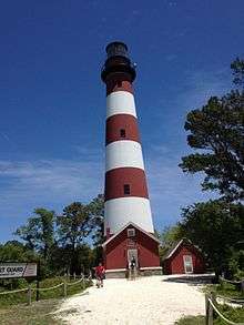 | 142 142 ft (43 m) | 1867 | 1933 | | Active |
| Back River Light | Chesapeake Bay near Hampton | 37°05′14″N 76°16′11″W / 37.0872°N 76.2698°W / 37.0872; -76.2698 |  | 030 30 ft (9.1 m) | 1829 | | 1936 | Destroyed |
| Bells Rock Light | York River | 37°29′02″N 76°44′59″W / 37.4839°N 76.7498°W / 37.4839; -76.7498 |  | 040 40 ft (12 m) | 1881 | 1928 | | replaced with skel. tower |
| Bowlers Rock Light | Rappahannock River | 37°49′28″N 76°43′58″W / 37.8245°N 76.7327°W / 37.8245; -76.7327 |  | | 1868 | | 1920 | replaced with caisson light |
| Cape Charles Light | Cape Charles | 37°07′22″N 75°54′23″W / 37.1229°N 75.9063°W / 37.1229; -75.9063 |  | 180 180 ft (55 m) | 1828/1895 | 1963 | | Active |
| Cape Henry Light (old) | Cape Henry, Virginia Beach | 36°55′33″N 76°00′29″W / 36.9257°N 76.0081°W / 36.9257; -76.0081 |  | | 1792 | | 1881 | Inactive |
| Cape Henry Light (new) | Cape Henry, Virginia Beach | 36°55′35″N 76°00′26″W / 36.9264°N 76.0072°W / 36.9264; -76.0072 |  | 164 164 ft (50 m) | 1881 | 1984 | | Active |
| Cherrystone Bar Light | SW of Cape Charles | 37°15′23″N 76°01′57″W / 37.2564°N 76.0324°W / 37.2564; -76.0324 |  | | 1858 | | 1919 | Moved to Choptank River Light;
replaced with caisson light |
| Chesapeake Light | entrance to Chesapeake Bay | 36°54′17″N 75°42′46″W / 36.90472°N 75.71278°W / 36.90472; -75.71278 |  | 120 120 ft (37 m) | 1965 | 1980 | | Active |
| Craney Island Light | mouth of Elizabeth River | 36°53′31″N 76°20′13″W / 36.892°N 76.337°W / 36.892; -76.337 |  | 036 36 ft (11 m) | 1859/1884 | | 1936 | replaced with buoy |
| Deepwater Shoals Light | James River | 37°8′11.46″N 76°38′12.48″W / 37.1365167°N 76.6368000°W / 37.1365167; -76.6368000 |  | 027 27 ft (8.2 m) | 1855 | | 1936 | replaced with skel. tower |
| Dutch Gap Canal Lights | James River | 37°22′35″N 77°21′34″W / 37.37639°N 77.35944°W / 37.37639; -77.35944 | | 027 27 ft (8.2 m) | 1875 | | 1910 | replaced with skel. towers |
| Great Wicomico River Light | Chesapeake Bay | 37°48′15″N 76°16′03″W / 37.8042°N 76.2675°W / 37.8042; -76.2675 |  | 042 42 ft (13 m) | 1889 | 1967 | | replaced with skel. tower |
| Hog Island Light | Hog Island near Exmore, Virginia | 37°23′38″N 75°42′04″W / 37.394°N 75.701°W / 37.394; -75.701 | 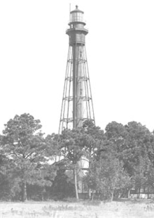 | | 1853/1896 | | 1948 | Demolished |
| Jones Point Light | Alexandria | 38°47′25.4″N 77°02′26.3″W / 38.790389°N 77.040639°W / 38.790389; -77.040639 |  | | 1856 | 1919 | 1926 | supplanted by skel. tower;
Standing but inactive[note 2] |
| Jordan Point Light | James River | 37°18′47″N 77°13′23″W / 37.313°N 77.223°W / 37.313; -77.223 |  | 035 35 ft (11 m) | 1856/1875 | | 1927 | Replaced by skel. tower in 1941 |
| Killock Shoal Light | West of Chincoteague, Virginia | 37°56′02″N 75°22′48″W / 37.934°N 75.380°W / 37.934; -75.380 | 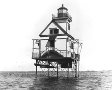 | 048 48 ft (15 m) | 1886 | 1929 | 1939 | Replaced by skel. tower in 1941;
now unlit |
| Lambert Point Light | Norfolk | 36°52′30″N 76°19′52″W / 36.875°N 76.331°W / 36.875; -76.331 |  | | 1872 | | 1892 | Collapsed around 1911 |
| Nansemond River Light | Nansemond and James rivers | 36°54′43″N 76°26′42″W / 36.912°N 76.445°W / 36.912; -76.445 |  | | 1878 | | 1935 | Removed ca. 1980 |
| New Point Comfort Light | Chesapeake Bay | 36°54′43″N 76°26′42″W / 36.912°N 76.445°W / 36.912; -76.445 | 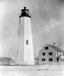 | 058 58 ft (18 m) | 1804 | 1930 | 1963 | Inactive |
| Newport News Middle Ground Light | Newport News | 36°56′43″N 76°23′29″W / 36.9452°N 76.3915°W / 36.9452; -76.3915 |  | 070 70 ft (21 m) | 1891 | 1954 | | Active |
| Old Plantation Flats Light | Cape Charles | 37°13′44″N 76°02′49″W / 37.2288°N 76.0469°W / 37.2288; -76.0469 |  | 035 35 ft (11 m) | 1886 | | 1962 | replaced with skel. tower |
| Old Point Comfort Light | Hampton | 37°00′06″N 76°18′23″W / 37.0018°N 76.3064°W / 37.0018; -76.3064 | 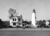 | 058 58 ft (18 m) | 1802 | 1972 | | active |
| Pages Rock Light | York River | 37°18′39″N 76°35′12″W / 37.3109°N 76.5866°W / 37.3109; -76.5866 |  | 043 43 ft (13 m) | 1893 | 1960 | 1967 | removed |
| Point of Shoals Light | James River | 37°04′06″N 76°39′11″W / 37.0683°N 76.6530°W / 37.0683; -76.6530 |  | | 1855/1871 | 1932 | 1933 | house removed |
| Pungoteague Creek Light | Chesapeake Bay | 37°39′47″N 75°53′53″W / 37.6630°N 75.8980°W / 37.6630; -75.8980 | | | 1854 | | 1856 | replaced with automated caisson light |
| Smith Point Light | mouth of Potomac River | 37°52′48″N 76°11′02″W / 37.8800°N 76.1839°W / 37.8800; -76.1839 |  | 052 52 ft (16 m) | 1802/1897 | 1971 | | active |
| Stingray Point Light | mouth of Rappahannock River | 37°33′41″N 76°16′12″W / 37.5613°N 76.2700°W / 37.5613; -76.2700 |  | 034 34 ft (10 m) | 1858 | 1965 | 1965 | replaced with skel. tower |
| Tangier Sound Light | Chesapeake Bay | 37°47′16″N 75°58′26″W / 37.7878°N 75.9740°W / 37.7878; -75.9740 |  | 045 45 ft (14 m) | 1890 | | 1961 | replaced with skel. tower |
| Thimble Shoal Light | Chesapeake Bay, north of Hampton Roads | 37°00′53″N 76°14′24″W / 37.0146°N 76.2399°W / 37.0146; -76.2399 |  | 052 52 ft (16 m) | 1872/1914 | 1964 | | active |
| Tue Marshes Light | mouth of York River | 37°14′08″N 76°23′09″W / 37.2356°N 76.3859°W / 37.2356; -76.3859 |  | 041 41 ft (12 m) | 1875 | | 1960 | replaced with skel. tower |
| Watts Island Light | Chesapeake Bay | 37°46′55″N 75°53′38″W / 37.782°N 75.894°W / 37.782; -75.894 |  | 048 48 ft (15 m) | 1833 | 1923 | 1944 | destroyed |
| White Shoal Light | James River | 37°01′18″N 76°31′39″W / 37.0218°N 76.5275°W / 37.0218; -76.5275 |  | | 1855/1871 | | 1934 | house destroyed by ice in the 1970s;
foundation survives |
| Windmill Point Light | mouth of Rappahannock River | 37°35′48″N 76°14′09″W / 37.5968°N 76.2359°W / 37.5968; -76.2359 |  | 036 36 ft (11 m) | 1869 | | 1965 | replaced with skel. tower |
| Wolf Trap Light | Chesapeake Bay | 37°35′48″N 76°14′09″W / 37.5968°N 76.2359°W / 37.5968; -76.2359 |  | 052 52 ft (16 m) | 1870/1894 | 1971 | | active |
| York Spit Light | mouth of York River | 37°12′35″N 76°15′15″W / 37.2096°N 76.2542°W / 37.2096; -76.2542 |  | | 1870 | | 1960 | replaced with post light |