List of largest volcanic eruptions

In a volcanic eruption, lava, tephra (volcanic bombs, lapilli, and ash), and various gases are expelled from a volcanic vent or fissure. While many eruptions only pose dangers to the immediately surrounding area, Earth's largest eruptions can have a major regional or even global impact, with some affecting the climate and contributing to mass extinctions.[1][2] Volcanic eruptions can generally be characterized as either explosive eruptions, sudden ejections of rock and ash, or effusive eruptions, relatively gentle outpourings of lava.[3] A separate list is given below for each type.
All of the eruptions listed below have produced at least 1,000 km3 (240 cu mi) of lava and tephra; for explosive eruptions, this corresponds to a Volcanic Explosivity Index (or VEI) of 8.[4] They are at least a thousand times larger than the 1980 eruption of Mount St. Helens, which produced only 1 km3 (0.2 cu mi) of material,[5] and at least six times larger than the 1815 eruption of Mount Tambora, the largest eruption in recent history, which produced 160 km3 (38 cu mi) of volcanic deposits.
There have probably been many such eruptions during Earth's history beyond those shown in these lists. However erosion and plate tectonics have taken their toll, and many eruptions have not left enough evidence for geologists to establish their size. Even for the eruptions listed here, estimates of the volume erupted can be subject to considerable uncertainty.[6]
Explosive eruptions
In explosive eruptions, the eruption of magma is driven by the rapid release of pressure, often involving the explosion of gas previously dissolved within the material. The most famous and destructive historical eruptions are mainly of this type. An eruptive phase can consist of a single eruption, or a sequence of several eruptions spread over several days, weeks or months. Explosive eruptions usually involve thick, highly viscous, silicic or felsic magma, high in volatiles like water vapor and carbon dioxide. Pyroclastic materials are the primary product, typically in the form of tuff. Eruptions the size of that at Lake Toba 74,000 years ago, at least 2,800 cubic kilometres (670 cu mi), or the Yellowstone eruption 620,000 years ago, around 1,000 cubic kilometres (240 cu mi), occur worldwide every 50,000 to 100,000 years.[1][n 1]
| Volcano—eruption[7] | Age (Millions of years)[n 2] | Location | Volume (km3)[n 3] | Notes | Refs |
|---|---|---|---|---|---|
| Guarapuava —Tamarana—Sarusas | 132 | Paraná and Etendeka traps | 8,600 | Existence as a single volcano is controversial. Possibly a volcano chain.[6] | [6] |
| Santa Maria—Fria | ~132 | Paraná and Etendeka traps | 7,800 | Existence as a single volcano is controversial. Possibly a volcano chain.[6] | [6] |
| Guarapuava —Ventura | ~132 | Paraná and Etendeka traps | 7,600 | Existence as a single volcano is controversial. Possibly a volcano chain.[6] | [6] |
| Sam Ignimbrite and Green Tuff | 29.5 | Yemen | 6,800 | Volume includes 5550 km³ of distal tuffs. This estimate is uncertain to a factor of 2 or 3. | [8] |
| Goboboseb–Messum volcanic centre—Springbok quartz latite unit | 132 | Paraná and Etendeka traps, Brazil and Namibia | 6,340 | [9] | |
| Caxias do Sul—Grootberg | ~132 | Paraná and Etendeka traps | 5,650 | [6] | |
| La Garita Caldera—Fish Canyon Tuff | 27.8 | San Juan volcanic field, Colorado | 5,000 | Part of at least 20 large caldera-forming eruptions in the San Juan volcanic field and surrounding area that formed around 26 to 35 Ma. | [10][11] |
| Jacui—Goboboseb II | ~132 | Paraná and Etendeka traps | 4,350 | [6] | |
| Ourinhos—Khoraseb | ~132 | Paraná and Etendeka traps | 3,900 | [6] | |
| Jabal Kura'a Ignimbrite | 29.6 | Yemen | 3,800 | Volume estimate is uncertain to a factor of 2 or 3. | [8] |
| Windows Butte tuff | 31.4 | William's Ridge, central Nevada | 3,500 | Part of the Mid-Tertiary ignimbrite flare-up | [12][13] |
| Anita Garibaldi—Beacon | ~132 | Paraná and Etendeka traps | 3,450 | [6] | |
| Indian Peak Caldera Complex—Wah Wah Springs tuff | 29.5 | Eastern Nevada/Western Utah | 3,200 | Indian Peak Caldera Complex total volume over 10,000 cubic km, Wah Wah Springs tuff being the largest | [14][15] |
| Oxaya ignimbrites | 19 | Chile | 3,000 | Really a regional correlation of many ignimbrites originally thought to be distinct | [16] |
| Lund Tuff | 29 | Great Basin, USA | 3,000 | Similar in composition to the Fish Canyon Tuff | [17] |
| Lake Toba—Youngest Toba Tuff | 0.073 | Sunda Arc, Indonesia | 2,800 | Largest known eruption on earth in at least the last 25 million years, responsible for a population bottleneck of the human species (see Toba catastrophe theory) | [18] |
| Pacana Caldera—Atana ignimbrite | 4 | Chile | 2,800 | Forms a resurgent caldera. | [19] |
| Iftar Alkalb—Tephra 4 W | 29.5 | Afro-Arabian | 2,700 | [6] | |
| Yellowstone Caldera—Huckleberry Ridge Tuff | 2.059 | Yellowstone hotspot | 2,450 | Largest Yellowstone eruption on record | [20] |
| Whakamaru | 0.254 | Taupo Volcanic Zone, New Zealand | 2,000 | Largest in the Southern Hemisphere in the Late Quaternary | [21] |
| Palmas BRA-21—Wereldsend | 29.5 | Paraná and Etendeka traps | 1,900 | [6] | |
| Kilgore tuff | 4.3 | Near Kilgore, Idaho | 1,800 | Last of the eruptions from the Heise volcanic field | [22] |
| Sana'a Ignimbrite—Tephra 2W63 | 29.5 | Afro-Arabian | 1,600 | [6] | |
| Millbrig eruptions—Bentonites | 454 | England, exposed in Northern Europe and Eastern US | 1,509[n 4] | One of the oldest large eruptions preserved | [7][23][24] |
| Blacktail tuff | 6.5 | Blacktail, Idaho | 1,500 | First of several eruptions from the Heise volcanic field | [22] |
| Emory Caldera—Kneeling Nun tuff | 33 | Southwestern New Mexico | 1,310 | [25] | |
| Timber Mountain tuff | 11.6 | Southwestern Nevada | 1,200 | Also includes a 900 cubic km tuff as a second member in the tuff | [26] |
| Paintbrush tuff (Topopah Spring Member) | 12.8 | Southwestern Nevada | 1,200 | Related to a 1000 cubic km tuff (Tiva Canyon Member) as another member in the Paintbrush tuff | [26] |
| Bachelor—Carpenter Ridge tuff | 28 | San Juan volcanic field | 1,200 | Part of at least 20 large caldera-forming eruptions in the San Juan volcanic field and surrounding area that formed around 26 to 35 Ma | [11] |
| Bursum—Apache Springs Tuff | 28.5 | Southern New Mexico | 1,200 | Related to a 1050 cubic km tuff, the Bloodgood Canyon tuff | [27] |
| Taupo Volcano—Oruanui eruption | 0.027 | Taupo Volcanic Zone, New Zealand | 1,170 | Most recent VEI 8 eruption | [28] |
| Huaylillas Ignimbrite | 15 | Bolivia | 1,100 | Predates half of the uplift of the central Andes | [29] |
| Bursum—Bloodgood Canyon tuff | 28.5 | Southern New Mexico | 1,050 | Related to a 1200 cubic km tuff, the Apache Springs tuff | [27] |
| Yellowstone Caldera—Lava Creek Tuff | 0.639 | Yellowstone hotspot | 1,000 | Last large eruption in the Yellowstone National Park area | [30] |
| Cerro Galán | 2.2 | Catamarca Province, Argentina | 1,000 | Elliptical caldera is ~35 km wide | [31] |
| Paintbrush tuff (Tiva Canyon Member) | 12.7 | Southwestern Nevada | 1,000 | Related to a 1200 cubic km tuff (Topopah Spring Member) as another member in the Paintbrush tuff | [26] |
| San Juan—Sapinero Mesa Tuff | 28 | San Juan volcanic field | 1,000 | Part of at least 20 large caldera-forming eruptions in the San Juan volcanic field and surrounding area that formed around 26 to 35 Ma | [11] |
| Uncompahgre—Dillon & Sapinero Mesa Tuffs | 28.1 | San Juan volcanic field | 1,000 | Part of at least 20 large caldera-forming eruptions in the San Juan volcanic field and surrounding area that formed around 26 to 35 Ma | [11] |
| Platoro—Chiquito Peak tuff | 28.2 | San Juan volcanic field | 1,000 | Part of at least 20 large caldera-forming eruptions in the San Juan volcanic field and surrounding area that formed around 26 to 35 Ma | [11] |
| Mount Princeton—Wall Mountain tuff | 35.3 | Thirtynine Mile volcanic area, Colorado | 1,000 | Helped cause the exceptional preservation at Florissant Fossil Beds National Monument | [32] |
Effusive eruptions
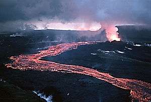
Effusive eruptions involve a relatively gentle, steady outpouring of lava rather than large explosions. They can continue for years or decades, producing extensive fluid mafic lava flows.[33] For example, Kīlauea on Hawaiʻi has continued erupting from 1983 to the present, producing 2.7 km3 (1 cu mi) of lava covering more than 100 km2 (40 sq mi).[34] Despite their ostensibly benign appearance, effusive eruptions are no less dangerous than explosive ones: one of the largest effusive eruptions in history occurred in Iceland during the 1783–1784 eruption of Laki, which produced about 15 km3 (4 cu mi) of lava and killed one fifth of Iceland's population.[33] The ensuing disruptions to the climate may also have killed millions elsewhere.[35] Still larger were the eruptions of Katla (the Eldgjá eruption) circa 934, with 18 km3 (4 cu mi) of erupted lava, and the Þjórsárhraun eruption of Bárðarbunga circa 6700 BC, with 25 km3 (6 cu mi) lava erupted, the latter being the largest effusive eruption in the last 10.000 years.[36] The lava fields of these eruptions measure 565 km2 (Laki), 700 km2 (Eldgjá) and 950 km2 (Þjórsárhraun).
| Eruption | Age (Millions of years) | Location | Volume (km3) |
Notes | Refs |
|---|---|---|---|---|---|
| Mahabaleshwar–Rajahmundry Traps (Upper) | 64.8 | Deccan Traps, India | 9,300 | [6] | |
| Wapshilla Ridge flows | ~15.5 | Columbia River Basalt Group, United States | 5,000–10,000 | Member comprises 8–10 flows with a total volume of ~50,000 km3 | [37] |
| McCoy Canyon flow | 15.6 | Columbia River Basalt Group, United States | 4,300 | [37] | |
| Umtanum flows | ~15.6 | Columbia River Basalt Group, United States | 2,750 | Two flows with a total volume of 5,500 km3 | [6] |
| Sand Hollow flow | 15.3 | Columbia River Basalt Group, United States | 2,660 | [6] | |
| Pruitt Draw flow | 16.5 | Columbia River Basalt Group, United States | 2,350 | [37] | |
| Museum flow | 15.6 | Columbia River Basalt Group, United States | 2,350 | [37] | |
| Moonaree Dacite | 1591 | Gawler Range Volcanics, Australia | 2,050 | One of the oldest large eruptions preserved | [6] |
| Rosalia flow | 14.5 | Columbia River Basalt Group, United States | 1,900 | [6] | |
| Joseph Creek flow | 16.5 | Columbia River Basalt Group, United States | 1,850 | [37] | |
| Ginkgo Basalt | 15.3 | Columbia River Basalt Group, United States | 1,600 | [6] | |
| California Creek–Airway Heights flow | 15.6 | Columbia River Basalt Group, United States | 1,500 | [37] | |
| Stember Creek flow | 15.6 | Columbia River Basalt Group, United States | 1,200 | [37] |
Large igneous provinces
Highly active periods of volcanism in what are called large igneous provinces have produced huge oceanic plateaus and flood basalts in the past. These can comprise hundreds of large eruptions, producing millions of cubic kilometers of lava in total. No large eruptions of flood basalts have occurred in human history, the most recent having occurred over 10 million years ago. They are often associated with breakup of supercontinents such as Pangea in the geologic record,[38] and may have contributed to a number of mass extinctions. Most large igneous provinces have either not been studied thoroughly enough to establish the size of their component eruptions, or are not preserved well enough to make this possible. Many of the eruptions listed above thus come from just two large igneous provinces: the Paraná and Etendeka traps and the Columbia River Basalt Group. The latter is the most recent large igneous province, and also one of the smallest.[35] A list of large igneous provinces follows to provide some indication of how many large eruptions may be missing from the lists given here.
| Igneous province | Age (Millions of years) | Location | Volume (millions of km3) | Notes | Refs |
|---|---|---|---|---|---|
| Ontong Java–Manihiki–Hikurangi Plateau | 121 | Southwest Pacific Ocean | 59–77[n 5] | Largest igneous body on Earth, later split into three widely separated oceanic plateaus, with a fourth component perhaps now accreted onto South America. Possibly linked to the Louisville hotspot. | [39][40][41] |
| Kerguelen Plateau–Broken Ridge | 112 | South Indian Ocean, Kerguelen Islands | 17[n 5] | Linked to the Kerguelen hotspot. Volume includes Broken Ridge and the Southern and Central Kerguelen Plateau (produced 120–95 Ma), but not the Northern Kerguelen Plateau (produced after 40 Ma). | [42][43] |
| North Atlantic Igneous Province | 55.5 | North Atlantic Ocean | 6.6[n 6] | Linked to the Iceland hotspot. | [7][44] |
| Mid-Tertiary ignimbrite flare-up | 32.5 | Southwest United States: mainly in Colorado, Nevada, Utah, and New Mexico | 5.5 | Mostly andesite to rhyolite explosive (.5 million km3) to effusive (5 million km3) eruptions, 25–40 Ma. Includes many volcanic centers, including the San Juan volcanic field. | [45] |
| Caribbean large igneous province | 88 | Caribbean–Colombian oceanic plateau | 4 | Linked to the Galápagos hotspot. | [46] |
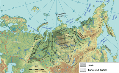
| Siberian Traps | 249.4 | Siberia, Russia | 1–4 | A large outpouring of lava on land, believed to have caused the Permian–Triassic extinction event, the largest mass extinction ever. | [47] |
| Karoo-Ferrar | 183 | Mainly Southern Africa and Antarctica. Also South America, India, Australia and New Zealand | 2.5 | Formed as Gondwana broke up | [48] |
| Paraná and Etendeka traps | 133 | Brazil/Angola and Namibia | 2.3 | Linked to the Tristan hotspot | [49][50] |
| Central Atlantic magmatic province | 200 | Laurasia continents | 2 | Formed as Pangaea broke up | [51] |
| Deccan Traps | 66 | Deccan Plateau, India | 1.5 | May have helped kill the dinosaurs. | [52][53] |
| Emeishan Traps | 256.5 | Southwestern China | 1 | Along with Siberian Traps, may have contributed to the Permian–Triassic extinction event. | [54] |
| Coppermine River Group | 1267 | Mackenzie Large Igneous Province/Canadian Shield | 0.65 | Consists of at least 150 individual flows. | [55] |
| Afro-Arabian flood volcanism | 28.5 | Ethiopia/Yemen/Afar, Arabian-Nubian Shield | 0.35 | Associated with silicic, explosive tuffs | [56][57] |
| Columbia River Basalt Group | 16 | Pacific Northwest, United States | 0.18 | Well exposed by Missoula Floods in the Channeled Scablands. | [58] |
See also
- Extinction event
- Lists of earthquakes
- List of impact craters on Earth
- Supervolcano#Massive explosive eruptions
- Types of eruptions
- List of Flood basalt provinces
Notes
- ↑ Certain felsic provinces, such as the Chon Aike province in Argentina and the Whitsunday igneous province of Australia are not included in this list since they are composed of many separate eruptions that have not been distinguished.
- ↑ Dates are an average of the range of dates of volcanics
- ↑ These volumes are estimated total volumes of tephra ejected. If the available sources only report a dense rock equivalent volume, the number is italicized but not converted into a tephra volume.
- ↑ Also the site of 972 and 943 km3 (233 and 226 cu mi) eruptions.
- 1 2 This is the volume of crustal thickening, so the figure includes intrusive as well as extrusive deposits.
- ↑ Actually several provinces, ranging in size from 1.5 to 6.6 million km3
References
- 1 2 Roy Britt, Robert (8 March 2005). "Super Volcano Will Challenge Civilization, Geologists Warn". LiveScience. Retrieved 27 August 2010.
- ↑ Self, Steve. "Flood basalts, mantle plumes and mass extinctions". Geological Society of London. Retrieved 27 August 2010.
- ↑ "Effusive & Explosive Eruptions". Geological Society of London. Retrieved 28 August 2010.
- ↑ "How Volcanoes Work: Eruption Variabilty". San Diego State University. Retrieved 3 August 2010.
- ↑ Edward W. Wolfe & Thomas C. Pierson (17 July 2002). "Report: Volcanic-Hazard Zonation for Mount St. Helens, Washington, 1995". U.S. Geological Survey Open-File Report 95-497. USGS. Retrieved 27 August 2010.
- 1 2 3 4 5 6 7 8 9 10 11 12 13 14 15 16 17 18 19 20 Scott E. Bryan; Ingrid Ukstins Peate; David W. Peate; Stephen Self; Dougal A. Jerram; Michael R. Mawby; J.S. Marsh; Jodie A. Miller (2010). "The largest volcanic eruptions on Earth". Earth-Science Reviews. 102: 207. Bibcode:2010ESRv..102..207B. doi:10.1016/j.earscirev.2010.07.001.
- 1 2 3 (Data in this table are from Ward (2009) unless noted otherwise) Ward, Peter L. (2 April 2009). "Sulfur Dioxide Initiates Global Climate Change in Four Ways" (PDF). Thin Solid Films. Elsevier B. V. 517 (11): 3188–3203. Bibcode:2009TSF...517.3188W. doi:10.1016/j.tsf.2009.01.005. Retrieved 2010-03-19. Supplementary Table I: "Supplementary Table to P.L. Ward, Thin Solid Films (2009) Major volcanic eruptions and provinces" (PDF). Teton Tectonics. Retrieved 8 September 2010. Supplementary Table II: "Supplementary References to P.L. Ward, Thin Solid Films (2009)" (PDF). Teton Tectonics. Retrieved 8 September 2010.
- 1 2 Ingrid Ukstins Peate; Joel A. Baker; Mohamed Al-Kadasi; Abdulkarim Al-Subbary; Kim B. Knight; Peter Riisager; Matthew F. Thirlwall; David W. Peate; Paul R. Renne; Martin A. Menzies (2005). "Volcanic stratigraphy of large-volume silicic pyroclastic eruptions during Oligocene Afro-Arabian flood volcanism in Yemen". Bulletin of Volcanology. Springer. 68: 135–156. Bibcode:2005BVol...68..135P. doi:10.1007/s00445-005-0428-4.
- ↑ Ewart, A.; Milner, S.C.; Armstrong, R.A.; Duncan, A.R. (1998). "Etendeka Volcanism of the Goboboseb Mountains and Messum Igneous Complex, Namibia. Part II: Voluminous Quartz Latite Volcanism of the Awahab Magma System". Journal of Petrology. 39 (2): 227–253. doi:10.1093/petrology/39.2.227. Retrieved 29 August 2010.
- ↑ Ort, Michael (22 September 1997). "La Garita Caldera". Northern Arizona University. Retrieved 5 August 2010.
- 1 2 3 4 5 Lipman, Peter W. (2007-11-02). "Geologic Map of the Central San Juan Caldera Cluster, Southwestern Colorado". USGS Investigations Series I-2799. Retrieved 6 August 2010.
- ↑ Cannon, Eric. "4. Petrology – The Mid-Tertiary Ignimbrite Flare-Up". University of Colorado at Boulder. Retrieved 5 August 2010.
- ↑ Best, Myron G.; Scott R. B.; Rowley P. D.; Swadley W. C.; Anderson R. E.; Grommé C. S.; Harding A. E.; Deino A. L.; Christiansen E. H.; Tingey D. G.; Sullivan K. R. (1993). "Oligocene–Miocene caldera complexes, ash-flow sheets, and tectonism in the central and southeastern Great Basin". Field Trip Guidebook for Cordilleran/Rocky Mountain Sections of the Geological Society of America. Crustal Evolution of the Great Basin and the Sierra Nevada: 285–312.
- ↑ Best, Myron G.; Eric H. Christiansen; Richard H. Blank, Jr (1989). "Oligocene caldera complex and calc-alkaline tuffs and lavas of the Indian Peak volcanic field, Nevada and Utah". GSA Bulletin. Geological Society of America. 101 (8): 1076–1090. Bibcode:1989GSAB..101.1076B. doi:10.1130/0016-7606(1989)101<1076:OCCACA>2.3.CO;2. Retrieved 5 August 2010.
- ↑ Woolf, Kurtus S. (2008). "Pre-Eruptive Conditions of the Oligocene Wah Wah Springs Tuff, Southeastern Great Basin Ignimbrite Province". Retrieved 18 August 2010.
- ↑ Wörner, Gerhard; Konrad Hammerschmidt; Friedhelm Henjes-Kunst; Judith Lezaun; Hans Wilke (2000). "Geochronology (40Ar/39Ar, K-Ar and He-exposure ages) of Cenozoic magmatic rocks from Northern Chile (18–22°S): implications for magmatism and tectonic evolution of the central Andes". Revista geológica de Chile. 27 (2). Retrieved 5 August 2010.
- ↑ Maughan, Larissa L.; Eric H. Christiansen; Myron G. Best; C. Sherman Grommé; Alan L. Deino; David G. Tingey (March 2002). "The Oligocene Lund Tuff, Great Basin, USA: a very large volume monotonous intermediate". Journal of Volcanology and Geothermal Research. 113 (1–2): 129–157. Bibcode:2002JVGR..113..129M. doi:10.1016/S0377-0273(01)00256-6. Retrieved 5 August 2010.
- ↑ Ambrose, Stanley H. (June 1998). "Late Pleistocene human population bottlenecks, volcanic winter, and differentiation of modern humans." (PDF). Journal of Human Evolution. Elsevier B. V. 34 (6): 623–651. doi:10.1006/jhev.1998.0219. PMID 9650103. Retrieved 5 August 2010.
- ↑ Lindsay, J. M.; S. de Silva; R. Trumbull; R. Emmermann; K. Wemmer (April 2001). "La Pacana caldera, N. Chile: a re-evaluation of the stratigraphy and volcanology of one of the world's largest resurgent calderas". Journal of Volcanology and Geothermal Research. Elsevier B. V. 106 (1–2): 145–173. Bibcode:2001JVGR..106..145L. doi:10.1016/S0377-0273(00)00270-5. Retrieved 23 August 2010.
- ↑ Topinka, Lyn (25 June 2009). "Description: Yellowstone Caldera, Wyoming". USGS. Retrieved 6 August 2010.
- ↑ Froggatt, P. C.; Nelson, C. S.; Carter, L.; Griggs, G.; Black, K. P. (13 February 1986). "An exceptionally large late Quaternary eruption from New Zealand". Nature. 319 (6054): 578–582. Bibcode:1986Natur.319..578F. doi:10.1038/319578a0. Retrieved 23 August 2010.
- 1 2 Morgan, Lisa A.; McIntosh, William C. (March 2005). "Timing and development of the Heise volcanic field, Snake River Plain, Idaho, western USA". GSA Bulletin. Geological Society of America. 117 (3–4): 288–306. Bibcode:2005GSAB..117..288M. doi:10.1130/B25519.1. Retrieved 22 August 2010.
- ↑ Stetten, Nancy. "Plate Tectonics from the Middle of the Plate". Retrieved 5 August 2010.
- ↑ Huff, W.D.; Bergstrom, S.M.; Kolata, D.R. (October 1992). "Gigantic Ordovician volcanic ash fall in North America and Europe: Biological, tectonomagmatic, and event-stratigraphy significance". Geology. Geological Society of America. 20 (10): 875–878. Bibcode:1992Geo....20..875H. doi:10.1130/0091-7613(1992)020<0875:GOVAFI>2.3.CO;2.
- ↑ Mason, Ben G.; Pyle, David M.; Oppenheimer, Clive (2004). "The size and frequency of the largest explosive eruptions on Earth". Bulletin of Volcanology. 66 (8): 735–748. Bibcode:2004BVol...66..735M. doi:10.1007/s00445-004-0355-9. Retrieved 20 September 2010.
- 1 2 3 Bindeman, Ilya N.; John W. Valley (May 2003). "Rapid generation of both high- and low-δ18O, large-volume silicic magmas at the Timber Mountain/Oasis Valley caldera complex, Nevada". GSA Bulletin. Geological Society of America. 115 (5): 581–595. Bibcode:2003GSAB..115..581B. doi:10.1130/0016-7606(2003)115<0581:RGOBHA>2.0.CO;2. Retrieved 18 August 2010.
- 1 2 Ratté, J. C.; R. F. Marvin; C. W. Naeser; M. Bikerman (27 January 1984). "Calderas and Ash Flow Tuffs of the Mogollon Mountains, Southwestern New Mexico". Journal of Geophysical Research. American Geophysical Union. 89 (B10): 8713–8732. Bibcode:1984JGR....89.8713R. doi:10.1029/JB089iB10p08713. Retrieved 18 August 2010.
- ↑ Wilson, Colin J. N.; Blake, S.; Charlier, B. L. A.; Sutton, A. N. (2006). "The 26.5 ka Oruanui Eruption, Taupo Volcano, New Zealand: Development, Characteristics and Evacuation of a Large Rhyolitic Magma Body". Journal of Petrology. 47 (1): 35–69. doi:10.1093/petrology/egi066.
- ↑ Thouret, J. C.; Wörner, G.; Singer, B.; Finizola, A. (April 6, 2003). "EGS-AGU-EUG Joint Assembly, held in Nice, France; chapter: Valley Evolution, Uplift, Volcanism, and Related Hazards in the Central Andes of Peru" (PDF): 641–644. Retrieved 5 August 2010.
- ↑ Morgan, Lisa (30 March 2004). "The floor of Yellowstone Lake is anything but quiet: Volcanic and hydrothermal processes in a large lake above a magma chamber". National Park Service and United States Geological Survey. Retrieved 5 August 2010.
- ↑ "How Volcanos Work: Cerro Galan". San Diego State University. Retrieved 5 August 2010.
- ↑ "Wall Mountain Tuff". National Park Service. Retrieved 5 August 2010.
- 1 2 "VHP Photo Glossary: Effusive Eruption". USGS. 29 December 2009. Retrieved 25 August 2010.
- ↑ Ruben, Ken (6 January 2008). "A Brief History of the Pu`u `O`o Eruption of Kilauea". SOEST. Retrieved 27 August 2010.
- 1 2 Frank Press & Raymond Siever (1978). "Volcanism". Earth (2nd ed.). San Francisco: W. F. Freeman and Company. pp. 348–378. ISBN 0-7167-0289-4.
- ↑ "Smithsonian Institution - Global Volcanism Program: Worldwide Holocene Volcano and Eruption Information". Volcano.si.edu. Retrieved 2015-12-16.
- 1 2 3 4 5 6 7 Martin, B. S.; Petcovic, H. L.; Reidel, S. P. (May 2005). "Goldschmidt Conference 2005: Field Trip Guide to the Columbia River Basalt Group" (PDF). Retrieved 1 September 2010.
- ↑ Coffin, Millard F.; Millard F. Coffin; Olav Eldholm (1994). "Large igneous provinces: Crustal structure, dimensions, and external consequences". Reviews of Geophysics. 32 (1): 1–36. Bibcode:1994RvGeo..32....1C. doi:10.1029/93RG02508. Retrieved 27 August 2010.
- ↑ T. Worthington; Tim J. Worthington; Roger Hekinian; Peter Stoffers; Thomas Kuhn; Folkmar Hauff (30 May 2006). "Osbourn Trough: Structure, geochemistry and implications of a mid-Cretaceous paleospreading ridge in the South Pacific". Earth and Planetary Science Letters. Elsevier B. V. 245 (3–4): 685–701. Bibcode:2006E&PSL.245..685W. doi:10.1016/j.epsl.2006.03.018. Retrieved 20 September 2010.
- ↑ Taylor, Brian (31 January 2006). "The single largest oceanic plateau: Ontong Java-Manihiki-Hikurangi" (PDF). Earth and Planetary Science Letters. Elsevier B. V. 241 (3–4): 372–380. Bibcode:2006E&PSL.241..372T. doi:10.1016/j.epsl.2005.11.049. Retrieved 20 September 2010.
- ↑ Kerr, Andrew C.; Mahoney, John J. (2007). "Oceanic plateaus: Problematic plumes, potential paradigms". Chemical Geology. 241: 332–353. doi:10.1016/j.chemgeo.2007.01.019.
- ↑ Weis, D.; Frey, F. A. "Kerguelen Plateau—Broken Ridge: A Major Lip Related to the Kerguelen Plume" (PDF). Seventh Annual V. M. Goldschmidt Conference. Retrieved 5 August 2010.
- ↑ Coffin, M.F.; Pringle, M.S.; Duncan, R.A.; Gladczenko, T.P.; Storey, M.; Müller, R.D.; Gahagan, L.A. (2002). "Kerguelen Hotspot Magma Output since 130 Ma". Journal of Petrology. 43 (7): 1121–1137. doi:10.1093/petrology/43.7.1121. Retrieved 9 September 2010.
- ↑ D. W. Jolley; B. R. Bell, eds. (2002). The North Atlantic Igneous Province: Stratigraphy, Tectonic, Volcanic and Magmatic Processes. Special Publication No. 197. Geological Society of London. ISBN 1-86239-108-4. ISSN 0305-8719.
- ↑ Cannon, Eric. "Introduction – The Mid-Tertiary Ignimbrite Flare-Up". Retrieved 9 September 2010.
- ↑ Hoernle, Kaj; Folkmar Hauff; Paul van den Bogaard (August 2004). "70 m.y. history (139–69 Ma) for the Caribbean large igneous province". Geology. Geological Society of America. 32 (8): 697–700. Bibcode:2004Geo....32..697H. doi:10.1130/G20574.1.
- ↑ Goodwin, Anna; Wyles, Jon & Morley, Alex (2001). "The Siberian Traps". Palaeobiology and Biodiversity Research Group, Department of Earth Sciences, University of Bristol. Retrieved 5 August 2010.
- ↑ Segev, A. (4 March 2002). "Flood basalts, continental breakup and the dispersal of Gondwana: evidence for periodic migration of upwelling mantle flows (plumes)" (PDF). European Geosciences Union Special Publication Series. 2: 171–191. Retrieved 5 August 2010.
- ↑ O'Neill, C.; Müller, R. D.; Steinberger, B. (2003). "Revised Indian plate rotations based on the motion of Indian Ocean hotspots" (PDF). Earth and Planetary Science Letters. Elsevier B. V. 215: 151–168. Bibcode:2003E&PSL.215..151O. doi:10.1016/S0012-821X(03)00368-6. Retrieved 20 September 2010.
- ↑ O'Connor, J. M.; le Roex, A. P. (1992). "South Atlantic hot spot-plume systems. 1: Distribution of volcanism in time and spac". Earth and Planetary Science Letters. Elsevier B. V. 113: 343–364. Bibcode:1992E&PSL.113..343O. doi:10.1016/0012-821X(92)90138-L.
- ↑ McHone, Greg. "CAMP site introduction". Auburn University. Retrieved 5 August 2010.
- ↑ "India's Smoking Gun: Dino-Killing Eruptions". Science Daily. 10 August 2005. Retrieved 5 August 2010.
- ↑ Chatterjee, Sankar; Mehrotra, Naresh M. (2009). "The Significance of the Contemporaneous Shiva Impact Structure and Deccan Volcanism at the KT Boundary". Abstracts with Programs. 2009 Annual Meeting of the Geological Society of America. 41 (7). Portland. p. 160. Retrieved 22 September 2010.
- ↑ Lo, Ching-Hua; Sun-Lin Chung; Tung-Yi Lee; Genyao Wu (2002). "Age of the Emeishan Flood magmatism and relations to Permian-Triassic boundary events" (PDF). Earth and Planetary Science Letters. Elsevier. 198: 449–458. Bibcode:2002E&PSL.198..449L. doi:10.1016/S0012-821X(02)00535-6. Retrieved 5 August 2010.
- ↑ Gittings, Fred W. (October 2008). Geological Report on the Muskox Property: Coppermine River Area, Nunavut (PDF). NTS 86 O/6. Retrieved 20 September 2010.
- ↑ Peate, Ingrid Ukstins; et al. (2005). "Volcanic stratigraphy of large-volume silicic pyroclastic eruptions during Oligocene Afro-Arabian flood volcanism in Yemen". Bulletin of Volcanology. Springer. 68 (2): 135–156. Bibcode:2005BVol...68..135P. doi:10.1007/s00445-005-0428-4. Retrieved 20 September 2010.
- ↑ Peate, Ingrid Ukstins; et al. (30 June 2003). "Correlation of Indian Ocean tephra to individual Oligocene silicic eruptions from Afro-Arabian flood volcanism" (PDF). Earth and Planetary Science Letters. Elsevier B. V. 211 (3–4): 311–327. Bibcode:2003E&PSL.211..311U. doi:10.1016/S0012-821X(03)00192-4. Retrieved 5 August 2010.
- ↑ Topinka, Lyn (27 August 2002). "Columbia Plateau, Columbia River Basin, Columbia River Flood Basalts". USGS. Retrieved 5 August 2010.