| List of historic properties in Casa Grande |
|---|
|

View of Florence Street in Old Casa Grande |

Location in Pinal County and the state of Arizona |
This is a list, which includes a photographic gallery, of some of the remaining historic properties in the town of Casa Grande, Arizona. Some of the structures in the list were made of fieldstone by local stonemason Michael Sullivan. The historic structures in this list are listed either in the National Register of Historic Places or the Casa Grande Historic Register.
Casa Grande
Casa Grande (Spanish for big house) is a city in Pinal County, which was founded in 1879 during the Arizona mining boom. It was named after the Casa Grande Ruins National Monument, which is actually located in Coolidge. The presence of the Southern Pacific Railroad contributed to the growth of the town.[1][2]
The Casa Grande Valley Historical Society was founded in 1964 to preserve and exhibit the history of the Casa Grande region.[3]
The city has numerous historic properties which have been listed either in the National Register of Historic Places[4] or have been identified as historical by the Casa Grande Historic Preservation Program. The Historic Preservation Office works together with the Historic Preservation. They determine which properties meet the criteria for inclusion in the Casa Grande Historic Property Register.
However, the preservation office does not have the ability to deny a demolition permit. Therefore, the owner of a property, listed in the National Historic Property Register, may demolish the historical property if he or she so wishes.[5]
Among the properties which are listed in the National Register of Historic Places and which have been demolished are the following:
- The John C. Loss House which was built in 1880 and which was located at 107 W. Main Ave. It was listed in the National Register of Historic Places in 1992, reference #85000889.
- The Shonessy Building/Don Chun Wo Store which was built in 1913 and which was located at 121 W. Main Ave. It was listed in the National Register of Historic Places in 1985, reference #85000893.
- The Souva—Cruz House which was located at 310 W. Main St. It was listed in the National Register of Historic Places in 1985, reference #85003688.
Endangered properties
The Arizona Preservation Foundation is an agency which identifies critically endangered cultural resources of major historical significance to the state. n 2012, the foundation identified the following properties in Casa Grande as endangered:[6]
- The Fisher Memorial Home.
- The Meehan/Gaar House.
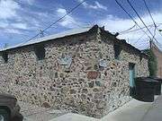
Fieldstone structures

The Pvt. Matthew B. Juan monument in the town of Sacaton, Arizona.
Michael Sullivan was a local stonemason who in the 1920s built various structures of fieldstone in Casa Grande. The stones collected from the surface of fields where it occurs naturally. The stones used as fieldstones are building construction materials which are collected from the surface of fields where they occur naturally. Sullivan’s last completed project was the Pvt. Matthew B. Juan monument in the town of Sacaton, Arizona. Sullivan did not see the dedication of this monument as he died on February 25, 1928 of a heart attack while en route to Sacaton for a visit. Among the structures which he built are the following:[7][8]
- The House at 222 9th St., built in 1920 and located at the same address.
- The House at 320 West Eighth Street a.k.a. The Stone Barber Shop , was built in 1920 and is located at 320 W. 8th St.
- The Stone Bungalow was built in 1921 and is located at 515 E. 3rd St.
- The Stone Warehouse was built in 1922 and is located in the rear of the building at 119 Florence St.
- The Casa Grande Woman's Club Building , built in 1924 and located at 407 N. Sacaton St.
- The Casa Grande Stone Church, built in 1927 and located at 110 W. Florence Boulevard.
- The Fisher Memorial Home, built in 1927 and located at 300 E. 8th St.
- The Vasquez House, was built in 1927 and located at 114 E. Florence Boulevard.
Buildings and Houses of religious worship
Historic buildings and houses of religious worship in Casa Grande
(National Register of Historic Places [4]) |
|---|
| The Cruz Trading Post was built in 1888 and is located at 200 W. Main St. It was listed in the National Register of Historic Places in 1985, reference #85000883. |
| The Casa Grande Hotel was built in 1898 and is located at 201 W. Main Ave. (behind the Southern Pacific Railroad Depot) It was listed in the National Register of Historic Places in 1985, reference #85000881. |
| The Johnson's Grocery Store was built in 1907 and is located at 301 N. Picacho St. It was listed in the National Register of Historic Places in 1985, reference #85000885. |
| The Ward's Variety Store was built in 1914 and is located at 112 N. Sacaton St. It was listed in the National Register of Historic Places in 1985, reference #85000898. |
| The Central Creditors Association Building was built in 1914 and is located at 118 N. Sacaton St. It was listed in the National Register of Historic Places in 1985, reference #85000882 . |
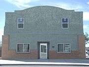
| The Casa Grande Union High School was built in 1920 and is located at 510 E. Florence Boulevard. The building now serves as the Casa Grande City Hall. The structure was listed in the National Register of Historic Places in 1986, reference #86000821. |
| The Casa Grande Garage was built in 1922 and is located at 117 N. Sacaton St. it is listed in the Casa Grande Historic Register. |
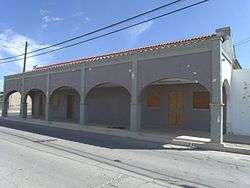
| The Pioneer Market was built in 1922 and is located at 119 N. Florence St. It was listed in the National Register of Historic Places in 1985, reference #85000919. |
| The Stone Warehouse was built in 1922 and is located in the rear of the building at 119 Florence St. It was listed in the National Register of Historic Places in 1985, reference #85000896. |
| The Building at 121 North Florence Street was built in 1923 and is located at 121 N. Florence St. It was listed in the National Register of Historic Places in 2002, reference #02000737. |
| The Casa Grande Woman's Club Building was built in 1924 and is located at 407 N. Sacaton St. It was listed in the National Register of Historic Places in 1979, reference #79000425. |
| The Southern Pacific Railroad Depot was built in 1925 and is located at 201 W. Main St. The Casa Grande Hotel Building, built in 1898, is located behind the depot The depot was listed in the National Register of Historic Places in 2002, reference #02000734. |
| The Casa Grande Stone Church (now known as Heritage Hall) was built in 1927 and is located at 110 W. Florence Boulevard. It was listed in the National Register of Historic Places in 1978, reference #78000567. |
| The Fisher Memorial Home (a house/funeral home combination) was built in 1927 and is located at 300 E. 8th St. The building was built in 1927. It was listed in the National Register of Historic Places in 1985, reference #85000884. |
| The Casa Grande Hospital was built in 1928 and is located at 601 N. Cameron Ave. It was listed in the National Register of Historic Places in 2002, reference #02000740. |
| The Prettyman's Meat Market and Grocery/Brigg's Jeweler structure was built in 1929 and is located at 110 W. Main Ave. It was listed in the National Register of Historic Places in 1985, reference # 85000891. |
| The Paramount Theatre was built in 1929 and is located at 420 N. Florence St. It was listed in the National Register of Historic Places in 1999, reference #990001067. |
| The Casa Grande Dispatch Building was built in 1929 and is located at 109 E. 2nd St. It was listed in the National Register of Historic Places in 2002, reference #02000747. |
| The Southside Elementary School was built in 1930 and is located at 501 S. Florence St. It is listed in the Casa Grande Historic Register. |
| The Rebecca Dalis School House was built in 1934 and is located at 110 W. Florence Blvd. It is listed in the Casa Grande Historic Register. |
| Saint Anthony's Church was built in 1935 and is located at 215 N. Picacho St. It was listed in the National Register of Historic Places in 1985, reference #85000892. |
| Saint Anthony's Church Rectory was built in 1935 and is located at 201 N. Picacho St. It was listed in the National Register of Historic Places in 1985, reference #85000892. |
| The Mandell and Meyer Building was built in 1937 and is located at 211 N. Florence St. It was listed in the National Register of Historic Places in 2002, reference #02000736. |
| The First Baptist Church was built in 1938 and is located at 218 E. 8th St. It was listed in the National Register of Historic Places in 2002, reference #02000751. |
| The Lincoln Hospital was built in 1940 and is located at 112 N. Brown Ave. It was listed in the National Register of Historic Places in 2002, reference #02000741. |
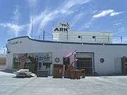
| The S.S. Blinky Jr. Building was built in 1946 and is located at 465 W. Gila Bend Highway. It was listed in the National Register of Historic Places in 2002, reference #02000748. |
| The V.W. Kilcrease Building was built in 1948 and is located at 139 W. 1st St. It was listed in the National Register of Historic Places on November 20, 2002, reference #02000754. |
| The William Cox Building was built in 1948 and is located at 501 N. Marshall St. It was listed in the National Register of Historic Places in 1999, reference #99001068. |
| The Church of the Nazarene was built in 1949 and is located at 305 E. 4th St.. It was listed in the National Register of Historic Places in 2002, reference #02000750. |
| The Valley National Bank building was built in 1950 and is located at 221 N. Florence St. It was listed in the National Register of Historic Places in 2002, reference #02000733. |
| The Building at 400 East Third Street (once the Church of Christ) was built in 1950 and is located at 400 E. 3rd St. It was listed in the National Register of Historic Places in 2002, reference #02000749. |
|
Houses, etc.
Historic houses and fire truck in Casa Grande
(National Register of Historic Places [4]) |
|---|
| The Bien/McNatt House was built in 1880 and is located at 208 W. 1st St. It was listed in the National Register of Historic Places in 1985, reference #85000880. |
| The Judge William T. Day House was built in 1886 and is located at 306 W. 1st St. It was listed in the National Register of Historic Places in 1985, reference #85001624. |
| The Shonessy House was built in 1900 and is located at 115 W. Main Ave. It was listed in the National Register of Historic Places in 1985, reference #85000894. |
| The Meehan/Gaar House was built in 1903 and is located at 200 W. 1st St. Fanne Gaar bought the house in 1920. She became mayor of Casa Grande in 1927, a first for a woman in Arizona. Gaar lived in the house until her death in 1971. It was listed in the National Register of Historic Places in 1985, reference #85000890. [9] |
| The BeDillions House built in 1917 and located at 800 Park Ave. It is listed in the Casa Grande Historic Register. |
| The House at 323 West Eighth St. was built in 1918 and is located at 323 W. 8th St. It was listed in the National Register of Historic Places in 2002, reference #02000744. |
| The House at 736 North Center Avenue was built in 1919 and is located at 736 N. Center Ave. It was listed in the National Register of Historic Places in 2002, reference #02000738. |
| The House at 320 West Eighth Street a.k.a. The Stone Barber Shop was built in 1920 and is located at 320 W. 8th St. It was listed in the National Register of Historic Places in 2002, reference #02000745. |
| The Wilbur O. Bayless/Grasty House which was built in 1920 and is located at 221 N. Cameron St. It was listed in the National Register of Historic Places in 1985, reference #85000879. |
| The Gus Kratzka House (now the Casa Grande Art Museum) was built in 1929 and is located at 319 W. 3rd Street. It was listed in the National Register of Historic Places in 1985, reference #85000886. |
| The Henry and Anna Kochsmeier House was built in 1929 and is located at 403 W. 2nd Ave. It was listed in the National Register of Historic Places in 2002, reference #02000746. |
| The Stone Bungalow was built in 1921 and is located at 515 E. 3rd St. It was listed in the National Register of Historic Places in 1985, reference #85000995. |
| The Earl Bayless House which was built in 1922 and is located at 211 N. Cameron St. It was listed in the National Register of Historic Places in 1985, reference #85000878. |
| Extension of the Earl Bayless House which was used as a store and which is located at 211 N. Cameron St. It was listed in the National Register of Historic Places in 1985, reference #85000878. |
| The House at North Lehmberg Avenue a.k.a. Spanish Eclectic House was built in 1925 and is located at 1105 N. Lehmberg Ave. It was listed in the National Register of Historic Places in 2002, reference #02000735. |
| The Period Revival House was built in 1927 and is located at 905 N. Lehmberg St. It was listed in the National Register of Historic Places in 1985, reference #850001623. |
| The Vasquez House was built in 1927 and is located at 114 E. Florence Boulevard. It was listed in the National Register of Historic Places in 1985, reference #85000897. |
| The House at 59 North Brown Avenue a.k.a. Fieldstone House was built in 1928 and is located at 59 N. Brown Ave. It was listed in the National Register of Historic Places in 2002, reference #02000742. |
| The Benjamin Templeton House was built in 1929 and is located at 923 N. Center Ave. It was listed in the National Register of Historic Places in November 20, 2002, reference #02000739 |
| The House at 317 East Eighth Street was built in 1929 and is located at 317 E. 8th St. It was listed in the National Register of Historic Places in 2002, reference #02000753. |
| The House at 222 West Ninth St. was built in 1920 and is located at 222 W. 9th St. It was listed in the National Register of Historic Places in 2002, reference #0200073. |
| The Dr. H. B. Lehmberg House was built in 1929 and is located at 929 N. Lehmberg St. It was listed in the National Register of Historic Places in 1985, reference #85000888. |
| The White House was built in 1929 and is located at 901 N. Morrison. The house was listed in the National Register of Historic Places in 1985, reference #85000899. |
| The C. J. (Blinky) Wilson House was built in 1929 and is located at 223 W. 10th St. It was listed in the National Register of Historic Places in 1985, reference #85000900. |
| The Walter Wilbur House was built in 1939 and is located at 904 E. 8th St. It was listed in the National Register of Historic Places in 2002, reference #02000752. |
| Historic Casa Grande Fire Department Engine #1 a 1928 American LaFrance fire truck on display in the Casa Grande Historical Society Museum at 110 W Florence Blvd. |
|
Corona Satellite Calibration Targets
The Corona Satellite Calibration Targets refer to two hundred and seventy two [10][11] concrete markers, built in the 1960s in the desolate Arizona desert, in and around Casa Grande, Arizona that helped to calibrate satellites of the Corona spy satellite program. They are large concrete crosses in the ground with a resemblance of a large Maltese Cross. The targets are only visible if one walked up to them or passed over them from a great height, like space.
Each of the targets has a manhole with a cement cover and rebar handles. The manhole is located on the west arm of the cross. According to Gary Morgan, member of the Cold War Museum in Warrenton VA., the 6 pieces of rebar, which protrude at an equal distance from each other, may have been used to hold laser lighting to give a more accurate fix on each target.[11]
The targets were abandoned following the end of the program in 1972. Most of the targets were either destroyed or demolished. Pictured are two of the remaining targets which have survived. The first one pictured (Y47) is located on the southeast corner of South Montgomery and West Cornman Roads and the second (Y4-) one on the northeast corner of West Cornman Road and Carmel Blvd.[12]
| Two Corona Satellite Calibration Targets in Casa Grande, Arizona. |
|---|
| The first Corona Satellite Calibration Target (Y4-7) is located on the southeast corner of South Montgomery Road and West Cornman Road. |
| Manhole, with cement cover and rebar handles of the first Corona Satellite Calibration Target. |
| A close-up view of the first Corona Satellite Calibration Target manhole cover. Around the cover protrudes 6 equal distant pieces of rebar. |
| The first Corona Satellite Calibration Target U.S. Corps of Engineers 1967 survey mark. |
| Close-up view of the first Corona Satellite Calibration Target U.S. Corps of Engineers 1967 survey mark. |
| The second Corona Satellite Calibration Target (Y4-) is located on the northeast corner of West Corman Road and Carmel Blvd. |
| The second Corona Satellite Calibration Target manhole cover. |
| Close-up view of the second Corona Satellite Calibration Target manhole cover. |
| The survey mark of the U.S. Corps of Engineers was once located here. |
|
Further reading
- "Casa Grande (AZ) (Images of America)"; by Dawn Snell and the Casa Grande Valley Historical Society; Publisher: Arcadia Publishing (November 28, 2011); ISBN 978-0738579535.
See also
Other cities and towns in Arizona with articles of their historic properties
- List of historic properties in Bisbee, Arizona
- List of historic properties in Chandler, Arizona
- List of historic properties in Flagstaff, Arizona
- List of historic properties in Florence, Arizona
- List of historic properties in Glendale, Arizona
- List of historic properties in Goldfield, Arizona
- List of historic properties in Mesa, Arizona
- List of historic properties in Paradise Valley, Arizona
- List of historic properties in Peoria, Arizona
- List of historic properties in Phoenix, Arizona
- List of historic properties in Scottsdale, Arizona
- List of historic properties in Tempe, Arizona
- List of historic properties in Tombstone, Arizona
- List of historic properties in Wickenburg, Arizona
- List of historic properties in Winslow, Arizona
References


-1929.JPG)


_Wilson_House-1929-2.JPG)


