List of former places of worship in Wealden

In Wealden, the largest of six local government districts in the English county of East Sussex, there are 41 former churches, chapels and places of worship which are now used for other purposes or are disused. The mostly rural district, with five small towns and dozens of villages, has a 1,200-year documented history of Christian worship—a Saxon leader founded a church at Rotherfield in 790—and by the 19th century nearly every settlement had at least one church, as formerly extensive parishes were split up. Some have since fallen out of use because of changing patterns of population or declining attendance, or because they have been superseded by other churches. Protestant Nonconformism, always strong in Sussex, flourished in the area now covered by the district: many Baptist, Methodist and Congregational chapels were built, and although most survive, not all remain in religious use. The district also has more than 130 current places of worship.
English Heritage has awarded listed status to more than 60 current and former church buildings in Wealden. A building is defined as "listed" when it is placed on a statutory register of buildings of "special architectural or historic interest" in accordance with the Planning (Listed Buildings and Conservation Areas) Act 1990.[1] The Department for Culture, Media and Sport, a Government department, is responsible for this; English Heritage, a non-departmental public body, acts as an agency of the department to administer the process and advise the department on relevant issues.[2] There are three grades of listing status. Grade I, the highest, is defined as being of "exceptional interest"; Grade II* is used for "particularly important buildings of more than special interest"; and Grade II, the lowest, is used for buildings of "special interest".[3] As of February 2001, there were 47 Grade I-listed buildings, 106 with Grade II* status and 2,020 Grade II-listed buildings in Wealden.[4]
Wealden and its places of worship

Covering an area of 83,317 hectares (205,880 acres; 321.69 sq mi),[5] Wealden is the largest of the six local authority areas in East Sussex,[6] which has three small, highly urbanised coastal areas (the city of Brighton and Hove[note 1] and the boroughs of Eastbourne and Hastings) and a large rural hinterland covered by three districts. Wealden is at the centre of these: the district of Lewes lies to the west and Rother is to the east.[7][8]
Wealden's population at the time of the United Kingdom Census 2001 was 140,023.[5] Five small towns—Crowborough, Hailsham, Heathfield, Polegate and Uckfield—account for about half of these people,[6] and each has several places of worship catering for different denominations. The rest of the population is spread across dozens of villages and hamlets in the largely rural district.[6] Many of these settlements have at least one church—often an ancient building on a site where worship has taken place for over a thousand years. St Wilfrid, exiled to Sussex in the late 7th century, and his near-contemporary St Cuthman rapidly Christianised the county, and the 111 churches described in the Domesday Book of 1086 was a significant underestimate.[9]
Closed or disused places of worship
| Name | Image | Location | Denomination/ Affiliation |
Grade | Notes | Refs |
|---|---|---|---|---|---|---|
| Alfriston United Reformed Church | .JPG) |
Alfriston 50°48′27″N 0°09′26″E / 50.8074°N 0.1572°E |
United Reformed Church | II | On the village green by the River Cuckmere, this former Congregational chapel was built in 1801. The windows on the rendered façade are flat-arched and round-headed on the ground and first floors respectively. Independent and Countess of Huntingdon's Connexion congregations have also used the building. A partnership was formed with St Andrew's Church and it closed on 31 May 2009. | [10][11] [12][13] [14][15] |
| Blackboys Methodist Church | _(2).JPG) |
Blackboys 50°58′01″N 0°10′21″E / 50.9670°N 0.1725°E |
Methodist | – | The owner of nearby Possingworth Manor gave some of his land for this chapel, originally built for the Free Church community. The brick-built Vernacular-style building opened in 1883; planning permission to convert it into a house was granted in 2006, and its registration for marriages was cancelled in the same year. | [16][17] [18] |
| Boars Head Chapel |  |
Boarshead, Crowborough 51°04′17″N 0°11′17″E / 51.0714°N 0.1880°E |
Methodist | – | A small chapel was built in the 19th century for the Wesleyan Methodist community at Boarshead. It was served from the Wesleyan church at Crowborough, which was the first of many Nonconformist places of worship in the town. Boars Head Chapel was deregistered for worship in 1967 and is now the Chapel House Studio. | [19][20] [21] |
| Colkins Mill Free Church |  |
Coggins Mill, Mayfield 51°01′34″N 0°16′29″E / 51.0262°N 0.2748°E |
Free Church | – | Coggins (or Colkins) Mill, a tiny hamlet east of Mayfield, acquired a place of worship in the 1870s when a resident donated land for a wooden chapel served by itinerant Nonconformist preachers. In 1984, the congregation bought the former Methodist and Congregational chapel in Mayfield village centre, and the old chapel became a house. | [22] |
| Cousley Wood National School |  |
Cousley Wood 51°04′35″N 0°21′28″E / 51.0764°N 0.3578°E |
Anglican | – | Built in 1864 as a National School, this was in educational use until 1949 but also served as a church for many years. It was officially licensed in 1938 by the Bishop of Chichester, but congregations fell and the church became unviable. It closed in 1970 and was converted for residential use. | [23] |
| Cousley Wood Free Church |  |
Cousley Wood 51°04′33″N 0°21′01″E / 51.0759°N 0.3504°E |
Non-denominational | – | Founded as the Monks Lane Mission in 1902, this chapel changed its name in 1973 and offered interdenominational services. The "tin tabernacle" had blue corrugated iron walls and some brickwork, but has been altered since its sale and conversion into a house. | [24][25] [26] |
| Cowbeech Preaching Station | Cowbeech 50°54′30″N 0°18′07″E / 50.9082°N 0.3020°E |
Baptist | II | A mid-18th century cottage had a Baptist chapel built on to it in 1834, for an Independent Baptist community founded near Herstmonceux in 1800. It fell out of use in about 1950, and the building is now one house. The timber-framed, weatherboarded chapel has a large sash window and a hipped roof. | [27][28] | |
| Branch Strict Baptist Chapel |  |
Crowborough 51°03′31″N 0°09′47″E / 51.0587°N 0.1631°E |
Baptist | – | Closed in 1988 or 1989 and converted into a shop, this was built in 1896 by the Congregational community. In 1906 it was taken on by members of the Forest Fold Baptist Chapel. Its red-brick Dutch gable survives. Its registration for worship was officially cancelled in February 2000. | [29][30] [31][32] [33][34] |
| Trinity Hall | %2C_Crowborough.JPG) |
Crowborough 51°03′34″N 0°09′58″E / 51.0594°N 0.1661°E |
Baptist | – | A group of Baptists who met in a house on Eridge Road in the 1950s raised money to build a church nearby. Going by the names Park Road Church and Trinity Hall, it opened in the early 1960s and had a full-immersion baptism tank. In 1994, permission was granted to convert the building into the headquarters of a Christian charity. | [35][36] [37] |
| Whitehill Citadel |  |
Crowborough 51°02′47″N 0°09′46″E / 51.0465°N 0.1627°E |
Salvation Army | – | Still in use in the 1980s, but now a well-used community centre and hall, Crowborough's Salvation Army place of worship was founded on 22 February 1908 by a Mrs Bassett. Its ministry covered a large area of East Sussex. Its registration for worship was officially cancelled in February 2000. | [34][35] [38] |
| Zion Chapel |  |
Danehill 51°01′55″N 0°00′03″W / 51.0319°N 0.0008°W |
Baptist | – | A Strict Baptist community was founded here in 1810, and member William Roberts founded this chapel in 1815. Gospel Standard Baptists took over in 1894, but closure came in about 1967. There is a wooden porch on the red-brick façade. | [29][39] [40] |
| Providence Chapel |  |
East Hoathly 50°55′31″N 0°09′56″E / 50.9253°N 0.1656°E |
Methodist | – | In 1849, a Vernacular-style chapel was built down a narrow lane in East Hoathly. It served Independent Baptist worshippers for its first 20 years, but in 1869 a Strict Baptist minister called T. Funnell took over and renamed it Providence Chapel. The photograph is of a house which stands on the site, the original building was demolished together with two cottages. Funnell founded the new Hope Chapel at Blackboys in 1877. | [41][42] |
| East Hoathly Methodist Chapel |  |
East Hoathly 50°55′32″N 0°09′55″E / 50.9256°N 0.1654°E |
Methodist | – | This chapel was in religious use until about 1941, although records exist of its marriage registration (granted in 1895) being cancelled in 1953. It was built in the centre of East Hoathly in 1900-1901; the architects were Hall, Cooper and Davis of London and Scarborough, the general building work being carried out by the local firms of Halls and Trills. The red-brick and stone building has a small spire, and a wide, six-light, stone-mullioned window is prominent on the façade. | [41][43] |
| Providence Strict Baptist Chapel |  |
Forest Row 51°05′18″N 0°01′48″E / 51.0884°N 0.0300°E |
Baptist | – | Forest Row's Strict Baptist community founded a chapel in 1874. They moved to a larger red-brick building on the same road in 1928, registered it for marriages in 1930 and continued worshipping there until the early 21st century. Planning permission for residential conversion was granted in 2009. | [28][44] [45][46] [47][48] |
| Our Lady of the Forest Church | %2C_Forest_Row.JPG) |
Forest Row 51°05′42″N 0°02′51″E / 51.0949°N 0.0475°E |
Roman Catholic | – | This church on the road to Hartfield was part of the parish of East Grinstead with Lingfield and Forest Row. The 1950s building was visited in 1963 by John F. Kennedy while he was staying with Prime Minister (and local resident) Harold Macmillan. A shortage of priests forced it to close from 25 December 2009. | [49][50] [51][52] |
| Framfield Congregational Chapel |  |
Framfield 50°57′51″N 0°07′53″E / 50.9643°N 0.1313°E |
Congregational | – | The congregation, inspired and led by a pastor from Uckfield's Congregational church, met first in a cottage then in a larger house in the 1890s. A chapel was constructed on a site nearby in 1896; it opened on 3 December that year. Framfield, Uckfield and Isfield chapels joined as one Fellowship in 1900. A marriage licence was granted in 1933, Framfield broke away from Uckfield in 1955, and the cause failed in about 1993. The chapel was later used as the Bethel Gospel Mission, but is now a house. The building shown is, apparently a house built in gothic style like a chapel and not the original Congregational Chapel which was a "tin hut" construction, since demolished. | [53][54] |
| Providence Chapel | _(2).JPG) |
Hadlow Down 50°59′45″N 0°10′54″E / 50.9958°N 0.1816°E |
Baptist | II | The declining congregation were forced to abandon their 138-year-old chapel when the Great Storm of 1987 wrecked it. The Classical-influenced red- and blue-brick three-bay chapel has since been restored as a house. The first building on the site, founded by Henry Smith in 1824, was Hadlow Down's first place of worship. | [28][55] [56][57] [58][59] [60] |
| Gate House Baptist Chapel | %2C_School_Road%2C_Hadlow_Down_(June_2015)_(1).JPG) |
Hadlow Down 51°00′05″N 0°10′29″E / 51.0013°N 0.1747°E |
Baptist | – | Henry Donkin moved here in 1885 and founded this mission room ("the Tin Heaven") on his land soon afterwards. The tin tabernacle was moved nearer the village centre in 1907 and was registered for marriages in 1918. It became a full-time chapel in 1922, but closed after incumbent pastor's death in 1940. The corrugated iron building became a canteen then commercial premises. | [61][62] |
| Halland Mission Hall |  |
Halland[note 2] 50°55′48″N 0°08′14″E / 50.9300°N 0.1373°E |
Anglican | – | Distance from the parish church at East Hoathly prompted the founding in 1886 of this mission room, which had a shingled spire and a belfry. The 114-capacity chapel also had a Sunday school, but this closed in 1941; the chapel itself held its last service in 1951, after which the building was modified and turned into a house. | [63][65] |
| Hartfield Methodist Chapel |  |
Hartfield 51°05′58″N 0°06′28″E / 51.0995°N 0.1078°E |
Methodist | – | This former chapel on the High Street has been in residential use since 1967, when it was deregistered for worship. It was built in 1865 to replace a 50-year-old wooden building used by early Wesleyan worshippers in the village. The Classical-style brick and stone building has arched windows and a pediment with mouldings. | [21][66] [67] |
| Kingdom Hall | .JPG) |
Hawkswood, Hailsham 50°52′40″N 0°15′31″E / 50.8777°N 0.2587°E |
Jehovah's Witnesses | – | Hailsham's first Kingdom Hall was registered for marriages in July 1975 but was superseded by a new building in Victoria Road from March 1996. Demolition was threatened in 2004, but it now houses the East Sussex Federation of Women's Institutes. | [68][69] [70][71] |
| St Catherine's Church | %2C_Heathfield.JPG) |
Heathfield 50°58′24″N 0°15′29″E / 50.9734°N 0.2580°E |
Roman Catholic | – | Until 2014, this was the parish church covering Heathfield and the Rother District villages of Burwash and Hurst Green. It dates from 1953 and is a gabled red-brick building with a timber-framed tiled roof. In 2014 the Church of Christ the King at Burwash became the parish church and this church was declared redundant. A planning application for its demolition and replacement with flats was submitted to Wealden District Council was submitted in November 2015. St Catherine's was also associated with an order of Benedictine sisters at Cross In Hand, whose chapel (dedicated to the Holy Cross) is now employed as a chapel of ease within the parish. | [72][73] [74][75] [76][77] |
| St Peter's Church | .jpg) |
Holtye Common 51°08′01″N 0°04′53″E / 51.1337°N 0.0813°E |
Anglican | – | William Moseley built a church at this rural location in 1836, but it was replaced in 1892 by prolific architect Lacy W. Ridge's small Perpendicular Gothic Revival building—just a nave and chancel with prominent flying buttresses and a belfry at the west end, all of stone. It was declared redundant as from 1 November 2007. | [78][79] [80] |
| Isfield Congregational Chapel |  |
Isfield 50°56′35″N 0°03′35″E / 50.9430°N 0.0597°E |
Congregational | – | The Isfield cause, linked with those in Framfield and Uckfield from 1900, started in about 1898 with help from Uckfield Congregational Church, which bought the chapel and adjoining houses in April 1943. Closure was approved on 31 March 1966, and the chapel was sold for residential conversion. | [81][82] |
| Bethel Strict Baptist Chapel |  |
Little London 50°57′21″N 0°14′04″E / 50.9558°N 0.2345°E |
Baptist | – | Now a dwelling called Chapel House, this tiny brick chapel on a lane in the parish of Waldron opened in 1879 and was closed exactly a century later. It was used by Independent Calvinists first, before becoming Strict Baptist. | [83][84] [85][86] |
| Wannock Baptist Chapel |  |
Lower Willingdon 50°48′26″N 0°14′40″E / 50.8071°N 0.2444°E |
Baptist | – | Founded in a cottage in 1838 or 1839 by Hailsham preacher Thomas Wall, this cause gained a permanent chapel in 1851 and became aligned to the Gospel Standard movement in 1880. The stuccoed Vernacular-style building had a porch, sash windows and ornate iron railings. It closed in 1972 and became a house. | [87][88] [89][90] |
| Ebenezer Strict Baptist Chapel |  |
Magham Down 50°52′49″N 0°17′06″E / 50.8804°N 0.2851°E |
Baptist | – | Also founded by Thomas Wall, this stuccoed wayside chapel dates from 1846. Its austere interior and tiny dimensions prompted Sussex church historian Robert Elleray to describe it as "possibly the smallest and simplest place of worship in Sussex". It closed in 1994 and was converted into a house. | [66][83] [84][90] |
| St John's Chapel |  |
Maynard's Green 50°57′03″N 0°14′57″E / 50.9508°N 0.2493°E |
Anglican | – | This rural hamlet near Heathfield was given a small chapel of ease in 1863. The Early English-style building had coursed stonework and red brickwork. It was converted into a house after its closure. | [91] |
| New Gospel Hall | 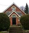 |
Maynard's Green 50°56′45″N 0°15′00″E / 50.9458°N 0.2500°E |
Open Brethren | – | Also now in residential use, this chapel was built of red brick in 1905 and was registered for marriages in May 1908. The cause was founded by Open Brethren from Edgmond Hall (now Edgmond Evangelical Church) in the Old Town area of Eastbourne, who travelled to villages throughout East Sussex in the 1880s to preach. A mission hall opened in 1887 and was succeeded by this building, which closed in February 1996 when Horam Chapel opened in nearby Horam. | [91][92] [93][94] |
| Nazarene Particular Baptist Chapel |  |
Ninfield 50°53′12″N 0°25′31″E / 50.8867°N 0.4253°E |
Baptist | – | Built for Independent Calvinistic Baptists in 1831 and renovated in 1878, this chapel later became Strict Baptist and was sometimes served by pastors from the Rehoboth Chapel at Pell Green. Religious use ceased in about 1971 and the chapel was deregistered in 1994. The cause originated in a house in nearby Russell's Green. | [83][95] [86][96] [97] |
| St Laurence's Chapel | Otteham Court, Polegate 50°49′45″N 0°15′10″E / 50.8292°N 0.2528°E |
Pre-Reformation[note 3] | II* | The remnants of this abbey chapel—sedilia, a piscina and two windows—are 14th-century, but worship has taken place at the site since 1175 or before. It was described as a parish church in the 15th and 16th centuries, until the Reformation. Otham Abbey was owned by Premonstratensian Canons who later moved to Bayham Abbey, and the stone-built chapel is now on private land. | [98][99] [100][101] [102] | |
| Rehoboth Chapel | 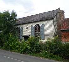 |
Pell Green, Wadhurst 51°04′26″N 0°20′50″E / 51.0738°N 0.3472°E |
Baptist | II | Strict Baptists met at Pell Green from 1818, and had their own place of worship from 1824 when Thomas Kemp built a chapel next to an old cottage. It was extended several times in its early history—for example, the three-bay façade was widened by the addition of one bay and a lean-to. The timber-framed, weatherboarded chapel was converted into a house in the 1980s. | [83][103] [85][104] [105][106] [107] |
| Mount House Chapel | Piltdown 50°58′48″N 0°03′30″E / 50.9801°N 0.0583°E |
Church of Christ then Baptist | – | A red- and blue-brick building in the Vernacular style served as a chapel for the Piltdown area near Uckfield from about 1860 until the late 20th century. It became a house in 1980. | [108][109] | |
| Rotherfield Methodist Church | |
Rotherfield 51°03′01″N 0°13′46″E / 51.0504°N 0.2295°E |
Methodist | – | Methodists met in a house from 1794, and other private buildings (including oast houses) were used until this red-brick chapel and attached classroom opened in 1879. It held 175 worshippers, but closed early in the 21st century. | [110][111] [112] |
| Little St Mary's Church | Rushlake Green 50°56′26″N 0°18′47″E / 50.9405°N 0.3130°E |
Anglican | – | Now a village hall and community centre, this short-lived place of worship served a small village in the parish of Warbleton, from whose parish church it may derive its name. The firm of J.D. Clarke and Sons submitted plans to the Incorporated Church Building Society to rebuild it in 1963–66. | [113][114] | |
| Russell's Green Wesleyan Methodist Chapel | 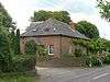 |
Russell's Green 50°52′34″N 0°25′00″E / 50.8761°N 0.4167°E |
Methodist | – | Wesleyan Methodists founded a hipped-roofed red-brick chapel at this hamlet south of Ninfield in 1832. It was extended later in that century to give an extra bay, and was registered for marriages in July 1921. The building is now residential, and the date-stone on the façade has been damaged. | [95][115] [116] |
| Shover's Green Baptist Chapel | .jpg) |
Shover's Green, Wadhurst 51°03′00″N 0°21′24″E / 51.0500°N 0.3566°E |
Baptist | II | Strict Baptists from Burwash expanded their mission in 1816 by founding a new chapel at this hamlet near Ticehurst. The three-bay, weatherboarded, arch-windowed building was completed in 1817. A lean-to vestry was added later, and the walls are now of brick. Closure came in about 1973, and the building became a house, retaining most of its features. | [85][89] [117][118] [119][120] [121] |
| Salvation Army Hall | 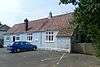 |
Sparrow's Green, Wadhurst 51°03′58″N 0°20′01″E / 51.0661°N 0.3336°E |
Salvation Army | – | The Wadhurst Corps of the Salvation Army was established in 1892, and it built a hall in the Sparrow's Green area of the village the following year (after initially meeting at founding member Samuel Fairbrother's house). The hall passed into commercial use after the dissolution of the Corps in 1975, and another hall (pictured) was used for a time. | [24][122] |
| Turner's Green Gospel Hall |  |
Turner's Green, Wadhurst 51°04′18″N 0°20′10″E / 51.0718°N 0.3360°E |
Open Brethren | – | The present building is the second on the site. The first corrugated iron chapel, dating from 1941 and registered for marriages in 1956, was destroyed by fire in 1970. A cedar wood and tile replacement meeting house, costing £2,500, was opened soon afterwards, but the cause failed in the early 1980s and the building was sold in 1987. | [24][106] [123][124] |
| Mount Hermon Baptist Chapel | 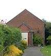 |
Turner's Green, Warbleton 50°57′06″N 0°19′29″E / 50.9518°N 0.3247°E |
Baptist | – | Thomas Dallaway seceded from Heathfield Chapel in 1865 and founded this new chapel, which became aligned to the Strict Baptist cause (and later the Gospel Standard movement). It was a Vernacular-style red-brick building with a porch. It was sold in the early 21st century and became a private wedding chapel; the congregation joined The Rest Chapel at nearby Three Cups Corner. Its marriage registration was cancelled in July 2007. | [89][125] [126][127] [128] [129] [130] |
| Uckfield Baptist Church |  |
Uckfield 50°58′37″N 0°06′00″E / 50.9770°N 0.1000°E |
Baptist | II | Seceders from Five Ash Down established a chapel in the north of Uckfield in 1788. The present building, now a house, dates from 1874 and was built of brick with arched windows. The entrance has distinctive bargeboards. In the 1920s, the congregation split and Strict Baptists moved to Foresters Chapel. Uckfield Baptist Church is still an active congregation, but it meets at a school: the former chapel's registration was cancelled in June 2005. | [89][131] [85][132] [133][134] [135] |
| Upper Dicker Methodist Chapel |  |
Upper Dicker 50°52′07″N 0°12′27″E / 50.8685°N 0.2075°E |
Methodist | – | This Wesleyan chapel had a short life: it was defunct shortly after appearing on a map of 1843, and later became a school, reading room, community hall, youth club and (in 1970) the headquarters of a cheese manufacturing and distribution company. | [136] |
| New Gospel Hall | Vines Cross, Horam 50°56′13″N 0°16′05″E / 50.9369°N 0.2681°E |
Plymouth Brethren | – | Opened in 1911, this chapel's initially large congregation ebbed away over the years; it was closed in the 1970s and sold for conversion into "an attractive and unusual" house. It stands on Ballsocks Lane. | [131][137] | |
| Wadhurst Town Chapel | 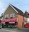 |
Wadhurst 51°03′43″N 0°20′25″E / 51.0620°N 0.3402°E |
Baptist | – | Only a circular window in the back wall gives any indication that this building (now a greengrocer's shop) was originally in religious use. It was built as a Wesleyan Methodist chapel and was acquired by Strict Baptists who had worshipped in a now demolished chapel of 1815. It was run from Shover's Green and fell out of use in 1935. | [24][89] [106][131] [138] |
See also
 Media related to Places of worship in Wealden at Wikimedia Commons
- List of current places of worship in Wealden
- List of demolished places of worship in East Sussex
Notes
- ↑ Brighton and Hove became a separate unitary authority in 1997, but is still part of the ceremonial county of East Sussex.
- ↑ Halland village was known as The Nursery until 1891, and it is under this name that plans for a mission church were lodged with the Incorporated Church Building Society in 1886–87.[63][64]
- ↑ The church fell out of use before the Reformation, when the Church of England was established.
References
- ↑ "Planning (Listed Buildings and Conservation Areas) Act 1990 (c. 9)". The UK Statute Law Database. Ministry of Justice. 24 May 1990. Retrieved 31 October 2010.
- ↑ "History of English Heritage". English Heritage. 2010. Retrieved 19 August 2011.
- ↑ "Listed Buildings". English Heritage. 2012. Archived from the original on 24 January 2013. Retrieved 24 January 2013.
- ↑ "Images of England — Statistics by County (East Sussex)". Images of England. English Heritage. 2007. Archived from the original on 27 December 2012. Retrieved 27 December 2012.
- 1 2 "Population Density (UV02)". 2001 UK Census statistics for Wealden. Office for National Statistics. 18 November 2004. Retrieved 29 October 2010.
- 1 2 3 "About Wealden". Wealden District Council. 18 February 2010. Retrieved 29 October 2010.
- ↑ "Wealden District Council location map" (PDF). Wealden District Council. 2006. Retrieved 29 October 2010.
- ↑ "Boundary map of East Sussex – districts" (PDF). East Sussex County Council. 2009. Retrieved 29 October 2010.
- ↑ Fisher 1970, p. 12.
- ↑ Nairn & Pevsner 1965, p. 396.
- ↑ Elleray 2004, p. 1.
- ↑ Stell 2002, p. 330.
- ↑ Historic England. "Details from listed building database (1043354)". National Heritage List for England. Retrieved 30 January 2012.
- ↑ "Book of Reports (General Assembly, Loughborough: 2010)". The United Reformed Church. 2010. p. 198. Retrieved 2 November 2011.
- ↑ Registered in accordance with the Places of Worship Registration Act 1855 (Number in Worship Register: 14567; Name: United Reformed Church; Address: High Street, Alfriston; Denomination: United Reformed Church). Retrieved 28 September 2012. (Archived version of list)
- ↑ Elleray 2004, p. 4.
- ↑ "Application Number: WD/2005/3482/F". Wealden District Council planning application WD/2005/3482/F. Wealden District Council. 10 February 2006. Retrieved 31 October 2010.
- ↑ The London Gazette: no. 58156. p. 15969. 20 November 2006. Retrieved 4 April 2012.
- ↑ s.n. 1993, pp. 50, 53.
- ↑ "Application Number: WD/1983/2806/F". Wealden District Council planning application WD/1983/2806/F. Wealden District Council. 8 December 1983. Retrieved 31 October 2010.
- 1 2 The London Gazette: no. 44309. p. 5309. 11 May 1967. Retrieved 5 July 2012.
- ↑ Howard (ed.) 1992, p. 24.
- ↑ Savidge & Mason 1988, p. 125.
- 1 2 3 4 "Wadhurst Churches and Chapels". The Wadhurst and Ticehurst Website (including Stonegate and Flimwell). Greenman Enterprise. 2010. Archived from the original on 6 March 2012. Retrieved 28 June 2014.
- ↑ Savidge & Mason 1988, p. 132.
- ↑ Registered in accordance with the Places of Worship Registration Act 1855 (Number in Worship Register: 33361; Name: Monks Lane Mission Hall; Address: Cousley Wood, Wadhurst; Denomination: Unsectarian). Retrieved 28 September 2012. (Archived version of list)
- ↑ Historic England. "Details from listed building database (1246865)". National Heritage List for England. Retrieved 30 January 2012.
- 1 2 3 Homan 1997, p. 278.
- 1 2 Homan 1997, p. 277.
- ↑ Elleray 2004, p. 18.
- ↑ s.n. 1933, p. 52.
- ↑ Payne 1985, p. 92.
- ↑ Chambers 1954, p. 101.
- 1 2 The London Gazette: no. 55775. p. 2226. 28 February 2000. Retrieved 29 May 2013.
- 1 2 Payne 1985, p. 93.
- ↑ "Application Number: WD/1994/0193/F". Wealden District Council planning application WD/1983/2806/F. Wealden District Council. 19 April 1994. Retrieved 1 November 2010.
- ↑ Registered in accordance with the Places of Worship Registration Act 1855 (Number in Worship Register: 69332; Name: Trinity Hall Evangelical Church; Address: Mill Crescent, off Park Road, Crowborough; Denomination: Christians not otherwise designated). Retrieved 28 September 2012. (Archived version of list)
- ↑ s.n. 1933, p. 53.
- ↑ Elleray 2004, p. 19.
- ↑ Chambers 1954, pp. 108–109.
- 1 2 Elleray 2004, p. 23.
- ↑ Chambers 1954, pp. 93–94.
- ↑ The London Gazette: no. 40034. p. 6606. 4 December 1953. Retrieved 24 October 2012.
- ↑ Elleray 2004, p. 25.
- ↑ "Application Number: WD/2009/0342/F". Wealden District Council planning application WD/2005/3482/F. Wealden District Council. 6 April 2009. Retrieved 1 November 2010.
- ↑ Chambers 1954, pp. 106–107.
- ↑ The London Gazette: no. 33651. p. 6187. 10 October 1930. Retrieved 5 July 2012.
- ↑ Registered in accordance with the Places of Worship Registration Act 1855 (Number in Worship Register: 52707; Name: Providence Strict Baptist Church; Address: Hoopyard, Forest Row; Denomination: Strict Baptists). Retrieved 28 September 2012. (Archived version of list)
- ↑ "Deaneries of the Diocese". Diocese of Arundel and Brighton website. DABNet. 2010. Retrieved 29 October 2010.
- ↑ "Our Lady of the Forest". Forest Row Community Website. 14 March 2007. Retrieved 30 October 2010.
- ↑ Registered in accordance with the Places of Worship Registration Act 1855 (Number in Worship Register: 67002; Name: Church of Our Lady of the Forest; Address: Hartfield Road, Forest Row; Denomination: Roman Catholics). Retrieved 28 September 2012. (Archived version of list)
- ↑ Beckford, Martin (21 December 2009). "Village church visited by JFK and Harold Macmillan to close on Christmas Day". Daily Telegraph. Telegraph Media Group. Retrieved 15 January 2013.
- ↑ Thorogood 1994, pp. 71–76.
- ↑ Registered in accordance with the Places of Worship Registration Act 1855 (Number in Worship Register: 70550; Name: Bethel Gospel Mission; Address: High Street, Framfield, Uckfield; Denomination: Christians not otherwise designated). Retrieved 28 September 2012. (Archived version of list)
- ↑ Elleray 2004, p. 26.
- ↑ Stell 2002, p. 341.
- ↑ Historic England. "Details from listed building database (1028312)". National Heritage List for England. Retrieved 30 January 2012.
- ↑ Hadlow Down Book Committee 1999, pp. 43–47.
- ↑ Chambers 1954, pp. 125–126.
- ↑ Registered in accordance with the Places of Worship Registration Act 1855 (Number in Worship Register: 1; Name: Providence Chapel; Address: Hadlow Down; Denomination: Calvinists). Retrieved 28 September 2012. (Archived version of list)
- ↑ Hadlow Down Book Committee 1999, pp. 47–48.
- ↑ The London Gazette: no. 31071. p. 14844. 17 December 1918. Retrieved 13 July 2012.
- 1 2 "List of Plans Available: Sussex (Records 461 to 470 of 518)". Church Plans Online project website. Lambeth Palace Library. 2012. Retrieved 12 October 2012.
- ↑ "The Villages". www.easthoathlyandhalland.co.uk. 7 October 2009. Retrieved 12 October 2012.
- ↑ Gould 2004, pp. 54–56.
- 1 2 Stell 2002, p. 342.
- ↑ Elleray 2004, p. 27.
- ↑ "Residents angry over flats plan". Eastbourne Herald. Johnston Publishing Ltd. 26 March 2004. Retrieved 24 October 2012.
- ↑ The London Gazette: no. 54369. p. 5282. 12 April 1996. Retrieved 24 October 2012.
- ↑ The London Gazette: no. 46652. p. 9982. 5 August 1975. Retrieved 24 October 2012.
- ↑ "Contact us". East Sussex Federation of Women's Institutes. 2012. Retrieved 24 October 2012.
- ↑ "Heathfield & Waldron Parish Council: Local Information". Heathfield and Waldron Parish Council. 2008. Archived from the original on 3 January 2013. Retrieved 1 March 2016.
- ↑ "Historical Information". Heathfield Town website. Heathfield Partnership Trust Company Ltd. 2014–2016. Archived from the original on 1 March 2016. Retrieved 1 March 2016.
- ↑ "Christ the King, Burwash". The Arundel and Brighton Diocesan Trust. 2016. Archived from the original on 1 March 2016. Retrieved 1 March 2016.
- ↑ "Heathfield, East Sussex". Diocese of Arundel and Brighton website. DABNet. 2013. Archived from the original on 10 June 2013. Retrieved 1 March 2016.
- ↑ Registered in accordance with the Places of Worship Registration Act 1855 (Number in Worship Register: 64525; Name: St Catherine's Church; Address: Mutton Hall Hill, Heathfield; Denomination: Roman Catholics). Retrieved 28 September 2012. (Archived version of list)
- ↑ "Planning Application Display: WD/2015/2276/F". Wealden District Council planning application WD/2015/2276/F. Wealden District Council. 11 November 2015. Archived from the original on 1 March 2016. Retrieved 1 March 2016.
The demolition of a redundant church and the construction of a new block of 8 no. flats.
- ↑ Elleray 2004, p. 32.
- ↑ Nairn & Pevsner 1965, p. 539.
- ↑ "The Church of England Statistics & Information: Lists (by diocese) of closed church buildings as at October 2012" (PDF). Church of England. 1 October 2012. Archived from the original on 30 January 2013. Retrieved 30 January 2013.
- ↑ Elleray 2004, p. 37.
- ↑ Thorogood 1994, pp. 73–76.
- 1 2 3 4 Homan 1997, p. 279.
- 1 2 Elleray 2004, p. 40.
- 1 2 3 4 Stell 2002, p. 356.
- 1 2 Chambers 1954, p. 128.
- ↑ Stell 2002, p. 358.
- ↑ Elleray 2004, p. 55.
- 1 2 3 4 5 Homan 1997, p. 280.
- 1 2 Chambers 1954, p. 80.
- 1 2 Elleray 2004, p. 41.
- ↑ The London Gazette: no. 28139. p. 3814. 22 May 1908. Retrieved 24 October 2012.
- ↑ Walkley 1972, p. 17.
- ↑ The London Gazette: no. 54346. p. 3957. 15 March 1996. Retrieved 14 January 2013.
- 1 2 Elleray 2004, p. 42.
- ↑ Stell 2002, p. 352.
- ↑ The London Gazette: no. 53798. p. 13437. 23 September 1994. Retrieved 26 April 2012.
- ↑ Longstaff-Tyrrell 2004, p. 122.
- ↑ Nairn & Pevsner 1965, p. 585.
- ↑ Whatmore 1978, p. 165.
- ↑ Historic England. "Details from listed building database (1182639)". National Heritage List for England. Retrieved 30 January 2012.
- ↑ Salzman 1901, pp. 173–190.
- ↑ Elleray 2004, p. 44.
- ↑ Nairn & Pevsner 1965, p. 610.
- ↑ Historic England. "Details from listed building database (1353663)". National Heritage List for England. Retrieved 30 January 2012.
- 1 2 3 Savidge & Mason 1988, p. 134.
- ↑ Chambers 1954, pp. 84–85.
- ↑ Elleray 2004, p. 45.
- ↑ "East Sussex Record Office: Baptist Churches". East Sussex Record Office catalogue. The National Archives. 2001–2009. Retrieved 31 October 2010.
- ↑ Elleray 2004, p. 47.
- ↑ Various Authors 1979, p. 73.
- ↑ Registered in accordance with the Places of Worship Registration Act 1855 (Number in Worship Register: 24784; Name: Methodist Church; Address: Town Row, Rotherfield; Denomination: Methodist Church). Retrieved 28 September 2012. (Archived version of list)
- ↑ "List of Plans Available: Sussex (Records 471 to 480 of 518)". Church Plans Online project website. Lambeth Palace Library. 2012. Retrieved 12 October 2012.
- ↑ Allen, John (11 June 2012). "Rushlake Green – Little St Mary". Sussex Parish Churches website. Sussex Parish Churches (www.sussexparishchurches.org). Retrieved 12 October 2012.
- ↑ Stell 2002, p. 353.
- ↑ The London Gazette: no. 32394. p. 5753. 19 July 1921. Retrieved 4 August 2013.
- ↑ Elleray 2004, p. 50.
- ↑ Nairn & Pevsner 1965, p. 613.
- ↑ Historic England. "Details from listed building database (1028045)". National Heritage List for England. Retrieved 30 January 2012.
- ↑ Savidge & Mason 1988, pp. 133–134.
- ↑ Chambers 1954, pp. 81–84.
- ↑ Savidge & Mason 1988, pp. 134–135.
- ↑ The London Gazette: no. 40795. p. 3241. 1 June 1956. Retrieved 26 April 2012.
- ↑ Registered in accordance with the Places of Worship Registration Act 1855 (Number in Worship Register: 65551; Name: Turners Green Gospel Hall; Address: Turners Green, Wadhurst; Denomination: Open Brethren). Retrieved 28 September 2012. (Archived version of list)
- ↑ "Churches and Chapels in Warbleton Parish". Warbleton Parish Council. 7 August 2009. Retrieved 30 October 2010.
- ↑ Elleray 2004, p. 54.
- ↑ "The Chantry Wedding Chapel Hire". The Chantry. 2010. Retrieved 31 October 2010.
- ↑ "Local venues and resources for events and activities". Rushlake Green Community Website and Newsletter. 2010. Retrieved 31 October 2010.
- ↑ Chambers 1954, p. 67.
- ↑ The London Gazette: no. 58401. p. 10644. 24 July 2007. Retrieved 29 May 2013.
- 1 2 3 Elleray 2004, p. 53.
- ↑ "Places of Worship". Uckfield Official Guide. Local Authority Publishing. 2010. Retrieved 31 October 2010.
- ↑ Historic England. "Details from listed building database (1194400)". National Heritage List for England. Retrieved 30 January 2012.
- ↑ Chambers 1954, pp. 94–95.
- ↑ The London Gazette: no. 57681. p. 8114. 22 June 2005. Retrieved 29 May 2013.
- ↑ Smith 2003, p. 35.
- ↑ Gillet & Russell 1991, p. 69.
- ↑ Chambers 1954, p. 85.
Bibliography
- Chambers, Ralph F. (1954). The Strict Baptist Chapels of England – Volume II: Sussex. Thornton Heath: Ralph F. Chambers.
- Elleray, D. Robert (2004). Sussex Places of Worship. Worthing: Optimus Books. ISBN 0-9533132-7-1.
- Fisher, E.A. (1970). The Saxon Churches of Sussex. Newton Abbot: David & Charles. ISBN 0-7153-4946-5.
- Gillet, Alan; Russell, Barry K. (1991). Around Heathfield in Old Photographs: a Second Selection. Stroud: Alan Sutton Publishing Ltd. ISBN 0-86299-950-2.
- Gould, Wyndham (Autumn 2004). Harker, Michael, ed. "Halland Mission Hall". Hindsight. Uckfield: Uckfield and District Preservation Society. 10. ISSN 1464-6293.
- Hadlow Down Book Committee (1999). Hadlow Down: an Autobiography (Incorporating Alice Catharine Day's Glimpses of Rural Life in Sussex). Hadlow Down: Hadlow Down Millennium Book Committee. ISBN 0-9537125-0-8.
- Homan, Roger (1997). "Mission and Fission: the organization of Huntingtonian and Calvinistic Baptist causes in Sussex in the 18th and 19th centuries". Sussex Archaeological Collections. Lewes: Sussex Archaeological Society. 135. ISSN 0143-8204.
- Howard, Eve (ed.) (1992). Mayfield: a Short Historic Guide (Illustrated) (3rd ed.). Mayfield: Mayfield Local History Society.
- Longstaff-Tyrrell, Peter (2004). A Portrait of Polegate (1st ed.). Polegate: GoteHouse Publishing. ISBN 0-9521297-9-5.
- Nairn, Ian; Pevsner, Nikolaus (1965). The Buildings of England: Sussex. Harmondsworth: Penguin Books. ISBN 0-14-071028-0.
- Payne, Malcolm (1985). Crowborough: the Growth of a Wealden Town. Studley: K.A.F. Brewin Books. ISBN 0-947731-04-0.
- Savidge, Alan; Mason, Oliver (1988). Wadhurst: Town of the High Weald. Rainham: Meresborough Books. ISBN 0-948193-35-2.
- Stell, Christopher (2002). Nonconformist Chapels and Meeting-houses in Eastern England. Swindon: English Heritage. ISBN 1-873592-50-7.
- Thorogood, Derek (1994). Uckfield Congregational Church: An Account of the Years 1866–1972. Framfield: Derek Thorogood. ISBN 0-9524531-0-X.
- Various authors (1979). Our Village: a Pictorial Record of a Sussex Village. Rotherfield: Rotherfield History Research Group.
- Walkley, Victor G. (1972). A Church Set on a Hill: the Story of Edgmond Hall, Eastbourne, 1872–1972. Eastbourne: Upperton Press.
- Whatmore, Leonard E. (1978). Story of Our Lady of Ransom, Eastbourne.
- s.n. (1933). The Story of Crowborough. Tunbridge Wells: Courier Co. Ltd.
Places of worship in Sussex (by district) | ||
|---|---|---|
| East Sussex | .jpg) | |
| West Sussex | ||
| Demolished | ||
| Cathedrals | ||