List of crossings of the Red Deer River
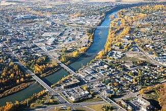
Bridges over the river in the city of Red Deer
This is a list of crossings of the Red Deer River in the Canadian province of Alberta from the river's origin in Sawback Range in Alberta to its mouth at the South Saskatchewan River in Saskatchewan. Even though the river flows through the province of Saskatchewan, there are no current crossings over the river in the province.
Crossings in use
This is a list of crossings in use from upstream to downstream. Crossings include bridges, ferries, and dams (road, pedestrian, and railway).


Alberta
Saskatchewan
There are currently no crossings in Saskatchewan.
Crossings no longer in use

The Mintlaw Viaduct
This is a list of notable crossings that are no longer in use that are not already listed above. Although there are quite a few crossings of the Red Deer River that are no longer in use, there are only a few worth mentioning.
| Crossing | Carried | Location | Notes | Coordinates |
|---|---|---|---|---|
| Mintlaw Viaduct[40] | Alberta Central & Canadian Pacific Railway | south of Mintlaw | Closed in 1983. | 52°12′28″N 113°54′51″W / 52.20778°N 113.91417°W |
| Railway bridge[10] | Canadian National Railway - Canadian Northern Western Railway | Red Deer near Waskasoo Creek | Closed in 1941. Collapsed. | 52°16′42″N 113°48′17″W / 52.27833°N 113.80472°W |
| Midland Railway Bridge[41] | Canadian National Railway - Goose Lake Line | northwestern Drumheller | Closed in 2010. Last train across in 2014.[42] | 51°27′52″N 112°45′29″W / 51.46444°N 112.75806°W |
| East Coulee Coal Railway Bridge[43] | Canadian Pacific Railway and some Canadian National Railway traffic | near East Coulee | Closed sometime in the 1970s or 1980s | 51°19′59″N 112°29′14″W / 51.33306°N 112.48722°W |
| Bullpound Railway Bridge[44] | Canadian Pacific Railway | near Bullpound | Closed sometime around 1980 | 51°4′44″N 111°59′14″W / 51.07889°N 111.98722°W |
Proposed Crossings
| Crossing | Carries | Location | Notes | Coordinates |
|---|---|---|---|---|
| Freeway bridge[45] | North Highway Connector (Alberta Highway 11A) | Red Deer near Wastewater Treatment Plant | Built in the next 2 to 5 years. | 52°18′36″N 113°47′17″W / 52.31000°N 113.78806°W |
References
- ↑ http://epod.usra.edu/blog/2005/04/earth-day-and-red-deer-bridge.htmll
- ↑ "Panoramio - Photo of Red Deer River Bridge". panoramio.com. Retrieved 16 August 2015.
- ↑ "Mountain Aire lodge". mountainairelodge.ca. Retrieved 16 August 2015.
- ↑ The Town of Sundre. "Town of Sundre > Red Deer River Bridge Flood Mitigation project update". sundre.com. Retrieved 16 August 2015.
- ↑ "Disclaimer for Hydrometric Information". ec.gc.ca. Retrieved 16 August 2015.
- ↑ Government of Alberta. "Public now has full access to Garrington Bridge". alberta.ca. Retrieved 16 August 2015.
- ↑ "Dickson Dam". ehcanadatravel.com. Retrieved 16 August 2015.
- ↑ "Red Deer River Innisfail to Waskasoo Creek - Canadian Canoe Routes". myccr.com. Retrieved 16 August 2015.
- ↑ "Historic-Fort-Normandeau". waskasoopark.ca. Retrieved 16 August 2015.
- 1 2 "Railway Bridges of Central Alberta - Forth Junction Project". forthjunction.com. Retrieved 16 August 2015.
- ↑ "3) floating under QE2 highway and railway bridges - Picture of Fort Normandeau, Red Deer". tripadvisor.ca. Retrieved 16 August 2015.
- ↑ http://www.reddeer.ca/media/reddeerca/city-government/plans-and-projects/greater-downtown-action-plan/Greater-Downtown-Action-Plan.pdf
- ↑ http://reddeer.ca/city-services/roads/construction-season/riverview-park-erosion-protection-project/
- ↑ "May 2014 News Archive". reddeer.ca. 29 April 2015. Retrieved 16 August 2015.
- ↑ "Canadian Pacific Railway bridge now 100 years old - Michael Dawe". forthjunction.com. Retrieved 16 August 2015.
- ↑ "June 2014 News Archive". reddeer.ca. 28 August 2014. Retrieved 16 August 2015.
- ↑ "Red Deer Greater Downtown Action Plan - Plan Overview". downtownreddeer.com. Retrieved 16 August 2015.
- ↑ "July 2014 News Archive". reddeer.ca. 23 July 2015. Retrieved 16 August 2015.
- ↑ http://www.reddeer.ca/whats-happening/news-room/news-archive/2015-news-archive/march-2015-news-archive/construction-at-river-bend-golf-and-recreation-area.html/
- ↑ "Joffre Bridge Fossil Exhibit". ualberta.ca. Retrieved 16 August 2015.
- ↑ "Grand Trunk Pacific in Central Alberta - CNR - Historical Perspective - Forth Junction". forthjunction.com. Retrieved 16 August 2015.
- ↑ "Content Bridge Campground". Lacombe Regional Tourism. Retrieved 16 August 2015.
- ↑ "Big Valley Bridge, on Highway 590, closed for routine maintenance". threehillscapital.com. Retrieved 16 August 2015.
- ↑ "Tolman east Badlands Campground". albertawow.com. Retrieved 16 August 2015.
- ↑ "Morrin Bridge Recreation Area". traveldrumheller.com. Retrieved 16 August 2015.
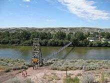
- ↑ "Bleriot Ferry". traveldrumheller.com. Retrieved 16 August 2015.
- ↑ Brendan Toft. "Gordon Taylor Bridge Delays". Drumhelleronline.com. Retrieved 16 August 2015.
- ↑ "Roper Road". geoview.info. Retrieved 16 August 2015.
- ↑ "Rosedale Suspension Bridge". traveldrumheller.com. Retrieved 16 August 2015.
- ↑ "Panoramio - Photo of Bridge over the Red Deer River". panoramio.com. Retrieved 16 August 2015.
- ↑ "Panoramio - Photo of Bridge Railings over Red Deer River@Drumheller". panoramio.com. Retrieved 16 August 2015.
- ↑ "Dorothy Ferry Bridge (Special Area No. 2, Alberta) - a photo on Flickriver". flickriver.com. Retrieved 16 August 2015.
- ↑ http://www.transportation.alberta.ca/Content/docType34/Production/finnegan_ferry.pdf/
- ↑ "Emerson Bridge Park". countyofnewell.ab.ca. Retrieved 16 August 2015.
- ↑ Government of Alberta. "Dinosaur - Volunteering". albertaparks.ca. Retrieved 16 August 2015.
- ↑ "Panoramio - Photo of Jenner Alberta Bridge". panoramio.com. Retrieved 16 August 2015.
- ↑ "Panoramio - Photo of Panoramic Red Deer River bridge October 2010". panoramio.com. Retrieved 16 August 2015.
- ↑ "View topic - AB Routes. South Saskatchewan and Milk basins. Post 2 of 3.". myccr.com. Retrieved 16 August 2015.
- ↑ "Village of Empress › On the border of Alberta and Saskatchewan". villageofempress.com. Retrieved 16 August 2015.
- ↑ "CPR/ACR Mintlaw steel trestle - Forth Junction". forthjunction.com. Retrieved 16 August 2015.
- ↑ "Bridge hunting – Drumheller Alberta". bigdoer.com. Retrieved 16 August 2015.
- ↑ "Abandonment Goose Lake Line". vanishingalberta.ca. Retrieved 16 August 2015.
- ↑ "East Coulee Truss Bridge". nationaltrustcanada.ca. Retrieved 16 August 2015.
- ↑ "Bridge hunting – Bullpound Alberta". bigdoer.com. Retrieved 16 August 2015.
- ↑ "North Highway Connector". parklandgeo.com. Retrieved 16 August 2015.
This article is issued from Wikipedia - version of the 10/29/2016. The text is available under the Creative Commons Attribution/Share Alike but additional terms may apply for the media files.