List of caves in Italy

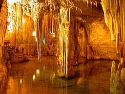
View of Castellana Caves

The following article shows a list of caves in Italy.

Overview

Main concentration of Italian caves (Italian : Grotte [1]) is close to the Alps and the Apennine Mountains, principally due to karst.

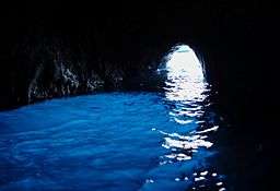
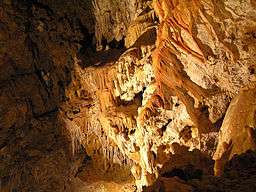
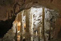
The main Italian touristic caves are Castellana and Frasassi. Other notable show caves are Pertosa, the Wind Cave, the Giant Cave, Castelcivita, Villanova, Toirano and Pastena.

Caves

The caves are listed by alphabetical order and there are shown the main touristic caves and other notable (ex.: archaeological or paleontological) underground voids.

Image Name Municipality Region Length Elevation Coordinates
Addaura Palermo (PA) Sicily 70 metres (230 ft) 38°11′13″N 13°21′02″E / 38.18694°N 13.35056°E / 38.18694; 13.35056
Arene candide Finale Ligure (SV) Liguria 90 amsl
Antro del Corchia Stazzema (LU) Tuscany ? 600 amsl 44°00′00″N 10°19′00″E / 44.00000°N 10.31667°E / 44.00000; 10.31667
Bigonda Grigno (TN) Trentino-Alto Adige/Südtirol ? 400 amsl 46°01′00″N 11°38′00″E / 46.01667°N 11.63333°E / 46.01667; 11.63333
Blue Grotto Anacapri (NA) Campania ? 0 amsl 40°33′38″N 14°12′17″E / 40.56056°N 14.20472°E / 40.56056; 14.20472
Borgio Verezzi Borgio Verezzi (SV) Liguria ? 200 amsl 44°9′35.26″N 8°18′19.16″E / 44.1597944°N 8.3053222°E / 44.1597944; 8.3053222
Bue Marino Dorgali [2] (NU) Sardinia ? 0 amsl 40°17′00″N 09°38′00″E / 40.28333°N 9.63333°E / 40.28333; 9.63333
Castelcivita Castelcivita (SA) Campania 3 km 94 amsl 40°28′00″N 15°13′00″E / 40.46667°N 15.21667°E / 40.46667; 15.21667
Castellana Castellana Grotte (BA) Apulia 3 km 290 amsl 40°52′32″N 17°08′59″E / 40.87556°N 17.14972°E / 40.87556; 17.14972
Cavallone Lama dei Peligni (CH)
Taranta Peligna (CH)
Abruzzo 1 km 1,300 amsl 42°01′00″N 14°10′00″E / 42.01667°N 14.16667°E / 42.01667; 14.16667
Ear of Dionysius Syracuse (SR) Sicily 0,06 km
(65 m)
400 amsl 37°04′00″N 15°16′00″E / 37.06667°N 15.26667°E / 37.06667; 15.26667
Frasassi Genga (AN) Marche 5 km 300 amsl 43°25′50″N 12°56′09″E / 43.43056°N 12.93583°E / 43.43056; 12.93583
Gelo Randazzo (CT) Sicily ? 2,043 amsl 37°48′22″N 14°58′00″E / 37.80611°N 14.96667°E / 37.80611; 14.96667
Giant Sgonico (TS) Friuli-V.G. 0,28 km
(280 m)
265 amsl 40°19′12″N 09°36′01″E / 40.32000°N 9.60028°E / 40.32000; 9.60028
Giusti Monsummano Terme (PT) Tuscany 0,20 km
(200 m)
570 amsl 43°52′00″N 10°49′57″E / 43.86667°N 10.83250°E / 43.86667; 10.83250
Ispinigoli Dorgali (NU) Sardinia ? 1,300 amsl 40°18′00″N 09°35′00″E / 40.30000°N 9.58333°E / 40.30000; 9.58333
Is Zuddas Santadi (CI) Sardinia ? 0 amsl 39°03′36″N 08°25′49″E / 39.06000°N 8.43028°E / 39.06000; 8.43028
Lauro Alcara li Fusi (ME) Sicily ? 1,068 amsl 38°01′00″N 14°42′00″E / 38.01667°N 14.70000°E / 38.01667; 14.70000
Maona Montecatini Terme (PT) Tuscany 0,20 km
(200 m)
255 amsl 43°54′02″N 10°46′37″E / 43.90056°N 10.77694°E / 43.90056; 10.77694
Neptune Alghero (SS) Sardinia ? 5 amsl 40°33′39″N 08°09′50″E / 40.56083°N 8.16389°E / 40.56083; 8.16389
Nereo Alghero (SS) Sardinia ? 0 amsl 40°33′39″N 08°09′50″E / 40.56083°N 8.16389°E / 40.56083; 8.16389
Paglicci Rignano Garganico (FG) Apulia ? 590 amsl 41°40′00″N 15°34′00″E / 41.66667°N 15.56667°E / 41.66667; 15.56667
Pastena Pastena (FR) Lazio ? 310 amsl 41°30′00″N 13°28′00″E / 41.50000°N 13.46667°E / 41.50000; 13.46667
Patone Arco (TN) Trentino-Alto Adige/Südtirol ? 300 amsl 45°55′00″N 10°52′00″E / 45.91667°N 10.86667°E / 45.91667; 10.86667
Pertosa Pertosa (SA) Campania 3 km 263 amsl 40°33′00″N 15°28′00″E / 40.55000°N 15.46667°E / 40.55000; 15.46667
San Giovanni Domusnovas (CI) Sardinia 2 km 150 amsl 39°20′13″N 08°37′40″E / 39.33694°N 8.62778°E / 39.33694; 8.62778
Smeraldo Conca dei Marini (SA) Campania ? 0 amsl 40°36′54″N 14°34′01″E / 40.6150°N 14.5670°E / 40.6150; 14.5670 (Grotta dello Smeraldo)
Su Mannau Fluminimaggiore (CI) Sardinia ? 256 amsl 39°26′00″N 08°30′00″E / 39.43333°N 8.50000°E / 39.43333; 8.50000
Su Marmuri Ulassai (OG) Sardinia ? 775 amsl 39°49′36″N 09°30′00″E / 39.82667°N 9.50000°E / 39.82667; 9.50000
Tiscali Oliena (NU)
Dorgali (NU)
Sardinia ? 500 amsl 40°14′30″N 09°29′30″E / 40.24167°N 9.49167°E / 40.24167; 9.49167
Toirano Toirano (SV) Liguria 2 km 50 amsl 44°07′00″N 08°13′00″E / 44.11667°N 8.21667°E / 44.11667; 8.21667
Trullo Putignano (BA) Apulia ? 375 amsl 40°51′25″N 17°06′36″E / 40.85694°N 17.11000°E / 40.85694; 17.11000
Villanova Lusevera [3] (UD)
Nimis (UD)
Friuli-V.G. 4 km 500 amsl 46°16′00″N 06°16′00″E / 46.26667°N 6.26667°E / 46.26667; 6.26667
Wind Vergemoli (LU) Tuscany 4,5 km 650 amsl 44°03′00″N 10°22′00″E / 44.05000°N 10.36667°E / 44.05000; 10.36667
Zelbio Zelbio (CO) Lombardy ? 900 amsl 45°54′00″N 09°11′00″E / 45.90000°N 9.18333°E / 45.90000; 9.18333

Notes and references

  1. Singular : Grotta
  2. The entrance is close to the hamlet of Cala Gonone
  3. The entrance is in the hamlet of Villanova delle Grotte

See also

Wikimedia Commons has media related to Caves of Italy.
This article is issued from Wikipedia - version of the 10/21/2016. The text is available under the Creative Commons Attribution/Share Alike but additional terms may apply for the media files.