List of airports in Azerbaijan
This is a list of airports in Azerbaijan, grouped by type and sorted by location.
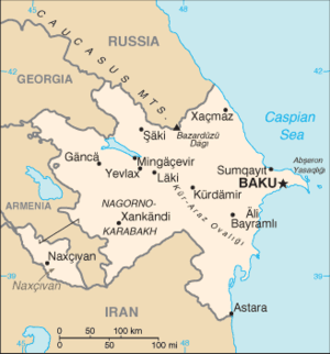
Azerbaijan, formally the Republic of Azerbaijan (Azerbaijani: Azərbaycan Respublikası), is a country in the Caucasus region of Eurasia. It is bounded by the Caspian Sea to the east, Russia to the north, Georgia to the northwest, Armenia to the west, and Iran to the south. The exclave of Nakhichevan is bounded by Armenia to the north and east, Iran to the south and west, while having a short borderline with Turkey to the northwest. The country's capital city is Baku. The majority-Armenian populated Nagorno-Karabakh region in the southwest of Azerbaijan occupied by Armenia in 1991, but it is not diplomatically recognized by any nation and is still considered a de jure part of Azerbaijan. Air transportation in Azerbaijan is regulated by the Ministry of Transportation of Azerbaijan Republic.
A$40 million project to lengthen the main runway at Ganja Airport has been completed, allowing the first international direct connections to the city. Similar projects are underway at Lenkoran and Zaqatala and due for completion in 2007.[1][2]
Airports
Names shown in bold indicate the airport has scheduled passenger service on commercial airlines.
See also
- Transport in Azerbaijan
- Azerbaijan Air Force
- List of airports by ICAO code: U#UB - Azerbaijan
- List of airports in Nagorno-Karabakh
- Wikipedia: WikiProject Aviation/Airline destination lists: Asia#Azerbaijan
References
- ↑ Airliner World, February 2007
- ↑ "Azerbaijan: Building Bridges for President Aliyev's Re-Election?". EurasiaNet. 30 May 2007.
Externakl links
- Survey of Russian Airfields, Edition 5 – 26 November 2005
- "ICAO Location Indicators by State" (PDF). International Civil Aviation Organization. 17 September 2010.
- "IATA Airline and Airport code Search". International Air Transport Association.
- "UN Location Codes: Azerbaijan". UN/LOCODE 2012-1. UNECE. 14 September 2012. – includes IATA codes
- "Airports in Azerbaijan". World Aero Data. – ICAO codes and coordinates
- "Airports in Azerbaijan". Great Circle Mapper. – IATA codes, ICAO codes and coordinates