List of Washington Metro stations

The Washington Metro (commonly called Metro, and unofficially Metrorail) is the rapid transit system of Washington, D.C., and neighboring communities in Maryland and Virginia, both inside and outside the Capital Beltway. It is the second busiest in the United States, behind the New York City Subway.[1]
The Washington Metro system was conceived as an alternative to the construction of a large freeway system throughout the Washington, D.C. area, and was partially financed with funds originally dedicated to highway construction.[2] Construction began in 1969, and in 1976 the first section of the Metro system opened along the Red Line between the Rhode Island Avenue and Farragut North stations in Washington, D.C. Throughout the 1970s and 1980s, more stations were opened in the city and the suburban communities of Arlington County, the City of Alexandria, and Fairfax County in Virginia as well as Montgomery and Prince George's Counties in Maryland. By 1991, five rail lines were open: the Red, Blue, Green, Orange, and Yellow Lines. The system as originally planned was completed in 2001 with the extension of the Green Line to Branch Avenue. In 2004, three stations were opened: an extension of the Blue Line to the Largo Town Center and Morgan Boulevard stations and the first infill station, NoMa–Gallaudet U.[3] In 2014, the Silver Line opened with five new stations: Greensboro, McLean, Spring Hill, Tysons Corner, and Wiehle – Reston East.[4]
As of 2015, there are 91 stations on the six lines in the Metro system. An infill station at Potomac Yard is planned to open in 2018 on the Yellow and Blue lines, and six more stations are planned in 2019 as part of the Phase II of the Silver Line.[5][6]
Ten Metrorail stations are officially designated transfer stations, although other intermediate stations also allow passengers to transfer between lines. Four of those stations have separate, perpendicular upper and lower levels which opened at different times. Two other transfer stations, Rosslyn and Pentagon, have parallel stacked platforms. Ten stations are termini, stations at the end of lines; several other non-terminus stations are used to short turn trains in regular service.[7]
As of June 2015, Union Station was the busiest station in the system, with an average of 31,186 passenger boardings per weekday. Nine of the top ten busiest stations are in the District of Columbia. Metro Center, a transfer point for the Blue, Orange, Silver, and Red Lines, is the busiest transfer station, with 27,058 boardings. Shady Grove in suburban Montgomery County, Maryland was the busiest terminus with 12,609 passenger boardings per weekday.[8]
Lines
There are six Washington Metro lines as of 2014. Each is named for a different color.[7] All lines except the Red Line share tracks, mostly through the downtown tunnels. As part of the Rush+ service introduced in June 2012, some Yellow Line trains run to Franconia-Springfield on tracks normally used for the Blue Line. Until the Silver Line opened, some rush hour Orange Line trains ran to Largo Town Center.
The Silver Line currently runs to Wiehle–Reston East via the Tysons Corner district as part of Phase I of its construction; Phase II will extend the Silver Line from Wiehle–Reston East to Ashburn via Dulles International Airport in 2018.
| Line | Ridership (May 2010)[9] | Stations[7] | Termini[7] | |
|---|---|---|---|---|
| |
277,741 (37%) | 27 | Shady Grove | Glenmont |
| |
187,663 (25%) | 26 | Vienna | New Carrollton |
| |
120,104 (16%) | 27 | Franconia-Springfield | Largo Town Center |
| |
105,091 (14%) | 21 | Branch Avenue | Greenbelt |
| |
59,781 (8%) | 17 | Huntington Franconia–Springfield (Rush+) |
Mount Vernon Square (rush peak) Fort Totten (all other times) Greenbelt (Rush+) |
| |
N/A | 28 (34 after Phase II) | Wiehle–Reston East Ashburn (2018) |
Largo Town Center |
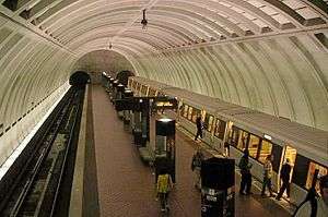
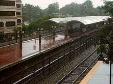
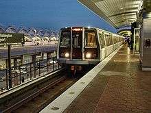
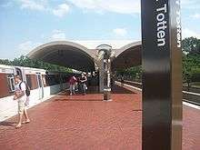
Stations


.jpg)
.jpg)


| * | Official transfer stations |
| |
Terminals |
| ** | Transfer station and terminal |
Future stations

Potomac Yard, planned to open in 2020, is to be an infill station between Braddock Road and National Airport on the Yellow and Blue lines.[5] Phase 2 of the Silver Line is tentatively planned to open in late 2019 with six new stations. When finished, the line's western terminus will be Ashburn.[6]
| Station | Lines | Jurisdiction | Projected Opening | Reference |
|---|---|---|---|---|
| Dulles International Airport |
Loudoun County, Virginia | 2019 | [6] | |
| Herndon | Fairfax County, Virginia | 2019 | [6] | |
| Innovation Center | Fairfax County, Virginia | 2019 | [6] | |
| Potomac Yard | Alexandria, Virginia | 2020 | [5] | |
| Reston Town Center | Fairfax County, Virginia | 2019 | [6] | |
| Loudoun Gateway | Loudoun County, Virginia | 2019 | [6] | |
| Ashburn | Loudoun County, Virginia | 2019 | [6] | |
Notes
- a The Yellow Line terminates at Mt Vernon Square during peak hours (5:00 am to 9:30 am and 3:00 pm to 7:00 pm Monday through Friday). Thus, the Columbia Heights, Fort Totten, Georgia Avenue–Petworth, Shaw–Howard University, and U Street stations are not served by the Yellow Line during these times.[10]
- b Stations noted in this list twice with upper and lower levels are considered by Metrorail to be a single station. The levels are noted separately here because they opened on different dates.
- c This station is served by additional trains during rush hour as part of the Rush Plus routing scheme. The secondary line listed does not serve the station during non-rush periods.
References
- ↑ "Transit Ridership Report: First Quarter 2015" (PDF). American Public Transportation Association. 27 May 2015. Retrieved 26 August 2015.
- ↑ Schrag, Zachary (2006). The Great Society Subway: A History of the Washington Metro. Johns Hopkins University Press. ISBN 0-8018-8246-X.
- ↑ "WMATA History" (PDF). Washington Metropolitan area Transit Authority. 2007. Retrieved 26 August 2015.
- 1 2 3 4 5 "Metro Facts" (PDF). Washington Metropolitan area Transit Authority. 2014. Retrieved 26 August 2015.
- 1 2 3 Lazo, Luz (22 December 2015). "Metro adds the proposed Potomac Yard station to its rail system". Washington Post. Retrieved 22 December 2015.
- 1 2 3 4 5 6 7 8 "Airports Authority Updates Status of Silver Line Metrorail Construction Project" (Press release). Metropolitan Washington Airports Authority. 27 April 2015. Retrieved 26 August 2015.
- 1 2 3 4 5 6 "Stations". Metrorail Website. Washington Metropolitan Area Transit Authority. Retrieved August 4, 2014.
- 1 2 "Metrorail Average Weekday Passenger Boardings" (PDF). Washington Metropolitan Area Transit Authority. June 2015. Retrieved August 19, 2015.
- 1 2 3 4 "Metro Media Guide" (PDF). Washington Metropolitan Area Transit Authority. 2010. Retrieved July 14, 2011.
- ↑ Weiss, Eric M (December 30, 2006). "Yellow Line Is En Route to Fort Totten". The Washington Post. p. B01.
| Subsidiaries | |
|---|---|
| Metrorail lines | |
| Bus rapid transit | |
| Future projects | |
| See also | |