List of Sites of Special Scientific Interest in Avon
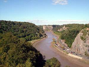
A view of the
Avon Gorge, designated as an SSSI for both its biological and its geological interest
This is a list of the Sites of Special Scientific Interest (SSSIs) in the former county of Avon, England, United Kingdom. In England the body responsible for designating SSSIs is Natural England, which chooses a site because of its fauna, flora, geological or physiographical features.[1] Although the county of Avon no longer exists, Natural England still uses its former borders to mark one of its Areas of Search. As of 2006, there are 86 sites designated in this Area of Search, of which 38 have been designated due to their biological interest, 39 due to their geological interest, and 9 for both.[2]
Natural England took over the role of designating and managing SSSIs from English Nature in October 2006 when it was formed from the amalgamation of English Nature, parts of the Countryside Agency and the Rural Development Service. Natural England, like its predecessor, uses the 1974–1996 county system[3] and as such the same approach is followed here, rather than splitting these sites between the Somerset and Gloucestershire lists. The data in the table is taken from English Nature in the form of citation sheets for each SSSI.[4]
For other counties, see List of SSSIs by Area of Search.
Sites
| Site name |
Reason for designation |
Area[A] |
Grid reference[B] |
Year in which notified |
Map[C] |
|---|
| Biological interest |
Geological interest |
Hectares |
Acres |
| Ashton Court |
 Y Y |
|
210.3 |
519.7 |
ST553723 |
1998 |
Map |
| Aust Cliff |
|
Y |
5.3 |
13.1 |
ST565894 |
1954 |
Map |
| Avon Gorge |
Y |
Y |
155.4 |
384.0 |
ST560743 |
1952 |
Map |
| Banwell Caves |
Y |
Y |
1.7 |
4.2 |
ST383588 |
1963 |
Map |
| Banwell Ochre Caves |
|
Y |
12.5 |
30.8 |
ST407593 |
1983 |
Map |
| Barnhill Quarry |
|
Y |
3.1 |
7.7 |
ST725827 |
1966 |
Map |
| Barns Batch Spinney |
|
Y |
0.1 |
0.2 |
ST557659 |
1987 |
Map |
| Bickley Wood |
|
Y |
9.5 |
23.5 |
ST644703 |
1988 |
Map |
| Biddle Street, Yatton |
Y |
|
44.8 |
110.7 |
ST423648 |
1994 |
Map |
| Bishop's Hill Wood |
Y |
|
30.6 |
75.6 |
ST733873 |
1984 |
Map |
| Blagdon Lake |
Y |
|
212.7 |
525.6 |
ST515597 |
1971 |
Map |
| Bleadon Hill |
|
Y |
13.5 |
33.4 |
ST705943 |
1999 |
Map |
| Bodkin Hazel Wood |
Y |
|
10.6 |
26.2 |
ST780850 |
1974 |
Map |
| Bourne |
|
Y |
8.5 |
20.9 |
ST484600 |
1992 |
Map |
| Bowlditch Quarry |
|
Y |
0.3 |
0.6 |
ST668558 |
1952 |
Map |
| Brinkmarsh Quarry |
|
Y |
0.5 |
1.2 |
ST674913 |
1974 |
Map |
| Brockley Hall Stables |
Y |
|
0.1 |
0.2 |
ST471669 |
1987 |
Map |
| Brown's Folly |
Y |
Y |
39.9 |
98.5 |
ST793662 |
1974 |
Map |
| Buckover Road Cutting |
|
Y |
1.7 |
4.1 |
ST665906 |
1967 |
Map |
| Burledge Sidelands and Meadows |
Y |
|
48.7 |
120.3 |
ST588587 |
2005 |
Map |
| Burrington Combe |
Y |
Y |
139.1 |
343.8 |
ST478583 |
1952 |
Map |
| Cattybrook Brickpit |
|
Y |
2.2 |
5.5 |
ST594835 |
1989 |
Map |
| Chew Valley Lake |
Y |
|
565.2 |
1,396.6 |
ST570600 |
1971 |
Map |
| Cleaves Wood |
Y |
|
40.4 |
99.8 |
ST758576 |
1988 |
Map |
| Cleeve Wood, Hanham |
Y |
|
8.9 |
21.9 |
ST655703 |
1966 |
Map |
| Clevedon Shore |
|
Y |
0.4 |
0.9 |
ST402719 |
1991 |
Map |
| Combe Down and Bathampton Down Mines |
Y |
|
6.2 |
15.4 |
ST761625 |
1991 |
Map |
| Compton Martin Ochre Mine |
Y |
Y |
0.9 |
2.1 |
ST545570 |
1988 |
Map |
| Congrove Field and The Tumps |
Y |
|
12.5 |
30.8 |
ST713698 |
1991 |
Map |
| Court Hill |
|
Y |
10.5 |
25.8 |
ST436722 |
1997 |
Map |
| Cullimore's Quarry |
|
Y |
0.9 |
2.2 |
ST721927 |
1974 |
Map |
| Damery Road Section |
|
Y |
0.5 |
1.0 |
ST705943 |
1974 |
Map |
| Dolebury Warren |
Y |
|
90.6 |
223.3 |
ST455590 |
1952 |
Map |
| Dundry Main Road South Quarry |
|
Y |
0.7 |
1.8 |
ST566654 |
1974 |
Map |
| Ellenborough Park West |
Y |
|
1.8 |
4.4 |
ST319608 |
1989 |
Map |
| Folly Farm |
Y |
|
3.1 |
7.7 |
ST607604 |
1987 |
Map |
| Goblin Combe |
Y |
|
51.9 |
128.2 |
ST473652 |
1999 |
Map |
| Gordano Valley |
Y |
Y |
161.7 |
399.5 |
ST435730 |
1971 |
Map |
| Ham Green |
|
Y |
1.1 |
2.7 |
ST539738 |
1990 |
Map |
| Hampton Rocks Cutting |
|
Y |
1.3 |
3.2 |
ST779666 |
1990 |
Map |
| Harptree Combe |
Y |
|
13.1 |
32.3 |
ST561558 |
1954 |
Map |
| Hartcliff Rocks Quarry |
|
Y |
1.6 |
3.9 |
ST534662 |
1991 |
Map |
| Hawkesbury Meadow |
Y |
|
3.3 |
8.2 |
ST754874 |
1987 |
Map |
| Hawkesbury Quarry |
|
Y |
0.3 |
0.6 |
ST771873 |
1967 |
Map |
| Hinton Charterhouse Field |
Y |
|
0.3 |
0.8 |
ST764574 |
1991 |
Map |
| Hinton Charterhouse Pit |
|
Y |
0.4 |
1.0 |
ST772573 |
1971 |
Map |
| Hinton Hill, Wellow |
|
Y |
0.3 |
0.6 |
ST757582 |
1996 |
Map |
| Holly Lane |
|
Y |
0.5 |
1.2 |
ST419727 |
1990 |
Map |
| Horseshoe Bend, Shirehampton |
Y |
|
4.5 |
11.0 |
ST542767 |
1999 |
Map |
| Huish Colliery Quarry |
|
Y |
0.8 |
2.1 |
ST695542 |
1985 |
Map |
| Iford Manor |
Y |
|
0.4 |
1.0 |
ST802589 |
1996 |
Map |
| Kenn Church, Kenn Pier & Yew Tree Farm |
|
Y |
15.4 |
38.0 |
ST415689 |
1997 |
Map |
| Kilmersdon Road Quarry |
|
Y |
0.4 |
1.1 |
ST689542 |
1954 |
Map |
| King's Wood and Urchin Wood |
Y |
|
128.1 |
316.5 |
ST454645 |
1990 |
Map |
| Long Dole Wood and Meadows[F] |
Y |
|
9.8 |
24.3 |
ST610562 |
1997 |
Map |
| Lower Woods |
Y |
Y |
280.1 |
692.2 |
ST743876 |
1966 |
Map |
| Lulsgate Quarry |
|
Y |
1.1 |
2.8 |
ST516659 |
1997 |
Map |
| Max Bog |
Y |
|
10.6 |
26.2 |
ST406574 |
1988 |
Map |
| Middle Hope |
Y |
Y |
84.1 |
207.8 |
ST325662 |
1952 |
Map |
| Midger |
Y |
|
65.7 |
162.3 |
ST797895 |
1966 |
Map |
| Monkswood Valley |
Y |
|
30.7 |
75.9 |
ST754710 |
1990 |
Map |
| Newton St. Loe |
|
Y |
2.3 |
5.6 |
ST715657 |
1992 |
Map |
| Nightingale Valley |
|
Y |
5.4 |
13.3 |
ST449751 |
1989 |
Map |
| North Road Quarry, Bath |
|
Y |
0.3 |
0.7 |
ST767646 |
1990 |
Map |
| Plaster's Green Meadows |
Y |
|
4.3 |
10.6 |
ST532611 |
1989 |
Map |
| Portishead Pier to Black Nore |
|
Y |
71.8 |
177.4 |
ST474778 |
1952 |
Map |
| Purn Hill |
Y |
|
6.1 |
15.1 |
ST412630 |
1990 |
Map |
| Puxton Moor |
Y |
|
31.1 |
76.8 |
ST412630 |
1994 |
Map |
| Quarry Steps, Durdham Down [D] |
|
Y |
<0.1 |
<0.1 |
ST573747 |
1990 |
Map |
| Severn Estuary [E] |
Y |
Y |
15,950.0 |
39,410.0 |
ST480830 |
1976 |
Map |
| Shiplate Slait |
Y |
|
33.9 |
83.8 |
ST365567 |
1987 |
Map |
| Slickstones Quarry, Cromhall |
|
Y |
2.7 |
6.6 |
ST704916 |
1966 |
Map |
| Spring Cove Cliffs |
|
Y |
2.0 |
4.9 |
ST310625 |
1952 |
Map |
| St. Catherine's Valley |
Y |
|
156.1 |
385.7 |
ST760725 |
1997 |
Map |
| Steep Holm |
Y |
|
25.5 |
63.0 |
ST228607 |
1952 |
Map |
| Stidham Farm |
|
Y |
17.3 |
42.8 |
ST682684 |
1991 |
Map |
| Tickenham, Nailsea and Kenn Moors |
Y |
|
129.4 |
319.7 |
ST440700 |
1995 |
Map |
| Tytherington Quarry |
|
Y |
0.9 |
2.2 |
ST662888 |
1989 |
Map |
| Uphill Cliff |
Y |
|
19.8 |
48.9 |
ST318583 |
1952 |
Map |
| Upton Coombe |
Y |
|
7.4 |
18.3 |
ST789877 |
1989 |
Map |
| Walton Common |
Y |
|
25.5 |
63.0 |
ST428738 |
1991 |
Map |
| Weston Big Wood |
Y |
|
37.5 |
92.6 |
ST455750 |
1971 |
Map |
| Weston-in-Gordano |
|
Y |
12.6 |
31.0 |
ST452744 |
1993 |
Map |
| Winterbourne Railway Cutting |
|
Y |
2.0 |
4.9 |
ST651799 |
1990 |
Map |
| Writhlington |
|
Y |
0.5 |
1.2 |
ST703553 |
1992 |
Map |
| Yanal Bog |
Y |
|
1.6 |
4.0 |
ST424607 |
1988 |
Map |
Notes
- A Data rounded to one decimal place.
- B Grid reference is based on the British national grid reference system, also known as OSGB36, and is the system used by the Ordnance Survey.[5]
- C Link to maps using the Nature on the Map service provided by Natural England.
- D Size smaller than can be shown with one decimal place. Actual size: 0.006 (ha.) 0.015 (ac.).[4]
- E Incorporates two former SSSIs: Severn Estuary (notified 1976) and part of Brean Down and Uphill Cliff (notified 1952). It was unified as Severn Estuary in 1989. It also overlaps with several other SSSIs:
- The Severn Estuary extends into two other counties and so can be found on lists of SSSIs in Gloucestershire and Somerset.[4]
- F The Long Dole Wood and Meadows site extends into the county of Somerset and so can be found on the list of SSSIs in Somerset.[4]
References
|
|---|
|
| England | |
|---|
|
| Scotland | |
|---|
|
| Wales | |
|---|
|
| Northern Ireland | |
|---|