List of Mongol states
| History of the Mongols |
|---|
|
Timeline · History · Rulers · Nobility Culture · Language · Proto-Mongols |
|
|
|
This is a list of Mongol states. The Mongols founded many states such as the vast Mongol Empire and other states. The list of states is chronological but follows the development of different dynasties.
Pre-modern states
| Name | Years | Area | Map | Capital | |||||
|---|---|---|---|---|---|---|---|---|---|
| Khanates in the X-XII centuries | |||||||||
| Khamag Mongol Khanate | 900s–1206 | 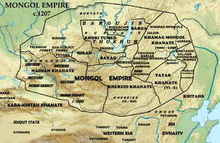 | |||||||
| Merkit Khanate | XI–mid XII | ||||||||
| Kerait Khanate | −1203 | ||||||||
| Naiman Khanate | −1204 | ||||||||
| Tatar Khanate | VI—X/(IX – mid XII?) | ||||||||
| Mongol Empire | 1206–1368 | 33,000,000 km2[1] | 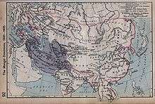 |
Avarga (1206–35) Karakorum (1235–60) Khanbaliq (1260–1368) | |||||
| Yuan dynasty | 1271–1368 | 14,000,000 km2 (1310)[2] |  |
Khanbaliq (Dadu, Beijing) | |||||
| | |||||||||
| Golden Horde | 1240–1502 | 6,000,000 km2 (1310)[3] |  |
Sarai Batu | |||||
| Great Horde | 1466–1502 | ||||||||
| | |||||||||
| Chagatai Khanate | 1225–1340s | 3,500,000 km2 (1310)[3][2] |  |
Almaliq Qarshi | |||||
| Western Chagatai Khanate | 1340s–1370 | ||||||||
| Moghulistan | 1340–1462 |  |
|||||||
| Kara Del Khanate | 1383–1513 | ||||||||
| Ilkhanate | 1256–1335 | 3,750,000 km2 [3][2] |
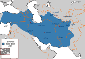 |
Maragha (1256–1265) Tabriz (1265–1306) Soltaniyeh (1306–1335) | |||||
| Chobanids | 1335–1357 |  |
Tabriz | ||||||
| Injuids | 1335–1357 | Baghdad (Till 1411) Basra (1411–1432) | |||||||
| Jalayirid Sultanate | 1335–1432 | Baghdad (Till 1411) Basra (1411–1432) | |||||||
| Arghun dynasty | 1479?–1599? | ||||||||
| Genghisid Northern Yuan dynasty | |||||||||
| Northern Yuan dynasty |
1368–1691 | 5,000,000 km2 (1550)[2] | |
Shangdu (1368–69) Yingchang (1369–70) Karakorum (1371–88) | |||||
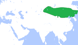
| Khotogoid Khanate (subject of the Northern Yuan) |
late 16th – late 17th century |  |
in Mongolia | ||||||
| Oirats – Non-Genghisid states | |||||||||
| Four Oirat | 1399–1634 | 1,000,000 km2 (15th – late 16th) ~1,600,000 km2 (early 17th century) |
|
||||||
| Zunghar Khanate | 1634–1758 | 3,500,000—4,000,000 km2 | |
||||||
| Khoshut Khanate | 1642?–1717 | ~1,400,000 km2 | |||||||
| Kalmyk Khanate | 1630–1771 | ||||||||
| Timurid states (Persianate Turco-Mongol states) | |||||||||
| Timurid Empire | 1370–1507 | 4,400,000 km2 (1405)[1] | .GIF) |
Samarkand (1370–1505) Herat(1505–1507) | |||||
| Mughal Empire | 1526–1857 | 3,200,000 km2 (1700) |  |
Agra (1526–1571) Fatehpur Sikri (1571–1585) Lahore (1585–1598) Agra (1598–1648) Shahjahanabad/Delhi (1648–1857) | |||||
Modern states
| Name | Years | Area | Map | Capital |
|---|---|---|---|---|
| Balagad state (Buryats) |
1919–1926[4][5][6][7] | In Kizhinginsky District, Buryatia | ||
| Republic of Oirat-Kalmyk | 1930 | Kalmykia | ||
| Republic of Southern Mongolia | 1945 | In Inner Mongolia | ||
| (Bogd Khaganate) |
1911–1924 |  |
Ikh Khuree (Ulaanbaatar) | |
| |
1924–1992 | Ulaanbaatar | ||
| |
1992–present | 1,564,115.75 km2 |  |
Autonomous areas
In Russia
| Name | Years | Capital | Area | Map |
|---|---|---|---|---|
| State of Buryat-Mongolia | 1917–1921 | Chita | ||
| Mongol-Buryat Autonomous Oblast | 1922–1923 | |||
| Buryat-Mongol Autonomous Oblast | 1921–1923 | |||
| Buryat-Mongol Autonomous Soviet Socialist Republic | 1923–1958 | Ulan-Ude | 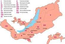 | |
| Buryat Autonomous Soviet Socialist Republic | 1958–1992 | .svg.png) | ||
| Republic of Buryatia | 1992–present | 351,300 km2 | ||
| Agin Buryat-Mongol National Okrug | 1937–1958 | Aginskoye | .svg.png) | |
| Agin-Buryat National Okrug | 1958–1977 | |||
| Agin-Buryat Autonomous Okrug | 1977–2008 | 9,6002 | ||
| Ust-Orda Buryat-Mongolian Autonomous Okrug | 1937–1958 | Ust-Ordynsky |  | |
| Ust-Orda Buryat National Okrug | 1958–1978 | |||
| Ust-Orda Buryat Autonomous Okrug | 1978–2008 | 22,1382 | ||
| Kalmyk Autonomous Oblast | 1920–1935 1957–1958 |
Astrakhan (till 1928) Elista |
 | |
| Kalmyk Autonomous Soviet Socialist Republic | 1935–1943 1958–1990 |
Elista (Elstei) |
.svg.png) | |
| Kalmyk Soviet Socialist Republic | 1990–1992 | |||
| Kalmyk Republic-Halmg-Tangch | 1992–1994 | |||
| Kalmyk Republic | 1994–present | 76,100 km2 |
In China
.svg.png)
.png)

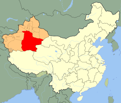

.png)
See also
| Wikimedia Commons has media related to Maps of the history of Mongolia. |
- History of Mongolia
- Timeline of Mongolian history
- List of Mongol rulers
- List of heads of state of Mongolia
Maps
 Rouran Khaganate c. 500
 Rouran Khaganate, Northern Wei, Tuyuhun Kingdom, Southern Liang, Later Yan, Yueban and Northern Liang, 400 AD
 Rouran, Northern Wei, Tuyuhun Kingdom, 500 AD
 Liao dynasty c. 1000
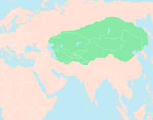 Mongol Empire in 1227
 Mongol Empire
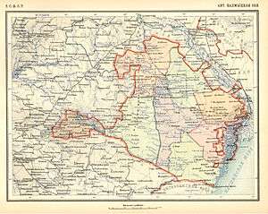
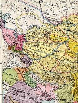 The Dzungar Khanate (c. 1750) (in blue line)
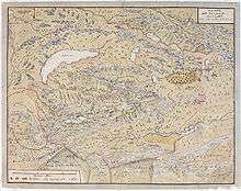 A map of the Dzungar Khanate, by a Swedish officer in captivity there in 1716-1733, which include the region known today as Zhetysu
 The Dzungar Khanate (a fragment of the map of Russian Empire of Peter The Great, that was created by a Sweden soldier in c. 1725)
 This map fragment shows territories of the Dzungar Khanate as in 1706. (Map Collection of the Library of Congress: "Carte de Tartarie" of Guillaume de L'Isle (1675-1726))
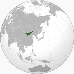
.svg.png) Mongolia
Mongolia Mongolia
References
- 1 2 Turchin, Peter; Adams, Jonathan M.; Hall, Thomas D. (2015). "East-West Orientation of Historical Empires and Modern States". Journal of World-Systems Research. 12 (2): 219. doi:10.5195/jwsr.2006.369. ISSN 1076-156X.

- 1 2 3 4 Rein Taagepera (September 1997). "Expansion and Contraction Patterns of Large Polities: Context for Russia". International Studies Quarterly 41 (3): 475–504.
- 1 2 3 Jonathan M. Adams, Thomas D. Hall and Peter Turchin (2006). East-West Orientation of Historical Empires.Journal of World-Systems Research (University of Connecticut). 12 (no. 2): 219–229.
- ↑ Бидия Дандарон (Russian)
- ↑ Балагатское движение (Russian)
- ↑ Теократическое движение в Хоринском ведомстве Бурятии :1919–1926 гг. (Russian)
- ↑ БАЛАГАТСКОЕ ДВИЖЕНИЕ (Russian)
Bibliography
- Andrews, Peter A. (1999). Felt tents and pavilions: the nomadic tradition and its interaction with princely tentage, Volume 1. Melisende. ISBN 1-901764-03-6.
- Janhunen, Juha (2003a). "Proto-Mongolic". In Janhunen, J. The Mongolic languages. pp. 1–29.
- Janhunen, Juha (2003b). "Para-Mongolic". In Janhunen, J. The Mongolic languages. pp. 391–402.
- Weiers, Michael (ed.) (1986): Die Mongolen. Darmstadt: Wissenschaftliche Buchgesellschaft.
- Dughlát Muhammad Haidar, Norbert Elias, Edward Denison Ross – The Tarikh-i-rashidi
- Henry Hoyle Howorth-History of the Mongols
- Herbert Franke, Denis Twitchett, John King Fairbank -The Cambridge History of China: Alien regimes and border states, 907–1368
- William Bayne Fisher, Peter Jackson, Laurence Lockhart, J. A. Boyle -The Cambridge history of Iran, 5
- Konstantin Nikolaevich Maksimov – Kalmykia in Russia's past and present national policies and administrative system
This article is issued from Wikipedia - version of the 10/4/2016. The text is available under the Creative Commons Attribution/Share Alike but additional terms may apply for the media files.