List of Liverpool Docks

Old map Dkbkpl26: sequence N05—N09
Old map Dkbkpl27: sequence N08—N14
Old map Dkbkpl28: sequence S04—S07
Old map Dkbkpl29: sequence S12—S17
Old map Dkbkpl30: sequence S17—S19

Table of docks (past and present) in the Port of Liverpool, Liverpool, England.

The table can be sorted on each of its columns by clicking the small box in the header. The sequence runs from North (N01) to South (S19). (Using references: [1] [2] [3] [4] [5] [6] [7] [8] [9] .)

Point Coordinates
(Links to map resources)
Sequence
N→S
Notes
Seaforth Dock[6] 53°27′33″N 3°01′30″W / 53.4592°N 3.0250°W / 53.4592; -3.0250 (Seaforth Dock) N01
Gladstone Dock[6] 53°27′18″N 3°01′08″W / 53.4549°N 3.0189°W / 53.4549; -3.0189 (Gladstone Dock) N02
Hornby Dock[6] 53°27′06″N 3°00′46″W / 53.4518°N 3.0129°W / 53.4518; -3.0129 (Hornby Dock) N03 filled-in
Alexandra Dock[6] 53°26′51″N 3°00′43″W / 53.4474°N 3.0120°W / 53.4474; -3.0120 (Alexandra Dock) N04 Google Map wrong
Langton Dock[1] 53°26′37″N 3°00′33″W / 53.4436°N 3.0092°W / 53.4436; -3.0092 (Langton Dock) N05 Google Map wrong
Brocklebank Dock[1] 53°26′28″N 3°00′23″W / 53.4412°N 3.0065°W / 53.4412; -3.0065 (Brocklebank Dock) N06
Carrier Dock[1] 53°26′25″N 3°00′10″W / 53.4403°N 3.0027°W / 53.4403; -3.0027 (Carrier Dock) N07 filled-in; next to Brocklebank Dock
Canada Dock[1] 53°26′11″N 3°00′18″W / 53.4365°N 3.0050°W / 53.4365; -3.0050 (Canada Dock) N08
Huskisson Dock[2] 53°25′54″N 3°00′19″W / 53.4316°N 3.0052°W / 53.4316; -3.0052 (Huskisson Dock) N09
Sandon Dock[2] 53°25′42″N 3°00′05″W / 53.4283°N 3.0015°W / 53.4283; -3.0015 (Sandon Dock) N10 filled-in
Sandon Half Tide Dock[2] 53°25′40″N 3°00′18″W / 53.4277°N 3.0050°W / 53.4277; -3.0050 (Sandon Half Tide Dock) N11
Wellington Dock[2] 53°25′36″N 3°00′06″W / 53.4267°N 3.0016°W / 53.4267; -3.0016 (Wellington Dock) N12 to be filled in
Bramley-Moore Dock[2] 53°25′30″N 3°00′11″W / 53.4250°N 3.0030°W / 53.4250; -3.0030 (Bramley-Moore Dock) N13
Nelson Dock[2] 53°25′24″N 3°00′12″W / 53.4233°N 3.0032°W / 53.4233; -3.0032 (Nelson Dock) N14
Salisbury Dock[7] 53°25′17″N 3°00′14″W / 53.4215°N 3.0038°W / 53.4215; -3.0038 (Salisbury Dock) N15
Collingwood Dock[7] 53°25′18″N 3°00′06″W / 53.4216°N 3.0016°W / 53.4216; -3.0016 (Collingwood Dock) N16
Stanley Dock[7] 53°25′18″N 2°59′55″W / 53.4216°N 2.9985°W / 53.4216; -2.9985 (Stanley Dock) N17
Clarence Dock[8] 53°25′09″N 3°00′07″W / 53.4191°N 3.0019°W / 53.4191; -3.0019 (Clarence Dock) N18 filled-in; next to Trafalgar Dock
Trafalgar Dock[7] 53°25′06″N 3°00′14″W / 53.4183°N 3.0039°W / 53.4183; -3.0039 (Trafalgar Dock) N19 mostly filled in
Victoria Dock[8] 53°24′56″N 3°00′05″W / 53.4155°N 3.0014°W / 53.4155; -3.0014 (Victoria Dock) N20 filled-in
West Waterloo Dock[7] 53°24′50″N 3°00′08″W / 53.4140°N 3.0022°W / 53.4140; -3.0022 (West Waterloo Dock) N21 reduced to inland canal boat depth
East Waterloo Dock[7] 53°24′51″N 3°00′02″W / 53.4142°N 3.0005°W / 53.4142; -3.0005 (East Waterloo Dock) N22
Prince's Half-Tide Dock[7] 53°24′44″N 3°00′03″W / 53.4122°N 3.0007°W / 53.4122; -3.0007 (Princes Half Tide Dock) N23 reduced to inland canal boat depth
Prince's Dock[7] 53°24′33″N 2°59′57″W / 53.4091°N 2.9991°W / 53.4091; -2.9991 (Princes Dock) N24 reduced to inland canal boat depth
George's Basin[8] 53°24′23″N 2°59′48″W / 53.4063°N 2.9968°W / 53.4063; -2.9968 (George's Basin) S01 filled-in; approx location
George's Dock[8] 53°24′18″N 2°59′43″W / 53.4050°N 2.9954°W / 53.4050; -2.9954 (George's Dock) S02
Manchester Dock 53°24′11″N 2°59′42″W / 53.4031°N 2.9949°W / 53.4031; -2.9949 (Manchester Dock) S03 filled-in
Canning Dock[3] 53°24′09″N 2°59′30″W / 53.4026°N 2.9918°W / 53.4026; -2.9918 (Canning Dock) S04
Old Dock[9] 53°24′09″N 2°59′19″W / 53.4025°N 2.9886°W / 53.4025; -2.9886 (Old Dock) S05 filled-in; approx location
Canning Half Tide Dock[3] 53°24′06″N 2°59′37″W / 53.4018°N 2.9937°W / 53.4018; -2.9937 (Canning Half Tide Dock) S06
Albert Dock[3] 53°24′01″N 2°59′34″W / 53.4003°N 2.9927°W / 53.4003; -2.9927 (Albert Dock) S07
Salthouse Dock[3] 53°24′02″N 2°59′23″W / 53.4006°N 2.9898°W / 53.4006; -2.9898 (Salthouse Dock) S08
Duke's Dock[7] 53°23′56″N 2°59′27″W / 53.3988°N 2.9907°W / 53.3988; -2.9907 (Dukes Dock) S09
King's Dock[7] 53°23′48″N 2°59′24″W / 53.3967°N 2.9900°W / 53.3967; -2.9900 (King's Dock) S10 filled-in
Wapping Dock[7] 53°23′50″N 2°59′15″W / 53.3971°N 2.9874°W / 53.3971; -2.9874 (Wapping Dock) S11
Queen's Dock[4][7] 53°23′38″N 2°59′07″W / 53.3940°N 2.9854°W / 53.3940; -2.9854 (Queen's Dock) S12
Coburg Dock[4] 53°23′29″N 2°59′06″W / 53.3914°N 2.9851°W / 53.3914; -2.9851 (Coburg Dock) S13
South Ferry Basin[7] 53°23′25″N 2°59′14″W / 53.3902°N 2.9873°W / 53.3902; -2.9873 (South Ferry Basin) S14
Brunswick Half Tide Dock[4] 53°23′19″N 2°59′07″W / 53.3887°N 2.9854°W / 53.3887; -2.9854 (Brunswick Half Tide Dock) S15
Brunswick Dock[4] 53°23′20″N 2°59′00″W / 53.3888°N 2.9833°W / 53.3888; -2.9833 (Brunswick Dock) S16
Toxteth Dock[5] 53°23′02″N 2°58′47″W / 53.3839°N 2.9797°W / 53.3839; -2.9797 (Toxteth Dock) S17 filled in
Harrington Dock[5] 53°22′51″N 2°58′31″W / 53.3808°N 2.9753°W / 53.3808; -2.9753 (Harrington Dock) S18 filled in
Herculaneum Dock[5] 53°22′43″N 2°58′12″W / 53.3786°N 2.9701°W / 53.3786; -2.9701 (Herculaneum Dock) S19 filled in

References

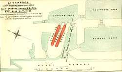
  1. 1 2 3 4 5 Old map: Mersey Docks and Harbour Board Docks, c. 1909, File:Dkbkpl26.jpg
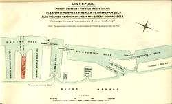
  2. 1 2 3 4 5 6 7 Old map: Mersey Docks and Harbour Board Docks, c. 1909, File:Dkbkpl27.jpg
  3. 1 2 3 4 5 Old map: Mersey Docks and Harbour Board Docks, c. 1909, File:Dkbkpl28.jpg
  4. 1 2 3 4 5 Old map: Mersey Docks and Harbour Board Docks, c. 1909, File:Dkbkpl29.jpg
  5. 1 2 3 4 Old map: Mersey Docks and Harbour Board Docks, c. 1909, File:Dkbkpl30.jpg
  6. 1 2 3 4 5 Port of Liverpool: Map
  7. 1 2 3 4 5 6 7 8 9 10 11 12 13 14 Pevsner Architectural Guides - Liverpool, Joseph Sharples, 2004, ISBN 0-300-10258-5
  8. 1 2 3 4 5 Liverpool 2007: North Docks
  9. 1 2 Liverpool 2007: South Docks
This article is issued from Wikipedia - version of the 10/16/2016. The text is available under the Creative Commons Attribution/Share Alike but additional terms may apply for the media files.