List of Category A listed buildings in East Ayrshire

This is a list of Category A listed buildings in East Ayrshire, Scotland.
In Scotland, the term listed building refers to a building or other structure officially designated as being of "special architectural or historic interest".[1] Category A structures are those considered to be "buildings of national or international importance, either architectural or historic, or fine little-altered examples of some particular period, style or building type."[2] Listing was begun by a provision in the Town and Country Planning (Scotland) Act 1947, and the current legislative basis for listing is the Planning (Listed Buildings and Conservation Areas) (Scotland) Act 1997.[3] The authority for listing rests with Historic Scotland, an executive agency of the Scottish Government, which inherited this role from the Scottish Development Department in 1991. Once listed, severe restrictions are imposed on the modifications allowed to a building's structure or its fittings. Listed building consent must be obtained from local authorities prior to any alteration to such a structure.[3] There are approximately 47,400 listed buildings in Scotland, of which around 8% (some 3,800) are Category A.[4]
The council area of East Ayrshire covers 1,262 square kilometres (487 sq mi), and has a population of around 119,900. There are 45 Category A listed buildings in the area.
Listed buildings


Notes
- ↑ Sometimes known as OSGB36, the grid reference (where provided) is based on the British national grid reference system used by the Ordnance Survey.
• "Guide to National Grid". Ordnance Survey. Retrieved 2007-12-12.
• "Get-a-map". Ordnance Survey. Retrieved 2007-12-17. - ↑ The "HB Number" is a unique number assigned to each listed building by Historic Scotland.
References
- ↑ Guide to the Protection of Scotland’s Listed Buildings (PDF). Historic Scotland. 2009. p. 4. ISBN 978-1-84917-013-0. Retrieved 2010-05-05.
- ↑ "What is Listing?". Historic Scotland. Retrieved 2010-05-05.
- 1 2 Scottish Historic Environment Policy (PDF). Historic Scotland. October 2008. pp. 24–25. ISBN 978-1-84917-002-4. Retrieved 2010-05-05.
- ↑ Guide to the Protection of Scotland’s Listed Buildings, p. 17.
- ↑ "The Temple, in Policies of Dumfries House: Listed Building Report". Historic Scotland. Retrieved 2010-06-05.
- ↑ "Auchinleck House: Listed Building Report". Historic Scotland. Retrieved 2010-06-05.
- ↑ "Waterside Engine House: Listed Building Report". Historic Scotland. Retrieved 2010-06-05.
- ↑ "The Hill, with ancillary buildings, boundary walls, gates and gatepiers: Listed Building Report". Historic Scotland. Retrieved 2010-06-05.
- ↑ "Dunlop House With Bridge: Listed Building Report". Historic Scotland. Retrieved 2010-06-05.
- ↑ "Main Street, Parish Church Graveyard, Hans Hamilton's Tomb: Listed Building Report". Historic Scotland. Retrieved 2010-06-05.
- ↑ "Main Street, Clandeboye School: Listed Building Report". Historic Scotland. Retrieved 2010-06-05.
- ↑ "62 Main Street, Kirkland, with former coach house and stables, boundary wall, gates and gatepiers: Listed Building Report". Historic Scotland. Retrieved 2010-06-05.
- ↑ "Rowallan Castle: Listed Building Report". Historic Scotland. Retrieved 2010-06-05.
- ↑ "Rowallan House: Listed Building Report". Historic Scotland. Retrieved 2010-06-05.
- ↑ "Crawfurdland Castle: Listed Building Report". Historic Scotland. Retrieved 2010-06-05.
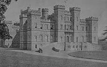
- ↑ "Loudoun Castle: Listed Building Report". Historic Scotland. Retrieved 2010-06-05.
- ↑ "Disused Railway Viaduct Near West Gatehead: Listed Building Report". Historic Scotland. Retrieved 2010-06-05.
- ↑ "Cessnock Castle: Listed Building Report". Historic Scotland. Retrieved 2010-06-05.
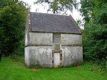
- ↑ "Dovecote, Tour Garden: Listed Building Report". Historic Scotland. Retrieved 2010-06-05.
- ↑ "Tolbooth: Listed Building Report". Historic Scotland. Retrieved 2010-06-05.
- ↑ "Alexander Morton Monument, beside A71 between Newmilns and Darvel: Listed Building Report". Historic Scotland. Retrieved 2010-06-05.
- ↑ "Sornhill Farm: Listed Building Report". Historic Scotland. Retrieved 2010-06-05.
- ↑ "Catrine Parish Church: Listed Building Report". Historic Scotland. Retrieved 2010-06-05.
- ↑ "Bridge over River Ayr, opposite Sorn Parish Church: Listed Building Report". Historic Scotland. Retrieved 2010-06-05.
- ↑ "Sorn Castle: Listed Building Report". Historic Scotland. Retrieved 2010-06-05.
- ↑ "Stables, Sorn Castle: Listed Building Report". Historic Scotland. Retrieved 2010-06-05.
- ↑ "Stair Bridge: Listed Building Report". Historic Scotland. Retrieved 2010-06-05.
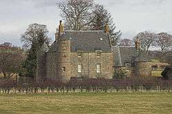
- ↑ "Stair House: Listed Building Report". Historic Scotland. Retrieved 2010-06-05.
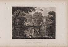
- ↑ "Dumfries House: Listed Building Report". Historic Scotland. Retrieved 2010-06-05.
- ↑ "Avenue Bridge, Dumfries House Policies: Listed Building Report". Historic Scotland. Retrieved 2010-06-05.
- ↑ "Dovecote, Dumfries House: Listed Building Report". Historic Scotland. Retrieved 2010-06-05.
- ↑ "Mauchline Castle (Abbot Hunter's Tower): Listed Building Report". Historic Scotland. Retrieved 2010-06-05.
- ↑ "Ballochmyle Railway Viaduct: Listed Building Report". Historic Scotland. Retrieved 2010-06-05.
- ↑ "Kennox: Listed Building Report". Historic Scotland. Retrieved 2010-06-05.
- ↑ "High Williamshaw: Listed Building Report". Historic Scotland. Retrieved 2010-06-05.
- ↑ "Dovecote, Treesbank: Listed Building Report". Historic Scotland. Retrieved 2010-06-05.
- ↑ "Caprington Castle: Listed Building Report". Historic Scotland. Retrieved 2010-06-05.
- ↑ "Craigengillan: Listed Building Report". Historic Scotland. Retrieved 2010-06-05.
- ↑ "Craigengillan, stables: Listed Building Report". Historic Scotland. Retrieved 2010-06-05.
- ↑ "Loch Doon Castle: Listed Building Report". Historic Scotland. Retrieved 2010-06-05.
- ↑ "Barskimming New Bridge, including estate workers' houses and viewing platform: Listed Building Report". Historic Scotland. Retrieved 2010-06-05.
- ↑ "Mercat Cross, The Square: Listed Building Report". Historic Scotland. Retrieved 2010-06-05.
- ↑ "Bank (or Templand) Railway Viaduct over Lugar Water in Woodroad Park: Listed Building Report". Historic Scotland. Retrieved 2010-06-05.
- ↑ "R.C. Church of St. Sophia: Listed Building Report". Historic Scotland. Retrieved 2010-06-05.
- ↑ "Bank Street, The Laigh Kirk: Listed Building Report". Historic Scotland. Retrieved 2010-06-05.
- ↑ "Dean Road, Dean Castle and Gatehouse: Listed Building Report". Historic Scotland. Retrieved 2010-06-05.
- ↑ "Green Street, Palace Theatre, former Corn Exchange: Listed Building Report". Historic Scotland. Retrieved 2010-06-05.
- ↑ "Portland Road, Holy Trinity Episcopal Church including hall, boundary walls, gatepiers and milestone: Listed Building Report". Historic Scotland. Retrieved 2010-06-05.
- ↑ "Soulis Street, High Church (Church of Scotland), including churchyard, walls, gatepiers and Soulis Monument: Listed Building Report". Historic Scotland. Retrieved 2010-06-05.
External links
![]() Media related to Category A listed buildings in East Ayrshire at Wikimedia Commons
Media related to Category A listed buildings in East Ayrshire at Wikimedia Commons