| Alberta Parks |
|
| Type | Number | Area km²
(sq mi) |
| Provincial Parks | 76 | 2,214 km2 (855 sq mi) |
| Wildland Provincial Parks | 31 | 17,314 km2 (6,685 sq mi) |
| Provincial Recreation Areas | 208 | 899 km2 (347 sq mi) |
| Wilderness Areas | 3 | 1,010 km2 (390 sq mi) |
| Ecological Reserves | 15 | 268 km2 (103 sq mi) |
| Natural Areas | 139 | 1,299 km2 (502 sq mi) |
| Heritage Rangelands | 2 | 120 km2 (46 sq mi) |
| National Parks | 5 | 63,045 km2 (24,342 sq mi) |
| Total | 476 | 90,747 km2 (35,038 sq mi) |
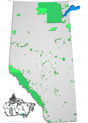
This is a list of protected areas of Alberta. Protected areas are managed by the Government of Canada or the Government of Alberta. The provincial government owns 60% of Alberta's landmass[1] but most of this has not been formally protected. The total protected area throughout Alberta including federal and provincial protected areas is approximately 90,700 km2 (35,000 sq mi).
International recognition
Five of Canada's thirteen World Heritage Sites are located in Alberta: Canadian Rocky Mountain Parks (partly in British Columbia), Dinosaur Provincial Park, Head-Smashed-In Buffalo Jump, Waterton-Glacier International Peace Park (partly in the USA) and Wood Buffalo National Park (partly in the Northwest Territories).
Federally protected areas
Five National Parks of Canada (Banff, Elk Island, Jasper, Waterton Lakes and Wood Buffalo), managed by Parks Canada are located in the province. Several former national parks (such Buffalo National Park, Wawaskesy National Park, and Nemiskam National Park) formerly existed in Alberta, but were delisted in 1947.
Provincially protected areas
There are several different departments and agencies that deal with land use in Alberta, however Alberta's provincial parks are managed by the Government of Alberta's Tourism, Parks, and Recreation ministry whose mandate is to protect the province's natural landscapes in Alberta. The government has divided these natural areas into seven categories, provincial parks being one. These categories are:
As of 2016, the province of Alberta managed 76 provincial parks, 32 wildland provincial parks, 208 provincial recreation areas, 15 ecological reserves, 3 wilderness areas, 139 natural areas and 2 heritage rangeland.[2] Although these areas are the responsibility of the Alberta government, private companies have been contracted to handle various aspects of the operation of many parks (e.g. maintenance and campground operation).
List of wilderness areas
Wilderness areas have the strictest level of protection, no development of any kind is permitted, and travel is only permitted by foot.[3]
List of provincial parks
| Park | Nearest Community | Established | Coordinates | website (ID) |
| Antelope Hill Provincial Park |
Hanna | 2014, December 4[4] | | |
| Aspen Beach Provincial Park |
Bentley | 1932, November 21 | 52°27′28″N 113°58′39″W / 52.45778°N 113.97750°W / 52.45778; -113.97750 (Aspen Beach Provincial Park) | 1 |
| Beauvais Lake Provincial Park |
Pincher Creek | 1954, February 1 | 49°24′39″N 114°06′33″W / 49.41083°N 114.10917°W / 49.41083; -114.10917 (Beauvais Lake Provincial Park) | 6 |
| Big Hill Springs Provincial Park |
Cochrane | 1957, November 22 | 51°15′6″N 114°23′18″W / 51.25167°N 114.38833°W / 51.25167; -114.38833 (Big Hill Springs Provincial Park) | 12 |
| Big Knife Provincial Park |
Forestburg | 1962, October 2 | 52°29′25″N 112°13′15″W / 52.49028°N 112.22083°W / 52.49028; -112.22083 (Big Knife Provincial Park) | 11 |
| Bow Valley Provincial Park |
Canmore | 1959, July 27 | 51°04′5″N 115°02′47″W / 51.06806°N 115.04639°W / 51.06806; -115.04639 (Bow Valley Provincial Park) | 293 |
| Bragg Creek Provincial Park |
Bragg Creek | 1960, January 19 | 50°56′30″N 114°35′14″W / 50.94167°N 114.58722°W / 50.94167; -114.58722 (Bragg Creek Provincial Park) | 324 |
| Brown-Lowery Provincial Park |
Turner Valley | 1992, October 29 | 50°48′58″N 114°26′4″W / 50.81611°N 114.43444°W / 50.81611; -114.43444 (Brown-Lowery Provincial Park) | 16 |
| Calling Lake Provincial Park |
Athabasca | 1971, July 20 | 55°10′51″N 113°14′40″W / 55.18083°N 113.24444°W / 55.18083; -113.24444 (Calling Lake Provincial Park) | 248 |
| Canmore Nordic Centre Provincial Park |
Canmore | 1988 | 51°05′53″N 115°23′23″W / 51.09806°N 115.38972°W / 51.09806; -115.38972 (Canmore Nordic Centre Provincial Park) | 294 |
| Carson-Pegasus Provincial Park |
Whitecourt | 1982, May 19 | 54°18′16″N 115°38′30″W / 54.30444°N 115.64167°W / 54.30444; -115.64167 (Carson-Pegasus Provincial Park) | 247 |
| Chain Lakes Provincial Park |
Nanton | 1969, December 23 | 50°12′24″N 114°11′47″W / 50.20667°N 114.19639°W / 50.20667; -114.19639 (Chain Lakes Provincial Park) | 19 |
| Cold Lake Provincial Park |
Cold Lake | 1976, August 18 | 54°27′38″N 110°07′12″W / 54.46056°N 110.12000°W / 54.46056; -110.12000 (Cold Lake Provincial Park) | 22 |
| Crimson Lake Provincial Park |
Rocky Mountain House | 1955, November 22 | 52°27′0″N 115°2′0″W / 52.45000°N 115.03333°W / 52.45000; -115.03333 (Crimson Lake Provincial Park) | 27 |
| Cross Lake Provincial Park |
Athabasca | 1955, November 22 | 54°38′17″N 113°48′52″W / 54.63806°N 113.81444°W / 54.63806; -113.81444 (Cross Lake Provincial Park) | 28 |
| Crow Lake Provincial Park |
Fort McMurray | | 55°47′47″N 112°10′54″W / 55.79639°N 112.18167°W / 55.79639; -112.18167 (Crow Lake Provincial Park) | 574 |
| Cypress Hills Interprovincial Park |
Medicine Hat | | 49°34′31″N 110°00′23″W / 49.57528°N 110.00639°W / 49.57528; -110.00639 (Cypress Hills Interprovincial Park) | 29 |
| Dillberry Lake Provincial Park |
Provost | 1957, January 8 | 52°35′47″N 110°04′51″W / 52.59639°N 110.08083°W / 52.59639; -110.08083 (Dillberry Lake Provincial Park) | 38 |
| Dinosaur Provincial Park |
Brooks | 1955, June 27 | 50°45′44″N 111°31′5″W / 50.76222°N 111.51806°W / 50.76222; -111.51806 (Dinosaur Provincial Park) | 246 |
| Dry Island Buffalo Jump Provincial Park |
Trochu | 1970, December 15 | 51°56′10″N 112°57′41″W / 51.93611°N 112.96139°W / 51.93611; -112.96139 (Dry Island Buffalo Jump Provincial Park) | 39 |
| Dunvegan Provincial Park |
Fairview | 1992, May 21 | 55°55′24″N 118°36′2″W / 55.92333°N 118.60056°W / 55.92333; -118.60056 (Dunvegan Provincial Park) | 40 |
| Eagle Point Provincial Park |
Drayton Valley | 2007, August 29 | 53°14′40″N 114°52′28″W / 53.24444°N 114.87444°W / 53.24444; -114.87444 (Eagle Point Provincial Park) | 589 |
| Fish Creek Provincial Park |
Calgary | 1975, June 10 | 50°54′11″N 114°00′55″W / 50.90306°N 114.01528°W / 50.90306; -114.01528 (Fish Creek Provincial Park) | 45 |
| Garner Lake Provincial Park |
Vilna | 1953, July 14 | 54°10′59″N 111°44′22″W / 54.18306°N 111.73944°W / 54.18306; -111.73944 (Garner Lake Provincial Park) | 49 |
| Glenbow Ranch Provincial Park |
Calgary
Cochrane | 2008, April 17 | 51°10′1″N 114°23′34″W / 51.16694°N 114.39278°W / 51.16694; -114.39278 (Glenbow Ranch Provincial Park) | 593 |
| Gooseberry Lake Provincial Park |
Consort | 1932, November 21 | 52°07′4″N 110°45′6″W / 52.11778°N 110.75167°W / 52.11778; -110.75167 (Gooseberry Lake Provincial Park) | 51 |
| Greene Valley Provincial Park |
Peace River | 2000, June 6 | 56°11′53″N 117°14′30″W / 56.19806°N 117.24167°W / 56.19806; -117.24167 (Greene Valley Provincial Park) | 147 |
| Gregoire Lake Provincial Park |
Fort McMurray | 1969, October 21 | 56°28′23″N 111°11′55″W / 56.47306°N 111.19861°W / 56.47306; -111.19861 (Gregoire Lake Provincial Park) | 52 |
| Hilliard's Bay Provincial Park |
High Prairie | 1978, October 24 | 55°29′57″N 116°01′10″W / 55.49917°N 116.01944°W / 55.49917; -116.01944 (Hilliard's Bay Provincial Park) | 3 |
| Jarvis Bay Provincial Park |
Sylvan Lake | 1965, July 8 | 52°21′59″N 114°07′56″W / 52.36639°N 114.13222°W / 52.36639; -114.13222 (Jarvis Bay Provincial Park) | 61 |
| Kinbrook Island Provincial Park |
Brooks | 1951, November 14 | 50°26′52″N 111°54′40″W / 50.44778°N 111.91111°W / 50.44778; -111.91111 (Kinbrook Island Provincial Park) | 65 |
| Lakeland Provincial Park |
Lac La Biche | 1992, January 16 | 54°47′24″N 111°29′17″W / 54.79000°N 111.48806°W / 54.79000; -111.48806 (Lakeland Provincial Park) | 280 |
| Lesser Slave Lake Provincial Park |
Slave Lake | | 55°25′3″N 114°48′39″W / 55.41750°N 114.81083°W / 55.41750; -114.81083 (Lesser Slave Lake Provincial Park) | 68 |
| Little Bow Provincial Park |
Champion | 1954, January 20 | 50°13′10″N 112°57′56″W / 50.21944°N 112.96556°W / 50.21944; -112.96556 (Little Bow Provincial Park) | 69 |
| Little Fish Lake Provincial Park |
Drumheller | 1957, April 8 | 51°22′18″N 112°11′54″W / 51.37167°N 112.19833°W / 51.37167; -112.19833 (Little Fish Lake Provincial Park) | 71 |
| Lois Hole Centennial Provincial Park |
Edmonton
St. Albert | 2005, April 19 | 53°36′22″N 113°40′41″W / 53.60611°N 113.67806°W / 53.60611; -113.67806 (Lois Hole Centennial Provincial Park) | 437 |
| Long Lake Provincial Park |
Boyle | 1957, March 25 | 54°25′32″N 112°45′26″W / 54.42556°N 112.75722°W / 54.42556; -112.75722 (Long Lake Provincial Park) | 72 |
| Midland Provincial Park |
Drumheller | 1979, June 5 | 51°28′41″N 112°47′13″W / 51.47806°N 112.78694°W / 51.47806; -112.78694 (Midland Provincial Park) | 78 |
| Miquelon Lake Provincial Park |
Hay Lakes | 1958, May 20 | 53°14′51″N 112°53′15″W / 53.24750°N 112.88750°W / 53.24750; -112.88750 (Miquelon Lake Provincial Park) | 81 |
| Moonshine Lake Provincial Park |
Rycroft | 1959, April 21 | 55°55′31″N 119°13′51″W / 55.92528°N 119.23083°W / 55.92528; -119.23083 (Moonshine Lake Provincial Park) | 82 |
| Moose Lake Provincial Park |
Bonnyville | 1967, April 19 | 54°15′50″N 110°55′55″W / 54.26389°N 110.93194°W / 54.26389; -110.93194 (Moose Lake Provincial Park) | 83 |
| Notikewin Provincial Park |
Manning | 1979, November 20 | 57°17′19″N 117°09′3″W / 57.28861°N 117.15083°W / 57.28861; -117.15083 (Notikewin Provincial Park) | 87 |
| Obed Lake Provincial Park |
Edson | | 53°33′19″N 117°07′44″W / 53.55528°N 117.12889°W / 53.55528; -117.12889 (Obed Lake Provincial Park) | 203 |
| O'Brien Provincial Park |
Grande Prairie | 1954, June 29 | 55°03′49″N 118°49′28″W / 55.06361°N 118.82444°W / 55.06361; -118.82444 (O'Brien Provincial Park) | 88 |
| Park Lake Provincial Park |
Lethbridge | 1932, November 21 | 49°48′14″N 112°55′30″W / 49.80389°N 112.92500°W / 49.80389; -112.92500 (Park Lake Provincial Park) | 143 |
| Pembina River Provincial Park |
Entwistle | 1953, September 21 | 53°36′18″N 114°59′57″W / 53.60500°N 114.99917°W / 53.60500; -114.99917 (Pembina River Provincial Park) | 92 |
| Peter Lougheed Provincial Park |
Kananaskis | 1977, October 7 | 50°41′0″N 115°13′35″W / 50.68333°N 115.22639°W / 50.68333; -115.22639 (Peter Lougheed Provincial Park) | 307 |
| Pierre Grey's Lakes Provincial Park |
Grande Cache | | 53°54′23″N 118°35′18″W / 53.90639°N 118.58833°W / 53.90639; -118.58833 (Pierre Grey's Lakes Provincial Park) | 209 |
| Pigeon Lake Provincial Park |
Wetaskiwin | 1967, May 26 | 53°01′35″N 114°08′4″W / 53.02639°N 114.13444°W / 53.02639; -114.13444 (Pigeon Lake Provincial Park) | 98 |
| Police Outpost Provincial Park |
Cardston | 1970, April 21 | 49°00′22″N 113°27′32″W / 49.00611°N 113.45889°W / 49.00611; -113.45889 (Police Outpost Provincial Park) | 108 |
| Queen Elizabeth Provincial Park |
Grimshaw | 1956, March 1 | 56°13′43″N 117°41′22″W / 56.22861°N 117.68944°W / 56.22861; -117.68944 (Queen Elizabeth Provincial Park) | 110 |
| Ram Falls Provincial Park |
Nordegg | | 52°05′21″N 115°50′11″W / 52.08917°N 115.83639°W / 52.08917; -115.83639 (Ram Falls Provincial Park) | 213 |
| Red Lodge Provincial Park |
Bowden | 1951, May 7 | 51°56′38″N 114°16′11″W / 51.94389°N 114.26972°W / 51.94389; -114.26972 (Red Lodge Provincial Park) | 114 |
| Rochon Sands Provincial Park |
Stettler | 1957, January 8 | 52°27′51″N 112°53′27″W / 52.46417°N 112.89083°W / 52.46417; -112.89083 (Rochon Sands Provincial Park) | 116 |
| Rock Lake Provincial Park |
Hinton | | 53°28′2″N 118°15′10″W / 53.46722°N 118.25278°W / 53.46722; -118.25278 (Rock Lake Provincial Park) | 215 |
| Saskatoon Island Provincial Park |
Wembley | 1932, November 21 | 55°12′20″N 119°05′6″W / 55.20556°N 119.08500°W / 55.20556; -119.08500 (Saskatoon Island Provincial Park) | 118 |
| Sheep River Provincial Park |
Turner Valley | | 50°38′49″N 114°38′43″W / 50.64694°N 114.64528°W / 50.64694; -114.64528 (Sheep River Provincial Park) | 330 |
| Sir Winston Churchill Provincial Park |
Lac La Biche | 1952, September 29 | 54°49′45″N 111°57′45″W / 54.82917°N 111.96250°W / 54.82917; -111.96250 (Sir Winston Churchill Provincial Park) | 120 |
| Spray Valley Provincial Park |
Kananaskis | 2000, December 1 | 50°50′14″N 115°14′48″W / 50.83722°N 115.24667°W / 50.83722; -115.24667 (Spray Valley Provincial Park) | 308 |
| Strathcona Science Provincial Park |
Edmonton
Sherwood Park |
1979, December 12 | 53°33′39″N 113°23′2″W / 53.56083°N 113.38389°W / 53.56083; -113.38389 (Strathcona Science Provincial Park) | 123 |
| Sundance Provincial Park |
Edson | 1999, April 28 | 53°38′29″N 116°52′47″W / 53.64139°N 116.87972°W / 53.64139; -116.87972 (Sundance Provincial Park) | 142 |
| Sylvan Lake Provincial Park |
Sylvan Lake | 1980, January 16 | 52°20′43″N 114°10′11″W / 52.34528°N 114.16972°W / 52.34528; -114.16972 (Sylvan Lake Provincial Park) | 125 |
| Thunder Lake Provincial Park |
Barrhead | 1958, January 28 | 54°07′59″N 114°43′57″W / 54.13306°N 114.73250°W / 54.13306; -114.73250 (Thunder Lake Provincial Park) | 137 |
| Tillebrook Provincial Park |
Tilley | 1965, July 20 | 50°32′16″N 111°48′30″W / 50.53778°N 111.80833°W / 50.53778; -111.80833 (Tillebrook Provincial Park) | 138 |
| Two Lakes Provincial Park |
Grande Prairie | | 54°22′22″N 119°45′31″W / 54.37278°N 119.75861°W / 54.37278; -119.75861 (Two Lakes Provincial Park) | 222 |
| Vermilion Provincial Park |
Vermilion | 1953, May 29 | 53°21′53″N 110°52′55″W / 53.36472°N 110.88194°W / 53.36472; -110.88194 (Vermilion Provincial Park) | 152 |
| Wabamun Lake Provincial Park |
Wabamun | | 53°33′58″N 114°27′16″W / 53.56611°N 114.45444°W / 53.56611; -114.45444 (Wabamun Lake Provincial Park) | 154 |
| Whitney Lakes Provincial Park |
Elk Point | 1982, June 23 | 53°49′48″N 110°29′48″W / 53.83000°N 110.49667°W / 53.83000; -110.49667 (Whitney Lakes Provincial Park) | 158 |
| William A. Switzer Provincial Park |
Hinton | 1958, December 22 | 53°32′34″N 117°48′20″W / 53.54278°N 117.80556°W / 53.54278; -117.80556 (William A. Switzer Provincial Park) | 159 |
| Williamson Provincial Park |
Valleyview | 1960, November 7 | 55°04′52″N 117°33′26″W / 55.08111°N 117.55722°W / 55.08111; -117.55722 (Williamson Provincial Park) | 165 |
| Willow Creek Provincial Park |
Stavely | 1957, December 10 | 50°06′54″N 113°46′14″W / 50.11500°N 113.77056°W / 50.11500; -113.77056 (Willow Creek Provincial Park) | 167 |
| Winagami Lake Provincial Park |
Donnelly | 1956, November 13 | 55°37′45″N 116°40′41″W / 55.62917°N 116.67806°W / 55.62917; -116.67806 (Winagami Lake Provincial Park) | 169 |
| Woolford Provincial Park |
Cardston | | 49°10′33″N 113°11′20″W / 49.17583°N 113.18889°W / 49.17583; -113.18889 (Woolford Provincial Park) | 173 |
| Writing-on-Stone Provincial Park |
Coutts | 1957, January 8 | 49°04′49″N 111°38′21″W / 49.08028°N 111.63917°W / 49.08028; -111.63917 (Writing-on-Stone Provincial Park) | 177 |
| Wyndham-Carseland Provincial Park |
Strathmore | 1979, May 2 | 50°49′47″N 113°26′59″W / 50.82972°N 113.44972°W / 50.82972; -113.44972 (Wyndham-Carseland Provincial Park) | 178 |
| Young's Point Provincial Park |
Valleyview | 1971, August 3 | 55°07′3″N 117°33′29″W / 55.11750°N 117.55806°W / 55.11750; -117.55806 (Young's Point Provincial Park) | 180 |
Other parks
Other provincial lands
Approximately 60% of land in Alberta is public land owned by the Alberta government.[5] For administrative purposes, the province is divided into two broad land use areas: the Green Area (forested land, almost entirely provincially owned) and the White Area (other).[5] The Rocky Mountains Forest Reserve was created by the Forest Reserves Act of 1964.[6] There are also 32 provincial grazing reserves located throughout Alberta. They are administered by Alberta Sustainable Resource Development.[1]
Municipal parks
See also
References
External links
|
|---|
|
| Provinces | |
|---|
|
| Territories | |
|---|
|
-
 Book Book
-
 Category Category
-
 Portal Portal
-
 WikiProject WikiProject
|