Lion Creek and Lower Raypits
| Lion Creek and Lower Raypits | |
|---|---|
 | |
| Type | Nature reserve |
| Location | Canewdon, Essex |
| OS grid | TQ 923 948 |
| Area | 65.2 hectares |
| Managed by | Essex Wildlife Trust |
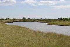
Lion Creek and Lower Raypits is a 65.2 hectare nature reserve east of Canewdon in Essex. It is part of the Crouch and Roach Estuaries Site of Special Scientific Interest,[1][2] and is owned and managed by the Essex Wildlife Trust.[3]
The former creek has been cut off from the Crouch Estuary by a seawall, and it has salt marsh plants such as golden samphire and sea-spurrey. There is a bird hide from which many species of sea birds can be seen. Lower Raypits can be accessed from Lion Creek by the seawall path. It has a variety of pasture, salt marsh and intertidal habitats, with nationally scarce plants such as beaked tasselweed, sea barley, grass vetchling and curved hard-grass. Invertebrates include Roesel's bush-cricket.[3]
There is access from the road between Canewdon and Wallasea Island.[3]
References
- ↑ "Crouch and Roach estuaries citation" (PDF). Sites of Special Scientific Interest. Natural England. Retrieved 12 December 2015.
- ↑ "Map of The Cliff, Burnham-on-Crouch". Sites of Special Scientific Interest. Natural England. Retrieved 4 November 2016.
- 1 2 3 "Lion Creek and Lower Raypits". Essex Wildlife Trust. Retrieved 4 November 2016.
| Wikimedia Commons has media related to Lion Creek and Lower Raypits. |
Coordinates: 51°37′08″N 0°46′34″E / 51.619°N 0.776°E