Lincoln, New Hampshire
| Lincoln, New Hampshire | ||
|---|---|---|
| Town | ||
|
Main Street (NH Route 112) | ||
| ||
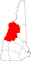
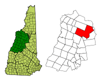 Location in Grafton County, New Hampshire | ||
| Coordinates: 44°02′42″N 71°40′14″W / 44.04500°N 71.67056°WCoordinates: 44°02′42″N 71°40′14″W / 44.04500°N 71.67056°W | ||
| Country | United States | |
| State | New Hampshire | |
| County | Grafton | |
| Incorporated | 1764 | |
| Government | ||
| • Board of Selectmen |
O.J. Robinson, Chair Tamra Ham Jayne Ludwig | |
| • Town Manager | Alfred "Butch" Burbank | |
| Area | ||
| • Total | 130.9 sq mi (339.0 km2) | |
| • Land | 130.3 sq mi (337.6 km2) | |
| • Water | 0.6 sq mi (1.5 km2) 0.43% | |
| Elevation | 811 ft (247 m) | |
| Population (2010) | ||
| • Total | 1,662 | |
| • Density | 13/sq mi (4.9/km2) | |
| Time zone | Eastern (UTC-5) | |
| • Summer (DST) | Eastern (UTC-4) | |
| ZIP code | 03251 | |
| Area code(s) | 603 | |
| FIPS code | 33-41860 | |
| GNIS feature ID | 0873646 | |
| Website |
www | |

Lincoln is a town in Grafton County, New Hampshire, United States. It is the second-largest town by area in New Hampshire. The population was 1,662 at the 2010 census.[1] The town is home to the New Hampshire Highland Games and to a portion of Franconia Notch State Park. Set in the White Mountains, large portions of the town are within the White Mountain National Forest. The Appalachian Trail crosses in the northeast. Lincoln is the location of the Loon Mountain ski resort and associated recreation-centered development.
The primary settlement in town, where 993 people resided at the 2010 census,[1] is defined as the Lincoln census-designated place (CDP) and is located along New Hampshire Route 112 east of Interstate 93. The town also includes the village of North Lincoln and the former village sites of Stillwater and Zealand (sometime known as Pullman) in the town's remote eastern and northern sections respectively, which are now within the White Mountain National Forest.
History

In 1764, Colonial Governor Benning Wentworth granted 32,456 acres (131.34 km2) to a group of approximately 70 land investors from Connecticut. Lincoln was named after Henry Fiennes Pelham-Clinton, 2nd Duke of Newcastle, 9th Earl of Lincoln – a cousin of the Wentworth governors. He held the position of comptroller of customs for the port of London under George II and George III, which was important to trade between America and England.[2]
The town was settled about 1782. The 1790 census indicates that it had 22 inhabitants. Rocky soil yielded poor farming, but the area's abundant timber, combined with water power to run sawmills on the Pemigewasset River and its East Branch, helped Lincoln develop into a center for logging. By 1853, the Merrimack River Lumber Company was operating. The railroad transported freight, and increasingly brought tourists to the beautiful mountain region. In 1892, James E. Henry bought approximately 100,000 acres (400 km2) of virgin timber and established a logging enterprise at what is today the center of Lincoln. In 1902, he built a pulp and paper mill. He erected The Lincoln House hotel in 1903, although a 1907 fire would nearly raze the community. Until he died in 1912, Henry controlled his company town, installing relatives in positions of civic authority.[3]
In 1917, Henry's heirs sold the business to the Parker Young Company, which in turn sold it to the Marcalus Manufacturing Company in 1946. Franconia Paper took over in 1950, producing 150 tons of paper a day until bankruptcy in 1971, at which time new river classification standards discouraged further papermaking in Lincoln.[3]
Tourism is today the principal business. Nearby Loon Mountain has long drawn skiers, and in recent years has attempted to convert itself into a four-season attraction. The Flume is one of the most visited attractions in the state. Discovered in 1808, it is a natural canyon extending 800 feet (240 m) at the base of Mount Liberty. Walls of Conway granite rise to a height of 70 to 90 feet (21 to 27 m) and are only 12 to 20 feet (2.5 to 6.0 m) apart.
Geography
According to the United States Census Bureau, the town has a total area of 130.9 square miles (339.0 km2), of which 130.3 square miles (337.5 km2) is land and 0.6 square miles (1.6 km2) is water, comprising 0.43% of the town.[4] It is the second-largest town in area in New Hampshire, after Pittsburg.
Lincoln is drained by the Pemigewasset River and its East Branch. Lincoln lies almost fully within the Merrimack River watershed, with the western edge of town in the Connecticut River watershed.[5] Kancamagus Pass, elevation 2,860 feet (870 m), is on the Kancamagus Highway at the eastern boundary. The highest point in Lincoln is either the summit of Mount Carrigain, at 4,700 ft (1,433 m) above sea level, plus or minus 10 ft (3.0 m), or the summit of Mount Bond at 4,698 ft (1,432 m).
Demographics
| Historical population | |||
|---|---|---|---|
| Census | Pop. | %± | |
| 1790 | 22 | — | |
| 1800 | 41 | 86.4% | |
| 1810 | 100 | 143.9% | |
| 1820 | 32 | −68.0% | |
| 1830 | 50 | 56.3% | |
| 1840 | 76 | 52.0% | |
| 1850 | 57 | −25.0% | |
| 1860 | 71 | 24.6% | |
| 1870 | 71 | 0.0% | |
| 1880 | 65 | −8.5% | |
| 1890 | 110 | 69.2% | |
| 1900 | 541 | 391.8% | |
| 1910 | 1,278 | 136.2% | |
| 1920 | 1,473 | 15.3% | |
| 1930 | 1,548 | 5.1% | |
| 1940 | 1,560 | 0.8% | |
| 1950 | 1,415 | −9.3% | |
| 1960 | 1,228 | −13.2% | |
| 1970 | 1,341 | 9.2% | |
| 1980 | 1,313 | −2.1% | |
| 1990 | 1,229 | −6.4% | |
| 2000 | 1,271 | 3.4% | |
| 2010 | 1,662 | 30.8% | |
| Est. 2015 | 1,711 | [6] | 2.9% |


As of the census[8] of 2000, there were 1,271 people, 583 households, and 324 families residing in the town. The population density was 9.7 people per square mile (3.8/km²). There were 2,339 housing units at an average density of 17.9 per square mile (6.9/km²). The racial makeup of the town was 97.40% White, 0.39% Native American, 0.87% Asian, 0.16% from other races, and 1.18% from two or more races. 0.71% of the population were Hispanic or Latino of any race.
There were 583 households out of which 22.8% had children under the age of 18 living with them, 43.4% were married couples living together, 8.9% had a female householder with no husband present, and 44.4% were non-families. 35.7% of all households were made up of individuals and 12.7% had someone living alone who was 65 years of age or older. The average household size was 2.18 and the average family size was 2.83.
In the town the population was spread out with 19.8% under the age of 18, 7.1% from 18 to 24, 27.9% from 25 to 44, 27.9% from 45 to 64, and 17.4% who were 65 years of age or older. The median age was 43 years. For every 100 females there were 99.2 males. For every 100 females age 18 and over, there were 96.7 males.
The median income for a household in the town was $28,523, and the median income for a family was $44,063. Males had a median income of $25,263 versus $22,784 for females. The per capita income for the town was $17,999. About 3.4% of families and 8.0% of the population were below the poverty line, including 5.3% of those under age 18 and 5.5% of those age 65 or over.
See also
Sites of interest
- Clark's Trading Post
- Franconia Notch State Park, including:
- Hobo Railroad
- Loon Mountain ski resort
- Whale's Tale Water Park
References
- 1 2 United States Census Bureau, American FactFinder, 2010 Census figures. Retrieved March 23, 2011.
- ↑ Coolidge, Austin J.; John B. Mansfield (1859). A History and Description of New England. Boston, Massachusetts. pp. 553–555.
- 1 2 History of Lincoln, New Hampshire
- ↑ "Geographic Identifiers: 2010 Demographic Profile Data (G001) - Lincoln town, New Hampshire". U.S. Census Bureau American Factfinder. Retrieved November 10, 2011.
- ↑ Foster, Debra H.; Batorfalvy, Tatianna N.; Medalie, Laura (1995). Water Use in New Hampshire: An Activities Guide for Teachers. U.S. Department of the Interior and U.S. Geological Survey.
- ↑ "Annual Estimates of the Resident Population for Incorporated Places: April 1, 2010 to July 1, 2015". Retrieved July 2, 2016.
- ↑ "Census of Population and Housing". Census.gov. Retrieved June 4, 2016.
- ↑ "American FactFinder". United States Census Bureau. Retrieved 2008-01-31.
External links
| Wikivoyage has a travel guide for Lincoln, New Hampshire. |
- Official website
- Lincoln Public Library
- New Hampshire Highland Games
- White Mountain Snowmobile Club
- New Hampshire Economic and Labor Market Information Bureau Profile