Limes Moesiae
Limes Moesiae was a Roman-built system of fortifications consisting of three lines of defense, between the Black Sea shore and the Danube. Additionally, in Wallachia there were other two lines of defense: the Constantine Wall and the Limes Transalutanus.
Characteristics
The Limes Moesiae, near the Danube delta, probably was built initially during Trajan times. Between the 2nd and the 3rd century was increased and abandoned.
It seems it was used by non-Roman kingdoms after the 5th/6th century and partially rebuilt and increased[1]
It consists of three sections:
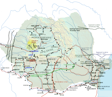
- one in the south between Constanta and the Danube, usually called Trajan's Wall.
- a second just north of the Danube delta, called even Lower Trajan's Wall in Moldova or Athanaric's Wall
- a third in central Moldova from the Prut to the Dniester river, called Upper Trajan's Wall or Greuthungi Wall

These three sections consist of earth ditchs, three meters high and two meters wide, and are very similar to the dykes between Roman Britain and Wales (like Wat's Dyke).
Near the Limes Moesiae there are two other limes related to the defense of Moesia (and Roman Dacia):
- The Constantine Wall, called even Brazda lui Novac de Nord, built in Walachia around 330 A.D. and long 300 km.
- The Limes Transalutanus, probably done by Hadrian to defend Roman Dacia from the southern Carpathian mountains to the Danube.
History
The historian Theodor Mommsen wrote that at the mouth of the Dniester river there was the old Greek city of Tyras, which was "annexed to the province of Moesia" by emperor Nero in 56 AD. There exists a series of its coins with heads of emperors from Domitian to Alexander Severus, showing that Romans were present in this area until the 4th century.
Mommsen even wrote that "Moldavia and the south half of Bessarabia as well as the whole of Wallachia were incorporated in the Roman Empire".
All these facts confirm the creation of defensive earth dykes in order to defend these new territories of the Roman Empire. Furthermore, Mommsen wrote, "Bessarabia is intersected by a double barrier-line which, running from the Pruth to the Dniester, ends at Tyra and appears to proceeds from the Romans".
The Walls, which, tree metres in height and two meters in thickness, with broad outer fosse and many remains of forts, stretch in two almost parallel lines...from the Pruth to the Dniester...may be also Roman.[2]
Full military occupation of the plain between the Carpathian foothills and the Danube may already have occurred by the end of Trajan’s first Dacian War (101/102). The majority of forts here, however, were established after the final conquest of the Dacian kingdom in 106 AD. The abandonment of Moldova and the creation of the Limes Transalutanus fortification-line can both be tentatively dated to the reign of Hadrian. Despite claims to the contrary, the Roman abandonment of Dacia probably occurred during the reign of Gallienus (260-68), before the traditional date of around 275 when Aurelian established the new province of Dacia south of the Danube (Cătăniciu 1981, 53-55).
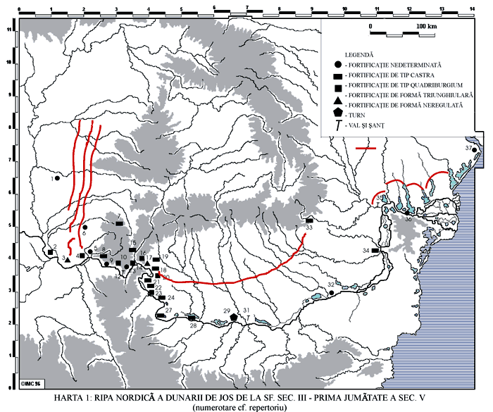
In the Late Roman period, the extent of control and military occupation over territory north of the Danube remains controversial. One Roman fort (Pietroasa de Jos), well beyond the Danubian Limes and near actual Moldavia, would seem to have been occupied in the 4th century AD, as were bridge-head forts (Sucidava,[3] Barboşi, and the unlocated Constantiniana Daphne) along the left bank of the river. In this Roman fort, built by Constantine I, researchers have found even a thermae building in the 1980s.[4]
But the earth bank and ditch, known as the "Brazda lui Novac de Nord" (or "Constantine Wall"), though later than the Limes Transalutanus and often regarded as being of Late Roman date, remained problematic until recent excavatrions indicated without doubt it was done by emperor Constantine around 330 AD.[5] Constantine made this Wall in Wallachia at the same time of the "Devil's Dykes" (or "Limes Sarmatiae"), a series of defensive earthen ramparts-and-ditches, built by the Romans between Romania and the Pannonian plains.[6]
Similarly, although considered 1st century and believed to predate the Limes Transalutanus, the function and origins of a shorter section of bank and ditch known as the "Brazda lui Novac de Sud" remain uncertain. The absence of any evidence for Late Roman forts or settlements along its course and south of it rather suggests a later, probably medieval, date.
The fortification line erected by the king of the Thervings Athanaric, between the banks of river Gerasius (modern Prut) and the Danube to the land of Taifali (modern Oltenia), probably reused the old Roman limes called Limes Transalutanus[7]
Controversy

There is a controversy over the historical perspective of who built the earth dykes: the Romans, the Byzantines or others:
- Roman explanation: Emperor Nero extended the Roman Moesia province north of the Danube delta in 56 AD until Tyras (near actual Odessa), according to Mommsen and this is historically confirmed. With Emperor Trajan they connected the conquered Dacia with the mouth of the Dniester river and probably did the first construction of the earth dyke that later was called Greuthungi Wall. With emperor Hadrian came the consolidation of the Roman territories and the limes was withdrawn to the "Limes Transalutanus" and the smallest "Trajan Wall" between Constanta and the Danube: these two Walls are confirmed to be Romans. When the Roman Empire expanded again after the loss of Roman Dacia, Emperor Constantine made the "Constantine Wall" as a Limes (occupying all Wallachia south of the southern Carpathians mountains) until the earth dyke later called "Antharic Wall". Has been demonstrated by academics [8] that the "Constantine Wall" was built by the Romans around 330 AD and was increased many times until Emperor Justinian in the 6th century.
- Byzantine possibility: Probably the Eastern Roman Empire built or enlarged the two sections of the Limes Moesiae north on the Danube delta, between the 6th and the 10th centuries. They wanted to defend the Greek colonies in the Black Sea coast (between the Danube and Crimea) from the continuous barbarian invasions.
- There it is even another theory: the Barbarian. This hypothesizes a Trajan's Wall, not related to the Roman Empire. This Trajan's Wall should be connected to the Serpent's Wall, made by Barbarian Kingdoms, that stretched from Bucovina to central Ukraine. This theory [9] supports the opinion that the "Athanaric Wall" and the "Greuthungi Wall" are not Roman, creating a controversy.
Notes
- ↑ Romans in eastern Romania (in Romanian)
- ↑ Theodor Mommsen. The Provinces of the Roman Empire. p. 226
- ↑ Sucidava photos
- ↑ Archeological research about Romans in Romania during the 3rd and 4th centuries (in Romanian)
- ↑ Wacher. The Roman world p.189
- ↑ Map showing the Roman fortifications in the 4th century
- ↑ The Goths By Peter Heather page 100
- ↑ J. S. Wacher. The Roman world p.190
- ↑ Heather, Peter. The Goths p. 100
Bibliography
- András Mócsy. Pannonia and Upper Moesia. Penguin Ed. London, 1974.
- Heather, Peter. The Goths. Blackwell ed. Malden, 1998.
- Mommsen, Theodore. The Provinces of the Roman Empire. Barnes & Noble Books. New York, 1996 ISBN 0-7607-0145-8
- Wacher, J.S. The Roman world. Routledge Publisher. New York, 2002. ISBN 0-415-26314-X