Limanköy, Çayeli
| Limanköy, Çayeli | |
|---|---|
| Town | |
 | |
 Location of Limanköy, Çayeli within Turkey. | |
| Coordinates: 41°04′N 40°41′E / 41.067°N 40.683°ECoordinates: 41°04′N 40°41′E / 41.067°N 40.683°E | |
| Country |
|
| Region | Black Sea |
| Province | Rize |
| Area | |
| • Total | 4 km2 (2 sq mi) |
| Time zone | EET (UTC+2) |
| • Summer (DST) | EEST (UTC+3) |
| Postal code | 53 |
| Area code(s) | (0090)+ 464 532 |
| Licence plate | 53 |
| Website | http://www.limankoy.net |
Limanköy is a township in Çayeli district of Rize province on the Black Sea coast of eastern Turkey, 6 km west of the town of Çayeli. Limanköy is in the east of Büyük Caferpaşa, in the south of Demirhisar and Akpınar.It is the largest neighborhood in Çayeli.[1]
Infrastructure
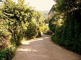
There are two boathouses and a harbor, two swimming areas and a beach. There are concrete and asphalt roads also stabilized roads. Next to the coast highway is 2,5 km (1,5mil). Most of the way out of it is concrete. In Limanköy, there are lots of natural water sources also there are water sources of government. Most people use natural water which came to from mounts. In Limanköy, there are three mosques; Hamuda, Merkez and Darlık Mosques. One of them is in entrance of Limanköy, others of them is in another parts of Limanköy.
Etymology
Limanköy was formerly known as Artotil[2] in Ottoman Empire. Now, The name is Limanköy. Mean of Limanköy is Liman-Koy
| Turkish | Ottoman Turkish | English |
|---|---|---|
| Liman | ليمان | (the) Port |
| Koy | كوي | bay (geography) |
Geography
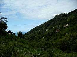
Limanköy consists of a narrow coastal strip and a large section of the Black Sea Mountain range which rises steeply and runs parallel to the coast. There are green hills. At 420m, Hill Jandarma (Jandarmağun Tepe) is the highest point.
However, for anyone who does venture up here the countryside is unspoilt forest and the views from these steep mountainsides are incredible; therefore Limanköy is now attracting visitors on trekking holidays.
History
Mapavri was since long inhabited by the Laz community, and was part of the Roman Empire and then the Empire of Trebizond until was brought within the Ottoman Empire by Mehmet II in 1461, although this coast has always been vulnerable to invaders from across the nearby Caucasus.
In the recent past Limanköy was an impoverished remote region that saw successive generations migrate away to jobs in Turkey's larger cities or abroad. This emigration slowed when tea was planted here in the 1940s.
Community
The local economy is mainly dependent on tea-growing. Also, people will grow corn and kiwi. People deal with the free professions because most of the People who stay in Limanköy are pensioners. Young people often comes in here for holiday.
Limanköy is famous for Atmaca means hawk. In summer, people usually feed on huwk and hunt bird with hawk. This was more common in the past.
The literacy rate is very high. After the Republic literacy is 100%. There are a lot of member of parliaments and businessmen.

Activities
The Bike Competition of Limanköy[3] (Limanköy Uluslararası Bisiklet Yarışı)
This activity going to start 2010 or 2011. The project has not completed yet.
- Trail distance: 15,52 kilometers
- Elevation min: 2 meters, max: 517 meters
- Accum. height uphill: 1.260 meters, downhill: 1.251 meters
- Difficulty level: skill Difficult
- Ends at start point (loop): No
- Coordinates: 471
References
- ↑ http://www.limankoy.net/liman/Html/muhtar.htm
- ↑ http://www.cayeli.org.tr/koyler.php?id=12&page=10
- ↑ http://www.cayeli.org.tr/forum/index.php?topic=2341.msg9501#msg9501
External links
| Wikimedia Commons has media related to Çayeli. |
- (Turkish) the Web site
- (English) the Information of Limanköy
- (Turkish) the Information of Limanköy
- (Turkish) CNN News(1)
- (Turkish) CNN News(2)
- (Turkish) (English) Facebook Advertisement Page of the Limanköy
- (English) Google Earth Community - Google Earth KMZ File of Limanköy
