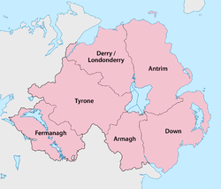
Counties of Northern Ireland
| Counties of Northern Ireland | |
|---|---|
 | |
| Category | Administrative unit |
| Location | Northern Ireland |
| Number | Six |
| Populations | 61,170 (Fermanagh) – 618,108 (Antrim) |
| Areas | 1,176 square miles (3,050 km2) (Armagh) - 3,263 square miles (8,450 km2) (Tyrone) |
| Government | County government |
| Subdivisions | Cities, Towns, Villages, Townlands, Landforms, Baronies |
The counties of Northern Ireland were the principal local government divisions of Northern Ireland from its creation in 1921 until 1972, when their governmental features were abolished and replaced with twenty-six unitary authorities.[1]
In total Northern Ireland consisted of six counties: Antrim, Armagh, Down, Fermanagh, Londonderry (also known as Derry) and Tyrone. These form two-thirds of the historical province of Ulster. The number has been used in the designation The Six Counties as an Irish-nationalist alternative name for Northern Ireland.
The counties
| County | County town | First created[2] | Population (2011) | Notes |
|---|---|---|---|---|
| Antrim | Antrim | Early 14th century | 618,108 | Modern boundaries formed in 1605.[2] |
| Armagh | Armagh | 1584 | 174,792 | |
| Down | Downpatrick | Early 14th century | 531,665 | Modern boundaries formed in 1605.[2] |
| Fermanagh | Enniskillen | 1584 | 61,170 | Based on the territory of the Maguires. |
| Londonderry | Coleraine | 1613 | 247,132 | Merging of County Coleraine (also spelt as Colerain[3][4]), and the baronies of Loughinsholin, North East Liberties of Coleraine, and the North-West Liberties of Londonderry. |
| Tyrone | Omagh | 1584 | 177,986 | Based on the Irish kingdom of Tír Eoghain, with its north-eastern part (barony of Loughinsholin) being merged with County Londonderry in 1613. |
Background of the counties
The English administration in Ireland in the years following the Anglo-Norman invasion of Ireland created counties as the major subdivisions of an Irish province.[2] This process lasted a period from the 13th to 17th centuries, however the number and shape of the counties that would form the future Northern Ireland would not be defined until the Flight of the Earls allowed the shiring of Ulster from 1604.[1]
Though the present-day counties of Northern Ireland were planned in the early 16th century, some had already existed in one form or another beforehand although their boundaries would be adjusted.[2] Each county would have an associated county town, with county courts of Quarter Sessions and Assizes.[2]
Origins
The counties of Antrim and Down have their origins in the Norman Earldom of Ulster which was based on John de Courcy's conquest of Ulaid.[5] Between the late 13th and early 14th centuries it was organised into administrative shires based around centres of Norman power such as Antrim, Carrickfergus, and Newtownards.[5]
The Bruce invasion (1315–18) saw the devastation of the Earldom of Ulster and its overlordship over the neighbouring Gaelic districts. With the murder of the last de Burgh earl in 1333, the resulting Gaelic recovery eroded the earldoms territory until by the 15th century only the areas of Carrickfergus and coastal enclaves in Down remained.[5]
It was not until the reign of Queen Elizabeth I that Ulster would be shired into more counties, based largely on the boundaries of existing lordships. In 1584, Lord Deputy of Ireland Sir John Perrott created the following counties in what is now Northern Ireland: Armagh; Coleraine; Fermanagh; and Tyrone. Carrickfergus would retain its status as a county town until 1777 when it was merged with County Antrim.
| Development of Northern Ireland's counties | ||||||||
|---|---|---|---|---|---|---|---|---|
|
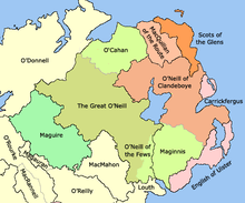


Baronies
Each county was divided into a number of baronies, a midway between a county and a parish. Baronies are now obsolete administrative units, partially derived from the territory of an Irish chieftain. By the time the process of turning local Irish kingdoms into baronies occurred throughout the whole of Ulster by the early 17th century as part of the Plantation of Ulster, it was already being used for taxation and administrative purposes.[2]
Baronies were used for many records from the 17th to 19th centuries such as: the Civil Survey; Petty's Down Survey; the Books of Survey and Distribution; the 19th century valuation books and census returns. The Grand Jury representment system would also be based on the barony.[2]
Government and modern usage
The counties were also used as the administrative unit of local government introduced in Ireland under the 1898 Local Government Act along with county boroughs. In regards to Northern Ireland the cities of Belfast and Londonderry became county boroughs. The counties and county boroughs in terms of governance where abolished in Northern Ireland in 1972 and replaced with twenty-six unitary councils, many of which cross county boundaries.
The six administrative counties and two county boroughs remain in use for some purposes, including car number plates. The six counties were also used as postal counties by the Royal Mail for sorting purposes until their abolition in 1996. Outside government, the counties are sometimes used for cultural purposes, for example in the Gaelic Athletic Association.
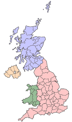
Lieutenancy areas
Like the rest of the United Kingdom, Northern Ireland is divided into lieutenancy areas (see map on right). These are areas that have an appointed Lord Lieutenant—the representative of the British monarch. Northern Ireland has eight lieutenancy areas: Antrim, Armagh, Down, Fermanagh, Tyrone, County of Londonderry, City of Londonderry, and City of Belfast. These are contiguous with the former six counties and two county boroughs, established by the 1898 Local Government Act.
Former counties
Former counties which formed part of the six modern counties of Northern Ireland:
- County Coleraine formed from the territory of the O'Cahans in 1584 by Queen Elizabeth I, formed the basis of modern County Londonderry.
- Carrickfergus was formerly a county of itself, it extended further than the modern borough of Carrickfergus. It was merged into County Antrim in 1777.
- Antrim, Blathewyc, Cragferus, Coulrath, del Art, Dun, Ladcathel and Twescard, the seven counties that formed the Earldom of Ulster in 1333.[6][7]
- In 1549, Ulster itself was called a county containing the baronies of Arde, Bentry, Dondalk, Dufferens, Gallagh, Grenecastle, Kroghfergous, Lacayall, Maulyn, Twscard, and Glyns.[7]
See also
- Local government in Northern Ireland
- Counties of the United Kingdom
- Counties of Ireland
- List of Irish counties by population
- List of Irish counties by area
- Provinces of Ireland
References
- 1 2 Connolly, J.S.: Oxford Companion to Irish History, page 129. Oxford University Press, 2002. ISBN 978-0-19-923483-7
- 1 2 3 4 5 6 7 8 Public Records Office of Northern Ireland – Areas, regions, and land divisions
- ↑ LibraryIreland – Principal Families of Ulster: In Tirowen, section (c) The modern nobility in Tir Owen
- ↑ Google Books – The Fall of Irish Chiefs and Clans; The Conquest of Ireland, by George Hill
- 1 2 3 Connolly, J.S.: Oxford Companion to Irish History, page 589-590. Oxford University Press, 2002. ISBN 978-0-19-923483-7
- ↑ Bardon, Jonathan: A History of Ulster, page 45. The Black Staff Press, 2005. ISBN 0-85640-764-X
- 1 2 Hughes and Hannan: Place-Names of Northern Ireland, Volume Two, County Down II, The Ards, The Queen's University of Belfast, 1992. ISBN 085389-450-7
External links
| Wikimedia Commons has media related to Counties of Northern Ireland. |
| ||||||||||||||||||||||||||||||||||||||||||||||||||||||||
