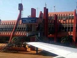
Libertador General José de San Martín Airport
| Libertador General José de San Martín Airport Aeropuerto de Posadas "Libertador General San Martín" | |||||||||||
|---|---|---|---|---|---|---|---|---|---|---|---|
 | |||||||||||
| IATA: PSS – ICAO: SARP | |||||||||||
| Summary | |||||||||||
| Airport type | Public / Military | ||||||||||
| Operator | Aeropuertos Argentina 2000 | ||||||||||
| Serves | Posadas, Misiones Province, Argentina | ||||||||||
| Location | Ruta N12, Km 1336, Posadas (N3300) | ||||||||||
| Elevation AMSL | 430 ft / 131 m | ||||||||||
| Coordinates | 27°23′09″S 55°58′14″W / 27.38583°S 55.97056°WCoordinates: 27°23′09″S 55°58′14″W / 27.38583°S 55.97056°W | ||||||||||
| Map | |||||||||||
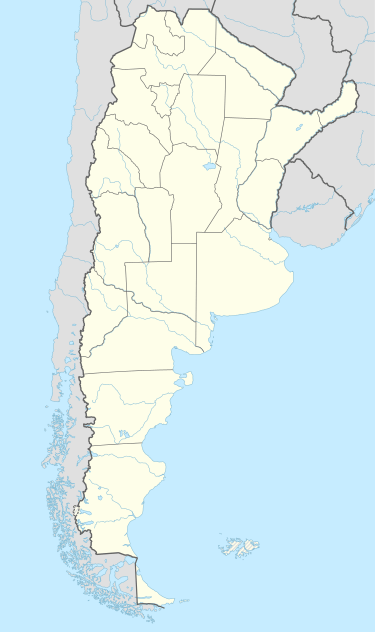 PSS Location of airport in Argentina | |||||||||||
| Runways | |||||||||||
| |||||||||||
| Statistics (2010) | |||||||||||
| |||||||||||
Libertador General José de San Martín Airport (Spanish: Aeropuerto de Posadas "Libertador General San Martín") (IATA: PSS, ICAO: SARP) is located 7.5 km (4.7 mi) northwest of the center of Posadas, a city in the Misiones Province of Argentina. The airport covers an area of 329 hectares (813 acres) and is operated by Aeropuertos Argentina 2000 S.A.[1][2]
It has a 6,500 m² terminal, 67,740 m² of runways, and parking spaces for 100 vehicles. In 2007, it handled 65,019 passengers. At its peak in 1997, it handled 164,586 passengers.
Airlines and destinations
| Airlines | Destinations |
|---|---|
| Aerolíneas Argentinas | Buenos Aires-Aeroparque |
| Aerolíneas Argentinas Operated by Austral Líneas Aéreas | Buenos Aires-Aeroparque |
Statistics
| Passengers | Change from previous year | Aircraft operations | Change from previous year | Cargo (metric tons) | Change from previous year | |
|---|---|---|---|---|---|---|
| 2005 | 101,787 | | 2,933 | | 564 | |
| 2006 | 92,741 | | 3,099 | | 455 | |
| 2007 | 65,019 | | 2,503 | | 313 | |
| 2008 | 56,144 | | 2,623 | | 210 | |
| 2009 | 100,393 | | 3,177 | | 345 | |
| 2010 | 99,538 | | 3,711 | | 379 | |
| Source: Airports Council International. World Airport Traffic Statistics (Years 2005-2010) | ||||||
Accidents and incidents
On June 12, 1988, Austral Lineas Aereas Flight 46 undershot the runway, resulting in 22 deaths.
On October 10, 1997, Austral Flight 2553 left the airport for Buenos Aires but crashed one hour later in Fray Bentos, Uruguay, killing 75 (all crew and passengers). This was the worst aviation accident to take place in Uruguay.
References
- 1 2 (Spanish) "SARP - Posadas / Libertador Gral. D. José de San Martín" (PDF). at AIP Argentina
- 1 2 (Spanish) Aeropuerto de Posadas "Libertador General San Martín" at Organismo Regulador del Sistema Nacional de Aeropuertos (ORSNA)
- ↑ Airport information for SARP at World Aero Data. Data current as of October 2006.Source: DAFIF.
- ↑ Airport information for PSS at Great Circle Mapper. Source: DAFIF (effective October 2006).
- ↑ Airport Council International 2010 World Airport Traffic Report
External links
- Posadas, PSS at Aeropuertos Argentina 2000 (official web site)
- Current weather for SARP at NOAA/NWS
- Accident history for PSS at Aviation Safety Network