Levisa Fork
| Levisa Fork | |
| River | |
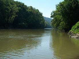 The Levisa Fork in Paintsville | |
| Country | United States |
|---|---|
| States | Kentucky, Virginia |
| Counties | Buchanan VA, Pike KY, Floyd KY, Johnson KY, Lawrence KY |
| Source | Gap of Sandy [1] |
| - location | Buchanan County, VA |
| - elevation | 2,657 ft (810 m) [2] |
| - coordinates | 37°09′06″N 81°54′04″W / 37.15167°N 81.90111°W |
| Mouth | Big Sandy River [1] |
| - location | Louisa, KY |
| - elevation | 545 ft (166 m) |
| - coordinates | 38°07′05″N 82°36′06″W / 38.11806°N 82.60167°WCoordinates: 38°07′05″N 82°36′06″W / 38.11806°N 82.60167°W |
| Length | 164 mi (264 km) [3] |
| Discharge | for Pikeville, KY |
| - average | 1,504 cu ft/s (43 m3/s) [4] |
| - max | 85,500 cu ft/s (2,421 m3/s) |
| - min | 66 cu ft/s (2 m3/s) |
 Map of the Big Sandy River watershed, with its Levisa Fork (left) and Tug Fork (right) tributaries shown | |
The Levisa Fork (also known as the Levisa Fork River or the Levisa Fork of the Big Sandy River) is a tributary of the Big Sandy River, approximately 164 miles (264 km) long,[3] in southwestern Virginia and eastern Kentucky in the United States.
Overview

It rises in the Appalachian Mountains of southwestern Virginia, in eastern Buchanan County, near Grundy. It flows west into Pike County, Kentucky, where it receives the Russell Fork and is impounded to form Fishtrap Lake reservoir, then northwest past Pikeville and Prestonsburg. The natural course of the river formed a loop surrounding downtown Pikeville, but a massive earthmoving project completed in 1987 rerouted the river to bypass the city. At Paintsville it turns to the north-northeast, flowing through Johnson and Lawrence counties. It joins the Tug Fork from the southwest at Louisa on the West Virginia state line to form the Big Sandy.
The Levisa Fork was historically an important river for log driving.[5] The river is partly navigable for commercial purposes through a series of locks. In the early 1900s the river was navigable as far as Pikeville.
Variant names, according to the USGS, include Louisa River, Louisa Fork, Lavisa Fork, and West Fork, in addition to Levisa Fork River and Levisa Fork of the Big Sandy River. The official name according to the USGS is Levisa Fork.[1] According to Robert F. Collins of the United States Forest Service, 18th-century explorer Dr. Thomas Walker had named the nearby Kentucky River the Louisa River, after Princess Louisa, sister of Prince William Augustus, Duke of Cumberland (Walker had just named the Cumberland River a month or two earlier). According to George R. Stewart, frontiersmen "forgot" who it was named for and it changed over time to Levisa.
On February 28, 1958, a Floyd County school bus tumbled into the Levisa Fork after a collision with a wrecker truck, leading to one of the worst bus disasters in American history.
See also
References
- 1 2 3 "Levisa Fork". Geographic Names Information System. United States Geological Survey. 1979-09-20. Retrieved 2009-07-18.
- ↑ "Levisa Fork Source". Elevation Query. U.S. Geological Survey. Retrieved 2009-07-18.
- 1 2 U.S. Geological Survey. National Hydrography Dataset high-resolution flowline data. The National Map, accessed June 13, 2011
- ↑ United States Geological Survey; USGS 03209500 LEVISA FORK AT PIKEVILLE, KY; retrieved July 18, 2009.
- ↑ Federal Writers' Project (1996). The WPA Guide to Kentucky. University Press of Kentucky. p. 241. Retrieved 24 November 2013.
- Stewart, George R. "Names on the Land". (1967)
- Collins, Robert F. "A History of the Daniel Boone National Forest". (1975)