Leslie Gap
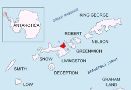

Leslie Gap (Sedlovina Leslie \se-dlo-vi-'na 'les-li\) is an 359m high ice-covered saddle extending 2.8 km in south-north direction between Leslie Hill and Radnevo Peak on Varna Peninsula in northeastern Livingston Island in the South Shetland Islands, Antarctica. The saddle separates the glacial catchments of Kaliakra Glacier to the east and Saedinenie Snowfield to the west. It is part of the overland route from Bowles Ridge to Vidin Heights. The south extremity of the saddle features a minor but conspicuous ice-covered knoll of elevation 404 m just north of Leslie Hill. Leslie Gap takes its name from the adjacent Leslie Hill and was first trekked by the Bulgarian Lyubomir Ivanov from Camp Academia on 25 December 2004.
Location
The gap is centred at 62°33′20″S 60°11′50″W / 62.55556°S 60.19722°WCoordinates: 62°33′20″S 60°11′50″W / 62.55556°S 60.19722°W which is 2.16 km north-northeast of the midpoint of Elhovo Gap, 6.1 km north of Omurtag Pass and 1.29 km southwest of Miziya Peak (British mapping in 1968, rough Argentine mapping in 1980, and Bulgarian mapping in 2005 and 2009 from the topographic survey Tangra 2004/05).
Maps
- L.L. Ivanov et al. Antarctica: Livingston Island and Greenwich Island, South Shetland Islands. Scale 1:100000 topographic map. Sofia: Antarctic Place-names Commission of Bulgaria, 2005.
- L.L. Ivanov. Antarctica: Livingston Island and Greenwich, Robert, Snow and Smith Islands. Scale 1:120000 topographic map. Troyan: Manfred Wörner Foundation, 2009.
References
This article includes information from the Antarctic Place-names Commission of Bulgaria which is used with permission.