Lescure, Ariège
| Lescure | ||
|---|---|---|
|
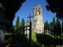
The 12th Century church of Noguès | ||
| ||
 Lescure | ||
|
Location within Occitanie region  Lescure | ||
| Coordinates: 43°00′05″N 1°14′03″E / 43.0014°N 1.2342°ECoordinates: 43°00′05″N 1°14′03″E / 43.0014°N 1.2342°E | ||
| Country | France | |
| Region | Occitanie | |
| Department | Ariège | |
| Arrondissement | Saint-Girons | |
| Canton | Saint-Girons | |
| Intercommunality | Val-Couserans | |
| Government | ||
| • Mayor (2008–2014) | Jean-Marie Monreysse | |
| Area1 | 25.8 km2 (10.0 sq mi) | |
| Population (2008)2 | 503 | |
| • Density | 19/km2 (50/sq mi) | |
| Time zone | CET (UTC+1) | |
| • Summer (DST) | CEST (UTC+2) | |
| INSEE/Postal code | 09164 / 09420 | |
| Elevation |
410–820 m (1,350–2,690 ft) (avg. 493 m or 1,617 ft) | |
|
1 French Land Register data, which excludes lakes, ponds, glaciers > 1 km² (0.386 sq mi or 247 acres) and river estuaries. 2 Population without double counting: residents of multiple communes (e.g., students and military personnel) only counted once. | ||
.svg.png)
Lescure is a commune in the Ariège department in southwestern France.
Population
| Historical population | ||
|---|---|---|
| Year | Pop. | ±% |
| 1962 | 390 | — |
| 1968 | 451 | +15.6% |
| 1975 | 387 | −14.2% |
| 1982 | 385 | −0.5% |
| 1990 | 388 | +0.8% |
| 1999 | 461 | +18.8% |
| 2008 | 503 | +9.1% |
See also
References
| Wikimedia Commons has media related to Lescure. |
This article is issued from Wikipedia - version of the 7/20/2016. The text is available under the Creative Commons Attribution/Share Alike but additional terms may apply for the media files.