Les Authieux-Papion
| Les Authieux-Papion | |
|---|---|
 | |
 Les Authieux-Papion | |
|
Location within Normandy region  Les Authieux-Papion | |
| Coordinates: 49°03′57″N 0°03′14″E / 49.0658°N 0.0539°ECoordinates: 49°03′57″N 0°03′14″E / 49.0658°N 0.0539°E | |
| Country | France |
| Region | Normandy |
| Department | Calvados |
| Arrondissement | Lisieux |
| Canton | Mézidon-Canon |
| Intercommunality | Vallée d'Auge |
| Government | |
| • Mayor (1979–2020) | Jean-Pierre Perthuis |
| Area1 | 4.28 km2 (1.65 sq mi) |
| Population (2010)2 | 62 |
| • Density | 14/km2 (38/sq mi) |
| Time zone | CET (UTC+1) |
| • Summer (DST) | CEST (UTC+2) |
| INSEE/Postal code | 14031 / 14140 |
| Elevation |
30–79 m (98–259 ft) (avg. 59 m or 194 ft) |
|
1 French Land Register data, which excludes lakes, ponds, glaciers > 1 km² (0.386 sq mi or 247 acres) and river estuaries. 2 Population without double counting: residents of multiple communes (e.g., students and military personnel) only counted once. | |
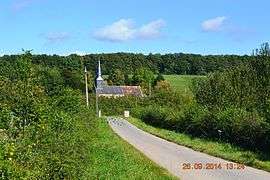
Les Authieux-Papion is a French commune in the Calvados department in the Normandy region of north-western France.
Geography
Les Authieux-Papion is located some 14 km south-west of Lisieux and 11 km north-east of Saint-Pierre-sur-Dives. The D47 road runs along the northern border of the commune from Mézidon-Canon in the west to join the D511 which runs down the eastern border of the commune from Saint-Julien-le-Faucon in the north-east to Saint-Pierre-sur-Dives in the south-west. Access to the village is by local roads off these two roads. There is a large forest towards the south (the Bois des Authieux) and another large forest in the north with the rest of the commune farmland.[1]
The Viette river flows through the centre of the commune from east to west as it flows west then north to join the Vie at Le Mesnil-Mauger.[1]
Neighbouring communes and villages[1]
 |
Le Mesnil-Mauger | Grandchamp-le-Château | Saint-Julien-le-Faucon | |
| Ouville-la-Bien-Tournée | |
Coupesarte | ||
| ||||
| | ||||
| Bretteville-sur-Dives | Vieux-Pont-en-Auge |
Administration
List of Successive Mayors[2]
| From | To | Name | Party | Position |
|---|---|---|---|---|
| 1979 | 2020 | Jean-Pierre Perthuis |
(Not all data is known)
Demography
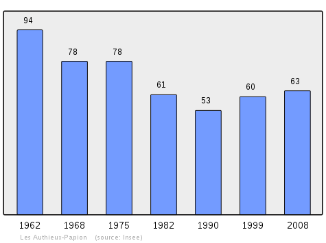
In 2010 the commune had 62 inhabitants. The evolution of the number of inhabitants is known from the population censuses conducted in the commune since 1793. From the 21st century, a census of communes with fewer than 10,000 inhabitants is held every five years, unlike larger communes that have a sample survey every year.[Note 1]
| 1793 | 1800 | 1806 | 1821 | 1831 | 1836 | 1841 | 1846 | 1851 |
|---|---|---|---|---|---|---|---|---|
| 222 | 235 | 203 | 187 | 178 | 182 | 183 | 177 | 161 |
| 1856 | 1861 | 1866 | 1872 | 1876 | 1881 | 1886 | 1891 | 1896 |
|---|---|---|---|---|---|---|---|---|
| 134 | 140 | 133 | 130 | 116 | 145 | 122 | 117 | 102 |
| 1901 | 1906 | 1911 | 1921 | 1926 | 1931 | 1936 | 1946 | 1954 |
|---|---|---|---|---|---|---|---|---|
| 95 | 90 | 95 | 116 | 110 | 88 | 71 | 78 | 116 |
| 1962 | 1968 | 1975 | 1982 | 1990 | 1999 | 2006 | 2010 | - |
|---|---|---|---|---|---|---|---|---|
| 94 | 78 | 78 | 61 | 53 | 60 | 72 | 62 | - |
Sources : Ldh/EHESS/Cassini until 1962, INSEE database from 1968 (population without double counting and municipal population from 2006)
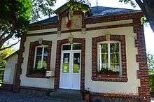

Sites and monuments


In the Parish Church of Saint-Philbert there is a Statue: Virgin and child (15th century)![]() which is registered as an historical object.[3]
which is registered as an historical object.[3]
See also
External links
- Les Authieux-Papion on Lion1906
- Les Authieux-Papion on Google Maps
- Les Authieux-Papion on Géoportail, National Geographic Institute (IGN) website (French)
- les Autieux Papion on the 1750 Cassini Map
- Les Authieux-Papion on the INSEE website (French)
- INSEE (French)
Notes and references
Notes
- ↑ At the beginning of the 21st century, the methods of identification have been modified by Law No. 2002-276 of 27 February 2002, the so-called "law of local democracy" and in particular Title V "census operations" allows, after a transitional period running from 2004 to 2008, the annual publication of the legal population of the different French administrative districts. For communes with a population greater than 10,000 inhabitants, a sample survey is conducted annually, the entire territory of these communes is taken into account at the end of the period of five years. The first "legal population" after 1999 under this new law came into force on 1 January 2009 and was based on the census of 2006.
References
- 1 2 3 Google Maps
- ↑ List of Mayors of France (French)
- ↑ Ministry of Culture, Palissy PM14000029 Statue: Virgin and child
(French)

| Wikimedia Commons has media related to Les Authieux-Papion. |