Lentua
| Lentua | |
|---|---|
 Panorama of beach and island in Lentua. | |
| Location | Kuhmo |
| Coordinates | 64°14′N 029°36′E / 64.233°N 29.600°ECoordinates: 64°14′N 029°36′E / 64.233°N 29.600°E |
| Type | Lake |
| Primary inflows | Isojoki, Iivantiira, Kalliojoki |
| Primary outflows | Lentuankoski |
| Basin countries | Finland |
| Surface area | 77.842 km2 (30.055 sq mi) |
| Average depth | 7.41 m (24.3 ft) |
| Max. depth | 52 m (171 ft) |
| Water volume | 0.582 km3 (472,000 acre·ft) |
| Shore length1 | 271.41 km (168.65 mi) |
| Surface elevation | 167.9 m (551 ft) |
| Frozen | November–May |
| Islands | Kotasaari, Salonsaari |
| References | [1] |
| 1 Shore length is not a well-defined measure. | |
Lentua is a medium-sized lake of Finland and it is the 57th biggest lake in Finland. It belongs to Oulujoki main catchment area and it is situated in Kuhmo municipality in the Kainuu region.[1] There is a route around the lake for paddlers.
 Protected forest and eskers.
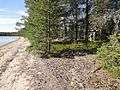 Lagoon-style beach on an island.
 Rocky beach.
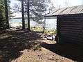 Public cottage on an island.
See also
References
- 1 2 Lentua in the Jarviwiki Web Service. Retrieved 2014-02-27. (English)
External links
-
 Media related to Lake Lentua at Wikimedia Commons
This article is issued from Wikipedia - version of the 9/4/2015. The text is available under the Creative Commons Attribution/Share Alike but additional terms may apply for the media files.