Lens Creek
| Lens Creek | |
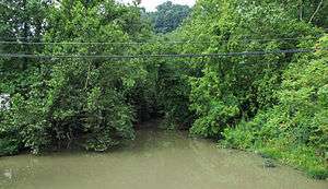 Lens Creek near its mouth in Marmet | |
| Country | United States |
|---|---|
| State | West Virginia |
| County | Kanawha |
| Source | |
| - location | north-northwest of Bloomingrose |
| - elevation | 1,278 ft (390 m) [1] |
| - coordinates | 38°10′54″N 81°38′26″W / 38.1817678°N 81.6406754°W [2] |
| Mouth | Kanawha River |
| - location | Marmet |
| - elevation | 591 ft (180 m) [2] |
| - coordinates | 38°14′26″N 81°33′30″W / 38.2406568°N 81.5584526°WCoordinates: 38°14′26″N 81°33′30″W / 38.2406568°N 81.5584526°W [2] |
| Length | 6.4 mi (10 km) |
| Basin | 19.9 sq mi (52 km2) |
| Hydrologic Unit Code | 050500060402 (USGS) |
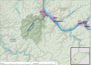 A map of Lens Creek and its watershed | |
Lens Creek is a tributary of the Kanawha River, 6.4 miles (10.3 km) long,[3] in West Virginia in the United States. Via the Kanawha and Ohio rivers, it is part of the watershed of the Mississippi River, draining an area of 19.9 square miles (52 km2)[4] on the unglaciated portion of the Allegheny Plateau, in the Charleston metropolitan area.
Lens Creek flows for its entire length in Kanawha County. It rises approximately 2.7 miles (4.3 km) north-northwest of the unincorporated community of Bloomingrose and flows generally northeastward through the unincorporated community of Hernshaw. It flows into the Kanawha River in the city of Marmet. The creek is paralleled for most of its course by West Virginia Route 94.[5][6]
The creek was named after Leonard "Len" Morris, a pioneer settler.[7]
See also
References
- ↑ The National Map elevation for GNIS source coordinates. Retrieved 2013-11-22.
- 1 2 3 Geographic Names Information System. "Geographic Names Information System entry for Lens Creek (Feature ID #1541784)". Retrieved 2013-11-22.
- ↑ United States Environmental Protection Agency. "West Virginia, Upper Kanawha Watershed". Archived from the original on 2013-11-15. Retrieved 2013-11-22.
- ↑ U.S. Geological Survey. National Hydrography Dataset, area data for Lens Creek watershed, 12-digit Hydrologic Unit Code 050500060402. The National Map, retrieved 2013-11-22
- ↑ The National Map, accessed 2013-11-22
- ↑ West Virginia Atlas & Gazetteer. Yarmouth, Me.: DeLorme. 1997. p. 52. ISBN 0-89933-246-3.
- ↑ Kenny, Hamill (1945). West Virginia Place Names: Their Origin and Meaning, Including the Nomenclature of the Streams and Mountains. Piedmont, WV: The Place Name Press. p. 368.