Lemberg (Swabian Jura)
| Lemberg | |
|---|---|
|
1899 picture ("Greetings from the Lemberg") | |
| Highest point | |
| Elevation | 1,015.3 m (3,331 ft) |
| Prominence | 365 metres (1,198 ft) |
| Coordinates | 48°09′02″N 8°44′57″E / 48.15056°N 8.74917°ECoordinates: 48°09′02″N 8°44′57″E / 48.15056°N 8.74917°E |
| Geography | |
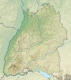 Lemberg The location within Baden-Württemberg | |
| Location | Baden-Württemberg, Germany |
| Parent range | Swabian Alps |

The Lemberg is a mountain located in the Tuttlingen district of Baden-Württemberg, Germany. The mountain is the highest point of the Swabian Jura (German: Schwäbische Alb). It is one of the "10 Thousanders"—ten 1,000-metre-high summits of the region. On the peak of the mountain is a 30-m-high tower which, reaching above the surrounding trees, offers a beautiful prospect, in clear weather as far as the Alps.
Prehistory
Like many of the mountains of the Swabian Alps, Lemberg is a "Zeugenberg"—a "witness mountain". A stratum of limestone has generally eroded away, leaving a few more-resistant remnants, such as the Lemberg.
The name is Celtic in origin. Those celtic prefix "lem-" means something like morass or sump. Probably this name derives from the source of the Bära river, a tributary of the Danube, at the foot of the mountain.
From the 8th to 5th centuries B.C. there was a Hallstatt settlement on the Lemberg. Even today walls and ditches of a fortification can be detected on the summit. In the east and the west the summit plateau was terraced. Further remains of Celtic activity are also on the neighboring mountains, and the whole Heuberg region.
Lemberg tower

By 1890 there were plans for the building of a wooden tower on the Lemberg or its neighbour, the Oberhohenberg (1,011 m). The historical significance and the comfortable ascent argued in favor of the Oberhohenberg, however finally—particularly because of status as the highest mountain of the Swabian Alps—the decision was made to build on the Lemberg. In 1894 the first terrain inspection was made by one engineer and two master craftsmen. However construction was delayed, in particular because of scarce funds. In 1897 the original plans were dropped; a discussion over the building of a tower from stone or iron began. Since the cost of a stone tower was estimated at 24,000 marks, a substantially cheaper building of iron was chosen. A company from Freiburg was assigned. The funds came predominantly from donations.
The foundations were laid in Easter week, 1899. On Whit Monday, twelve workers began with the construction of the tower. Good weather favoured the work, so that on 17 June 1899 the building was already finished. The tower ascent has over 152 stairway steps, on twelve open floors. The tower consists of 23 tons of iron. The cost estimate of 10,000 Marks was not exceeded. The observation platform of Lemberg Tower is 30 metres above ground. With the flag pole on its top the tower is 34 metres tall.
Since then, the tower has undergone refurbishing about every 25 years. Particularly after the First World War, during which the tower had also as in World War II no military importance, one played with the idea to demolish the tower in order to save the money for renovation. The suggestion did not find however sufficient proponents. The tower got in 1973 and 1999 closed for a longer time, in which it was refurbished by volunteered craftsmen from Gosheim.
In the middle of the 1980s the former telecommunication office at of Rottweil installed two directional antennas on Lember Tower for the realization of a passive repeater microwave link between the communications building in Rottweil and the trunk exchange, situated at station road in Gosheim. This microwave link, which would not have been possible on direct way, served as addition to the existing telephone interwirings. After these were replaced by optical waveguide cables, this microwave link became ever more dispensable and in the year 2005 these antennas were dismantled.
Geographical coordinates of Lemberg tower: 48°9'3" N, 8°44'56" E
Prospect
On clear days the view reaches to the south as far as the Alps, whose northern edge can be seen from the Zugspitze to the Bernese Alps. To the west lies the Black Forest, whose highest points are to be recognized: Feldberg in the southwest and Hornisgrinde in the northwest. At closer hand, the northwestern escarpment of the Swabian Alps (the Albtrauf) up to the Hohenzollern castle is to be seen, in the north the upper Neckar valley, the Schönbuch natural park, and in very good conditions even the Stuttgart TV tower, about 90 km away. Days with good viewing are more frequent in the autumn and winter than in the spring and summer.
_360%C2%B0.jpg)
Hiking access
The Lemberg can be ascended on designated hiking trails. The Schwäbische Alb-Nordrand-Weg ("Swabian Alps northern edge way"), Hauptwanderweg 1 of the Swabian Alpine Club (Schwäbischen Albverein), crosses the summit. From the nearest parking lot, the summit can be attained in about three-quarters of an hour, gaining about 180 m in elevation.
From Wilflingen, the summit can be attained in approximately one and a half hours, climbing about 400 m. The trail crosses fields before entering the forest. The final climb of the trail is narrow and steep, gaining about 130 m.
Summit shelter
On the summit of the Lemberg, the Albverein maintains a hut; a German flag is flown from the tower on days when the hut is open. The first protection hut was inaugurated on 21 June 1901. It had a surface area of 6 × 3.5 m² and was a blockhouse made from round timbers on a concrete foundation. The construction cost amounted to 800 marks.
Today's protection hut has a small guest room.
See also
External links
- "Lemberg, Germany". Peakbagger.com.
- Lemberg Tower (in German)