Geisingen
| Geisingen | ||
|---|---|---|
| ||
 Geisingen | ||
Location of Geisingen within Tuttlingen district 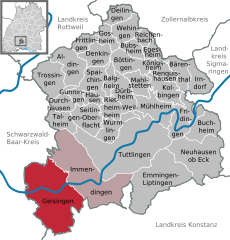
 | ||
| Coordinates: 47°55′20″N 08°38′47″E / 47.92222°N 8.64639°ECoordinates: 47°55′20″N 08°38′47″E / 47.92222°N 8.64639°E | ||
| Country | Germany | |
| State | Baden-Württemberg | |
| Admin. region | Freiburg | |
| District | Tuttlingen | |
| Government | ||
| • Mayor | Walter Hengstler | |
| Area | ||
| • Total | 73.74 km2 (28.47 sq mi) | |
| Population (2015-12-31)[1] | ||
| • Total | 6,110 | |
| • Density | 83/km2 (210/sq mi) | |
| Time zone | CET/CEST (UTC+1/+2) | |
| Postal codes | 78187 | |
| Dialling codes | 07704 | |
| Vehicle registration | TUT | |
| Website | www.geisingen.de | |

Geisingen is a town in the district of Tuttlingen, in Baden-Württemberg, Germany. It is situated on the Danube, 13 km southwest of Tuttlingen, and 21 km southeast of Villingen-Schwenningen.
History
Geisingen is referenced (spelled variously as 'Chisincs' and 'Gisinga') in deeds dated in the years 724 and 829 recorded in the monastery of St. Gallen, Switzerland, and as such is attested as one of the oldest towns in the region.[2]
Geography
The town is on the right (here, the northern) bank of the Danube at the eastern edge of a plateau known as the Baar. Where the valley of the Danube leads out of town to the east, the altitude is 2162 feet. From the peak of the Wartenberg, a conical hill (altitude: 2756 feet) which overlooks the town from the west, one can on a clear day catch a glimpse of the Swiss alps.[3]
Sons and daughters of the city
- Gustav Gihr (1894-1959), major general in the Second World War
- Siegfried Meister (1903-1982), engineer and politician (CDU), Member of Landtag, Member of Bundestag, Member of European Parliament
References
- ↑ "Gemeinden in Deutschland nach Fläche, Bevölkerung und Postleitzahl am 30.09.2016". Statistisches Bundesamt (in German). 2016.
- ↑ August Vetter Geisingen: Eine Stadtgründung der Edelfreien von Wartenburg ©1964 Südkurier GmBH Konstanz
- ↑ based on the author's visit and climb of the Wartenberg