Leighlinbridge Castle
| Leighlinbridge Castle | |
|---|---|
|
The Black Castle on the River Barrow in Leighlinbridge | |
| Location | Leighlinbridge, County Carlow, Ireland |
| Built | 14th century |
| Rebuilt | 1547 |
| Architect | Edward Bellingham (1547) |
| Architectural style(s) | Norman |
| Reference no. | 438[1] |
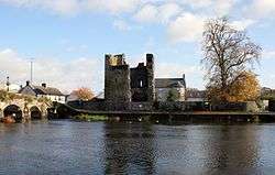
Leighlinbridge Castle, also called Black Castle, is in the village of Leighlinbridge, County Carlow, Ireland, on the River Barrow, and was one of Ireland’s earliest Norman castles. A 50-foot-tall (15 m) broken castle tower and bawn wall are all that can be seen today.[2]
History
One source says that in 1180 Hugh de Lacy built the first castle here to defend the river crossing,[3][4] while another states that in 1181, John de Clahull built one of the earliest strongholds of The Pale here. The present building is, however, a 14th-century Tower house. Beside the castle was a Carmelite priory, founded in 1270.[5] During the 14th century, the Cavanaghs reclaimed most of their land in the area, including the castle.[3] The castle was rebuilt in 1547 by Edward Bellingham as Black Castle, and a band of horse was kept there, under whose protection the county slowly settled. The castle was situated in the Barony of Idrone owned by the Carews.[6] The castle was sacked by Cromwellian forces in 1650 during the Irish Confederate Wars.[2]
Features
A broken castle tower, 50 feet tall, and the bawn wall compose the ruins seen today.[2] All that remains is the left half of the 14th-century tower and part of the bawn.[3][4]
References
- ↑ National Monuments in County Carlow
- 1 2 3 "Leighlinbridge Castle". An Ireland Attraction.
- 1 2 3 "Leighlinbridge Castle". South East Ireland.com. Retrieved 2007-12-10.
- 1 2 "Leighlinbridge Castle". Carlow Tourism - Castles. Archived from the original on March 11, 2005. Retrieved 2007-12-10.
- ↑ "Leighlinbridge Castle". Go Ireland.com. Retrieved 2007-12-10.
- ↑ "Biography of Sir Nicholas Bagenal". Bagnall Village.com. Retrieved 2007-12-10.
| Wikimedia Commons has media related to Leighlinbridge Castle. |
Coordinates: 52°44′09″N 6°58′41″W / 52.7357°N 6.9781°W