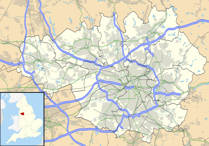
Leigh, Greater Manchester
| Leigh | |
 Obelisk and the Boar's Head |
|
 Leigh |
|
| Population | 52,855 [1] |
|---|---|
| OS grid reference | SD655005 |
| – London | 169 mi (272 km) SSE |
| Metropolitan borough | Wigan |
| Metropolitan county | Greater Manchester |
| Region | North West |
| Country | England |
| Sovereign state | United Kingdom |
| Post town | LEIGH |
| Postcode district | WN7 |
| Dialling code | 01942 |
| Police | Greater Manchester |
| Fire | Greater Manchester |
| Ambulance | North West |
| EU Parliament | North West England |
| UK Parliament | Leigh |
|
|
Coordinates: 53°29′51″N 2°30′54″W / 53.4975°N 2.5150°W
Leigh is a town in the Metropolitan Borough of Wigan, Greater Manchester, England, 7.7 miles (12 km) southeast of Wigan and 9.5 miles (15.3 km) west of Manchester city centre. Leigh is situated on low-lying land to the north west of Chat Moss.
Historically a part of Lancashire, Leigh was originally the centre of a large ecclesiastical parish covering six vills or townships. When the three townships of Pennington, Westleigh and Bedford merged in 1875 forming the Leigh Local Board District, Leigh became the official name for the town although it had been applied to the area of Pennington and Westleigh around the parish church for many centuries.[2] The town became an urban district in 1894 when part of Atherton was added.[3] In 1899 Leigh became a municipal borough. The first town hall was built in King Street and replaced by the present building in 1907.
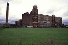
Originally an agricultural area noted for dairy farming, domestic spinning and weaving led to a considerable silk and, in the 20th century, cotton industry. Leigh also exploited the underlying coal measures particularly after the town was connected to the canals and railways. Leigh had an important engineering base. The legacy of Leigh's industrial past can be seen in the remaining red brick mills – some of which are listed buildings – although it is now a mainly residential town, with Edwardian and Victorian terraced housing packed around the town centre. Leigh's present-day economy is based largely on the retail sector.
History
Toponymy
Leigh is derived from the Old English leah which meant a place at the wood or woodland clearing, a glade and subsequently a pasture or meadow, it was spelt Legh in 1276.[4] Other recorded spellings include Leech, 1264; Leeche, 1268; Leghthe, 1305; Leght, 1417; Lech, 1451; Legh, 16th century. As its name denotes it was a district rich in meadow and pasture land, and the produce of its dairies, the Leigh cheese, was formerly noted for its excellence.[2] Westleigh, the west clearing, was Westeley in 1237, Westlegh in 1238 and Westlay in Legh in 1292.[5] Pennington was recorded as Pininton and Pynynton in 1246 and 1360, Penynton in 1305, Pynyngton in 1351 and 1442 and Penyngton in 1443, the ending tun denotes an enclosure, farmstead or manor in Old English.[6] The ford of Beda, probably through the Pennington Brook gave its name to Bedford which was recorded as Beneford from 1200–21 and Bedeford in 1200 and 1296.[7]
Early history
The earliest signs of human activity in Leigh are evidenced by a Neolithic stone axe found in Pennington and a bronze spearhead from south of Gas Street.[8] A single Roman coin was found at Butts in Bedford.[9] After the Roman departure from Britain, and into the history of Anglo-Saxon England, nothing was written about Leigh. However evidence for the presence of Saxons in what was a sparsely populated and isolated part of the country is provided by local township place names that incorporate the Old English suffix leah, such as Leigh, Tyldesley, Shakerley and Astley.[10]
Townships
In the 12th century the ancient parish of Leigh was made up of six townships, including Pennington,[11] Bedford,[12] Westleigh,[13] Atherton, Astley, and Tyldesley cum Shakerley. Weekly markets were held by the parish church and a cattle fair held twice-yearly.[14]
Bedford manor was mentioned in documents in 1202 when it was held by Sir Henry de Kighley whose family held it until the 16th century, but never actually lived there.[7] The Shuttleworths, landowners from the 14th century, were another prominent Bedford family. Richard Shuttleworth married a daughter of the Urmstons from Westleigh and brought part of the Westleigh inheritance to Bedford. This family lived at Shuttleworth House, or Sandypool Farm as it is also known, which is south of the Bridgewater Canal near to the old manor house, Bedford Hall, which survives today as a Grade II listed building.[7][15] Another prominent Bedford family, the Sales of Hope Carr Hall, had a great deal of influence in Bedford for over 400 years, and owned more land than the Shuttleworths.[7] The family were recusants and secretly kept the "old faith" when Roman Catholicism was subject to civil or criminal penalties. Hope Carr Hall was moated as was nearby Brick House.[9]
The manor house of Westleigh was at Higher Hall and existed in Richard I's time (1189–1199).[5] In 1292 Sigreda, the heiress of the manor, married Richard de Urmston, and the manor passed to the Urmston family and remained there until the last of the male Urmstons died in 1659.[5] It was later abandoned because of mining subsidence and Westleigh Old Hall became the manor by repute. The Ranicars and the Marsh families lived here.[5] Westleigh Old Hall was another Leigh hall that had a moat.[9]
The Pennington family owned Pennington Hall from about 1200 until they were replaced by the Bradshaw or Bradshaighs in 1312.[6] The Bradshaws held the manor until 1703 when John, the last of the male line died. Pennington Hall was rebuilt in 1748 by the then owner Samuel Hilton and in 1807 sold to the Gaskell family of Thornes, Wakefield, who let it to a succession of tenants.[6] Around 1840 James Pownall, a founder member of the silk manufacturing firm, Bickham and Pownall, was tenant. Later occupants were Charles Jackson, cotton manufacturer, Jabez Johnson, and F.W. Bouth founder of Bouth's Mill in 1862, The last resident was the brewer, George Shaw. On 3 December 1919 George Shaw & Co Ltd offered the hall and grounds to the people of Leigh. The gift was accepted and opened to the public on 25 August 1920.[16] The hall was converted to a museum and art gallery in 1928 but was demolished in 1963. The grounds are now Pennington Park.
Civil War
Leigh was divided in its allegiance during the English Civil War, some of the population supporting the Royalists' cause while others supported the Parliamentarians. A battle was fought in the town on 2 December 1642, when a group of Chowbenters, men from neighbouring Atherton, beat back and then routed Cavalier troops under the command of James Stanley, the 7th Earl of Derby. Sir Thomas Tyldesley of Myerscough and Morleys Hall, Astley, was killed on 25 August 1651 at the Battle of Wigan Lane and is buried in the Tyldesley Chapel in Leigh Parish Church.[9] The Earl of Derby passed through Leigh again in 1651, when he spent his last night in the King's Arms, before going on to his execution outside Ye Olde Man & Scythe Inn in Bolton.[9]
Industrial Revolution
At the end of the 16th century, although agriculture and the dairy industry, particularly the production of Leigh cheese, sometimes known as Leigh Toaster, were important,[17] spinning and weaving began to develop as a cottage industry. Work was supplied from Manchester by agents who brought work weekly often to an inn, and where they collected the finished cloth. At first the work was done to supplement the income of local farmers and their families. The cloth woven in Leigh was fustian, a sort of rough corduroy, and by the end of the 17th century middlemen, fustian masters, were dealing directly with weavers and selling the finished cloth in Manchester.[18] It is a tradition in the town that a local man, Thomas Highs, was the inventor of a spinning jenny and the water frame in the 1760s, the latter invention being pirated by Richard Arkwright, who subsequently made a fortune from the patent royalties.[19] These 18th-century improvements to the spinning process meant that handloom weavers were in great demand.[20] but as power looms were introduced in factories in Manchester there was less work for them and there was serious unemployment in the town. In 1827 silk weaving began in Leigh, either as the result of a dispute or a labour shortage in the Middleton silk industry. William Walker was a middleman who opened the first silk mill in Leigh in 1828, and others quickly followed, including James Pownall and Henry Hilton, whose mill survived until 1926.[21][22] Several cotton mills were built in Leigh after the mid-1830s, and some silk mills were converted to cotton after 1870.[9]
The Leigth Feight took place on 14 August 1839. The chartists had called for a strike at a time when there was social unrest over the high levels of unemployment and high cost of living. A mob of at least 2,000 gathered in Leigh. About 400–500 workers from Chowbent threatened to burn down Hayes Mill. A detachment of troops from Haydock was called out and special constables sworn in by the local magistrate. The Riot Act was read by Squire Thomas Withington of Culcheth Hall and for a while the mob dispersed but reassembled later. Many were injured in the fighting that took place and arrests were made. Those arrested were severely punished, while others ensured that radicalism continued in Leigh, leading eventually to electoral reform and universal suffrage.[23]
The large multi-storey spinning mills came later, and five survive today. Mill complexes were built at Kirkhall Lane and Firs Lane in Westleigh, and in Pennington and Bedford.[9] Leigh Spinners[24] is a Grade II* listed building. Mather Lane Mill close to the Bridgewater Canal is a Grade II listed building.[25] More than 6,000 people were employed in textiles in Leigh in 1911.[9]
Coal mining

There had been drift mines in Westleigh since the 12th century but during the second half of the 19th century it became possible to mine the deeper seams and coal began to be an important industry and coal mining became the largest user of labour after the textile industry in Leigh.[26] Parsonage Colliery, the last pit to be sunk in Leigh, was one of the deepest in the country, going down to over 3,000 ft (900 m).[27] The extent of mining at Parsonage Colliery increased in the 1960s with the driving of the Horizon Tunnel, which accessed previously inaccessible seams around 6 ft (2 m) high that were easy to work. The seams were wet, and a series of pumps was used to remove the water into underground canals before it was pumped into the canal at Leigh. The winding engine at Parsonage was a steam engine, fuelled by methane extracted from the workings, while the neighbouring Bickershaw Colliery had a superior electric system. In 1974, the two pits were linked underground, and all coal was wound at Bickershaw, which had better facilities, while Parsonage was used for supplies. The entire Lancashire Coalfield is closed to deep mining, although several open-cast mines are still in operation elsewhere in the county.
Mining disasters in Leigh included the explosion of firedamp which caused the deaths of 38 miners at Bedford Colliery on 13 August 1886.[28] There were several accidents at Bickershaw Colliery, but the most serious was in 1932, when 19 men were drowned in the sump at the bottom of the shaft after an overwind of the cage.[29][30]
| Colliery Name | Location | Owner | List & Ref. |
|---|---|---|---|
| Bankfield | Westleigh | J. Speakman | 1880[31] |
| Bedford Colliery | Bedford | J. Speakman & Sons | 1880 1908[31] |
| Bickershaw Colliery | Westleigh | Ackers Whitley & Co | 1854[31][32] 1918 |
| Broadfield | Westleigh | John Speakman and Co. | 1854[32] 1869 1880[31] |
| Hearts o' th' Meadow | Westleigh | Wigan Coal and Iron Co. | 1880[31] |
| Heyfield | Westleigh | Thomas Livesey | 1854[32] 1869 1880 1908 1918[31] |
| Lower Hall | Westleigh | James Diggle | 1880, 1908, 1918[31] |
| Owens | Westleigh | James Diggle | 1869[31] |
| Parsonage Colliery | Westleigh | Wigan Coal and Iron Company | 1918[31] |
| Priestners | Westleigh | Wigan Coal and Iron Company | 1880, 1908[31] |
| Sovereign | Westleigh | Wigan Coal and Iron Company | 1908, 1918[31] |
| Snapes | Westleigh | James Diggle | 1869, 1880, 1908[31] |
| Westleigh | Westleigh | James Diggle and Co. | 1854[32] 1869, 1880, 1918[31] |
| Westleigh Lane | Westleigh | Samuel Banks | 1854[31][32] |
Manufacturing
Other notable industry included the tractor factory of David Brown Limited, which was located in Leigh following the acquisition in 1955 of Harrison, McGregor and Guest's Albion range of farm machinery products.[33] Rope-manufacture was another local industry: Mansley's Rope works on Twist Lane made rope by hand, using a rope walk. The factory burnt down in 1912.[34] Anchor Cables had a large works close to the Bridgewater Canal. The company was bought by Callender's Cables, in 1903, later to become British Insulated Callender's Cables (BICC), part of Balfour Beatty.[35] Another major 20th century employer was Sutcliffe Speakman, which made activated carbon and brick-making equipment.[36]
Governance

Leigh is covered by four electoral wards, Atherleigh, Leigh East, Leigh South and Leigh West, of the Metropolitan Borough of Wigan. Each ward elects three councillors to the 75-member metropolitan borough council, Wigan's local authority. As of 2009, all twelve ward councillors for Leigh, including Leader of the Council, Lord Smith of Leigh, are members of the Labour Party who control the council.[37]
Historically, Leigh's townships were in the Hundred of West Derby, a judicial division of southwest Lancashire. Pennington, Westleigh and Bedford were three of the six townships or vills that made up the ancient parish of Leigh. The townships existed before the parish.[2]

Under the terms of the Poor Law Amendment Act 1834 the townships formed part of Leigh Poor Law Union, established on 26 January 1837 and responsible for an area covering the whole of the ancient parish and part of Winwick. Workhouses in Pennington, Culcheth, Tyldesley and Lowton were replaced by Leigh Union workhouse at Atherleigh in the 1850s.[38] In 1875 Leigh Local Board of Health was established, covering the areas of the former Bedford, Pennington and Westleigh Local Boards of Health. In 1894 the area of the Local Board, together with part of Atherton township, became Leigh Urban District, which was granted honorific borough status in 1899 becoming the Municipal Borough of Leigh. In 1969 there was an exchange of very small areas with Golborne Urban District. Following the Local Government Act 1972, the Municipal Borough of Leigh was abolished and its territory granted as part of the Metropolitan Borough of Wigan, a local government district of Greater Manchester.[39] In 1998, an area (Lately Common) was further ceded to the Warrington borough – one of the few parts of England to have been in three different counties since the mid-20th century: Lancashire, then Greater Manchester, then Cheshire.
Leigh's MP is Andy Burnham who has represented the parliamentary seat for Leigh for the Labour Party since the 2001 General Election. Between 10 June 2009 and the 2010 General Election he was Secretary of State at the Department of Health.[40] At the 2010 General Election Burnham retained the Leigh seat with 24,295 votes and a majority of 15,011, representing 51.3% of the vote.[41] Burnham was re-elected MP for the Leigh constituency in 2015 with 24,312 votes which was 53.9% of the total vote cast.[42]
Geography
| Leigh | ||||||||||||||||||||||||||||||||||||||||||||||||||||||||||||
|---|---|---|---|---|---|---|---|---|---|---|---|---|---|---|---|---|---|---|---|---|---|---|---|---|---|---|---|---|---|---|---|---|---|---|---|---|---|---|---|---|---|---|---|---|---|---|---|---|---|---|---|---|---|---|---|---|---|---|---|---|
| Climate chart (explanation) | ||||||||||||||||||||||||||||||||||||||||||||||||||||||||||||
| ||||||||||||||||||||||||||||||||||||||||||||||||||||||||||||
| ||||||||||||||||||||||||||||||||||||||||||||||||||||||||||||
Leigh is low-lying; land to the south and east, close to Chat Moss, is 50 feet (15 m) above mean sea level.[2] The highest land, to the north and west, rises gently to 125 feet (38 m). Astley and Bedford Mosses are fragments of the raised bog that once covered a large area north of the River Mersey and along with Holcroft and Risley Mosses are part of Manchester Mosses, a European Union designated Special Area of Conservation.[44] The area is in the River Mersey Basin; drained into the Mersey by several streams, including the Westleigh and Pennington Brooks that join others flowing through Bedford to form the Glaze Brook.[2] The southeast of the town has alluvial and peaty soils,[7] but the rest is loam overlaying sandstone, or coal measures in the north.[5][7] magnesian limestone occurs in Bedford and neighbouring Astley.[2] Mining subsidence and flooding have caused the formation of "flashes" to the south and west of the town, the largest of which is south of the Leeds and Liverpool Canal in Pennington. Pennington Flash Country Park is a 490-acre (200 ha) country park and nature reserve with a 170-acre (69 ha) flash or lake.[45]
Leigh is crossed by the Bolton to St Helens Road high road,[2] an old packhorse route that became a Turnpike Trust in 1762.[20] The A579 road bypasses the town centre using the line of the Bolton and Leigh Railway. The Bridgewater Canal and the Leigh Branch of the Leeds and Liverpool Canal cross the town west to east, the canals meeting at Leigh Bridge just south of the town centre.[6][46] In the 1930s the A580 "East Lancashire Road" was built crossing to the south of the town.
 |
Hindley | Atherton | Tyldesley | |
| Abram | |
Astley | ||
| ||||
| | ||||
| Lowton | Culcheth | Chat Moss |
Demography
| Leigh Compared | ||||
|---|---|---|---|---|
| 2001 Census | Leigh | Wigan MB | GM Urban Area | England |
| Total population | 43,006 | 301,415 | 2,240,230 | 49,138,831 |
| White | 98.3% | 98.7% | 90.3% | 90.9% |
| Asian | 0.8% | 0.4% | 6.2% | 4.6% |
| Black | 0.2% | 0.2% | 1.3% | 2.3% |
| Source: Office for National Statistics[47][48] | ||||
At the time of the United Kingdom Census 2001, according to the Office for National Statistics, the Urban Subdivision of Leigh[49] was part of the Greater Manchester Urban Area and had a total resident population of 43,006, of which 20,990 (48.8%) were male and 22,016 (51.2%) were female, with 18,270 households.[50] The settlement occupied 884 hectares (3.41 sq mi), compared with 858 hectares (3.31 sq mi) in the 1991 census. Its population density was 48.65 people per hectare compared with an average of 40.20 across the Greater Manchester Urban Area.[51] The median age of the population was 37, compared with 36 within the Greater Manchester Urban Area and 37 across England and Wales.[52]
The majority of the population of Leigh were born in England (95.92%); 2.10% were born elsewhere within the United Kingdom, 0.95% within the rest of the European Union, and 1.47% elsewhere in the world.[53]
Data on religious beliefs across the town in the 2001 census show that 85.5% declared themselves to be Christian, 7.6% said they held no religion, and 0.6% reported themselves as Muslim.[54]
Most of Leigh is within the Warrington & Wigan Travel to Work Area (TTWA), whilst part of the eastern side of the town is within the Manchester TTWA.[55] The entire town is within the Manchester Larger Urban Zone.[56]
At the time of the 2001 Census, there were 19,051 people (44.3%) in employment who were resident within Leigh. Of these, 18.36% worked within the wholesale and retail trade, including repair of motor vehicles; 21.60% worked within manufacturing industry; and 11.99% worked within the health and social work sector.[57] 45.16% of households owned a single car or van, with 30.77% owning none. The average car ownership per household was 0.98, compared with 0.93 across the Greater Manchester Urban Area.[50]
Population change
| Population growth in Leigh from 1801 to 2001 | |||||||||||
|---|---|---|---|---|---|---|---|---|---|---|---|
| Year | 1801 | 1811 | 1821 | 1831 | 1841 | 1851 | 1861 | 1871 | 1881 | 1891 | |
| Population | no data | no data | 18,372 | 20,083 | 28,568 | 5,206 | 10,621 | no data | no data | 28,708 | |
| Year | 1901 | 1911 | 1921 | 1931 | 1939 | 1951 | 1961 | 1971 | 1981 | 1991 | 2001 |
| Population | 40,001 | 44,103 | 45,532 | 45,317 | 45,458 | 48,728 | 46,174 | no data | 42,929 | 43,150 | 43,006 |
|
Parish 1821–1861[58][59][60] • Urban Sanitary District 1891[61] • Urban District 1901–1961[62] • Urban Subdivision 1981–2001[63][64][65] | |||||||||||
Economy

Leigh has a traditional town centre with daily outdoor and indoor markets.[66] Part of the town centre is pedestrianised and there are local independent and multiple retailers. The Spinning Gate Centre in the centre of town has about thirty retail units.[67] A retail park developed on the old Parsonage Colliery site is within walking distance of the town centre.[68]
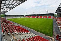
Opened in 2008 Leigh Sports Village has an 11,000-capacity stadium (anchored by Leigh Centurions and shared with the reserves of Blackburn Rovers), an athletics arena for Leigh Harriers, facilities for Leigh East Rugby League Club, a college campus, hotel, leisure retail and business facilities for the community.[69] In 2011 a Morrisons store opened at the sports village.[70]
Another regeneration project on the site of the former Bickershaw Colliery complex which closed in 1992 will redevelop the site and canal side with a country park and housing.[71] In 2011 "The Loom" a £50million retail development opened on the north side of the Bridgewater Canal with a seven-screen cinema, Tesco Extra store, Nando's, Frankie and Benny's and The Real China restaurants.[72]
Landmarks
Major landmarks in Leigh are the red sandstone parish church and across the civic square, Leigh Town Hall and its associated shops on Market Street. The Grade II listed Obelisk that replaced the original market cross is also situated here.[73] Many town centre buildings including the Boar's Head public house[74] are in red Ruabon or Accrington bricks, often with gables and terracotta dressings.[9] There are several large multi-storey cotton mills built along the Bridgewater Canal that are a reminder of Leigh's textile industry but most are now underused and deteriorating despite listed building status.[75] Leigh's War Memorial by local architect J.C. Prestwich is at the junction of Church Street and Silk Street and is a Grade II listed structure.[76] St Joseph's Church and St Thomas's Church on opposite sides of Chapel Street are both imposing churches using different materials and styles.
Transport

Historically Leigh was well connected to the local transport infrastructure, but with the closure of the railway in 1969 this is no longer the case. Public transport is co-ordinated by the Transport for Greater Manchester. There are bus services operated by First Greater Manchester, Jim Stones, Maytree Travel, Diamond Bus North West, Stagecoach Manchester and Network Warrington from Leigh bus station to many local destinations including Wigan, Bolton, Warrington, Manchester and St Helens.[77] There had been suggestions to reopen the railway via Tyldesley to Manchester, but a guided busway[78] scheme was chosen for the route; this decision was not universally popular.[79]
Canals
The Bridgewater Canal was extended from Worsley to the middle of Leigh in 1795.[80][81] In 1819 the fifth Leeds and Liverpool Canal Act was passed for the construction of the Leigh Branch and by 1820 the Leigh branch canal was cut from the Leeds and Liverpool Canal at Poolstock, Wigan to meet the Bridgewater at Leigh Bridge, giving access from Leigh to all parts of Lancashire, Yorkshire and the Midlands.[82]
Railways
Leigh was the southern terminus of the 7.5 miles (12 km) long Bolton and Leigh Railway. George Stephenson carried out the survey for the line. It opened between Bolton and William Hulton's coal mines at Chequerbent for freight on 1 August 1828 and to the terminus at the Leeds and Liverpool Canal at Leigh in March 1830.[83] Passengers were carried from 13 June 1831. The first locomotive on the line was an 0-4-0 called the Lancashire Witch. The railway station was at Westleigh.[84] Later the line was extended southwards to Pennington.[85] Atherleigh opened in 1935. The line was closed to passenger traffic on 29 March 1954, and later closed completely.[86]
In 1861 the London and North Western Railway revived powers granted to the Lancashire and Yorkshire Railway to build a railway from Manchester via Eccles and Tyldesley to Wigan with a branch to Kenyon Junction on the Liverpool to Manchester Line via Leigh and Pennington.[87] The station, originally named Bedford Leigh served the town. The railway crossed the town on a viaduct which has since been largely demolished.[88] It closed in May 1969, leaving the town without a railway: after the reopening of Mansfield and Corby railway stations, Leigh is now one of the largest towns in Great Britain without a railway station. Numerous colliery lines crossed the town, but with the closure of the collieries these were no longer required.
The nearest railway station is at Atherton, 3 miles (5 km) miles to the north, with trains to Wigan and Manchester operated by Northern, leaving the bus station as Leigh's only public transport link.
Trams and trolley buses
In 1900, a Bill authorising the South Lancashire Tramways Company to construct over 62 miles (100 km) of tramway in southern Lancashire was given Royal Assent.[89] However, by November 1900 the South Lancashire Electric Traction and Power Company had acquired the shares. The first section of tramway opened on 20 October 1902 between Lowton and Four Lanes Ends via Leigh and Atherton. The company got into financial difficulty and in turn became Lancashire United Tramways later Lancashire United Transport. On 16 December 1933, the last tram service ran from Leigh to Four Lane Ends and the next day trolley buses took over.[90] An Act of 4 August 1920 authorised Leigh Municipal Borough to run buses. A garage built on Windermere Road was soon outgrown and replaced by one on Holden Road. The corporation had a fleet of 70 vehicles during World War II.[91]
Work on the Leigh-Salford-Manchester Bus Rapid Transit guided busway commenced in 2012[92] and the busway opened on 3 April 2016[93]
Education

Leigh Grammar School existed in 1655 but its foundation is unclear. The building was next to the churchyard,[94] but the school moved to Manchester Road in 1931. Leigh Girls' Grammar School was established in 1921,[94] but both schools were abolished by the then Secretary of State for Education, Shirley Williams, in the 1976 Education Act. Leigh high schools include Bedford High School,[95] and Westleigh High School.[96] Pupils also attend schools in Atherton, Lowton, Golborne and Astley. Wigan and Leigh College provides post-16 education.
Religion

St Mary the Virgin's Church has been in existence since the 12th century and probably much earlier.[9] It was once known as the Church of St Peter at Westleigh in Leigh, and straddles the boundary between the old townships of Westleigh and Pennington, the nave and churchyard, in Westleigh and the chancel in Pennington. Its early history is connected with the Westleigh and Urmston families. Its dedication changed to St Mary the Virgin in the 14th century.[2] The church tower, said to have been built in 1516, is all that remains of the medieval structure, which was replaced by the present church after becoming unsafe. Paley and Austin of Lancaster designed the present church, the foundation stone was laid in 1871 and the church consecrated in 1873. The church is built in red sandstone it is a Grade II listed building.[97]
Parish churches have been built in each of the former townships. The first St Thomas's Church in Bedford was consecrated in 1840 and replaced by the present church in 1909. It is built of Accrington red brick with Runcorn red sandstone facings, to designs by J. S. Crowther.[98] Christ Church, Pennington, designed by architect E. H. Shellard, was built in Yorkshire stone and was consecrated in 1854. The site to the south of the canal was a rapidly growing area at this time. It is Grade II listed.[99] Westleigh St Paul, founded in 1847 is on Westleigh Lane. Westleigh St Peter, a Grade II* listed building by Paley and Austin, built in brick with red sandstone dressings, was founded 1881 is on Firs Lane.[100]
The first Catholic chapel was built in Bedford on the corner of Mather Lane and Chapel Street in 1778 and this lasted until it was replaced in 1855 by St Joseph's Church by architect Joseph Hansom.[101] A growing Catholic population in the area led to the building of Our Lady of the Rosary in Plank Lane in 1879, Twelve Apostles in 1879 and Sacred Heart in 1929. Other denominations catered for include Wesleyan, Independent, Primitive, Welsh and United Methodists. There are also Unitarian, Baptist and Jehovah's Witness places of worship in the town.[102]
Sport
Leigh has a professional rugby league team – Leigh Centurions[103] – whose main claim to fame is beating Leeds 24–7 in the 1971 Challenge Cup final at Wembley Stadium. The club played in the Super League in the 2005 season. Leigh has several amateur clubs, including Leigh East and Leigh Miners Rangers.
The town had a semi-professional football team, Leigh Genesis (formerly Leigh RMI),[104] which ceased operations at a senior level in June 2011. The most successful amateur club is Leigh Athletic,[105] which currently plays in the Manchester Football League.
Leigh also has an athletics club, Leigh Harriers AC, founded in 1909,[106] and a Rugby Union club, Leigh RUFC, based at Round Ash Park, which gained promotion in 2007, to RFU league North 2 (West), and is current holder of the Lancashire Trophy which it won in May 2008 for the third consecutive year. Attached to the club is a crown green bowling section which runs several teams in local bowling leagues.[107] Leigh has two cricket clubs: Leigh Cricket Club play in the ECB Premier League Liverpool Competition,[108] and Westleigh Cricket Club,[109] have two senior and 4 junior teams playing in the Bolton and District Cricket Association.[110]
Culture
Many of Leigh's old halls have been demolished but the sites of Lilford Park, once the grounds of Atherton Hall, a gift to Leigh from Lord Lilford in 1914[111][112] and Pennington Park, the grounds of Pennington Hall which was demolished in 1963 after being used as a museum, are open to the public.[113]
Leigh's wealth as an industrial town resulted in many outlets for the entertainment of its population, including theatres, cinemas and public houses. In 1908 the Hippodrome Theatre on Leigh Road was built on the site of Walker's silk mill of 1827, this subsequently became a cinema, first the Odeon, later the Classic.[114] Another theatre, the Theatre Royal, was built on Lord Street which later became the Leigh Casino Club.[115] The Palace Cinema was built in 1913 on Railway Road and the assembly rooms above the Conservative Club, were converted to a cinema known as the Sems in 1908.[116] Brewery Lane is a reminder that there was once a brewery in Bedford belonging to George Shaw & Co.[117] The old Leigh College and Library on Railway Road was built between 1894 and 1896 by the Leigh Literary Society to designs by J. C. Prestwich and J. H. Stephen.[118] The present library was built in 1971 between the parish church and town hall.[119]
Notable people
Sir John Lennard-Jones, Sir Peter Maxwell Davies[120] and Pete Shelley[121] were old pupils of Leigh Grammar School. Rhythm and blues singer and musician Georgie Fame was born in Leigh in 1943.[122] Thomas Burke, operatic tenor, was born in 1890 and attended St Joseph's School.[123] The author of "Goodbye, Mr Chips", James Hilton was also born in Leigh. A local businessman of the same name became chairman of Leigh RLFC after World War II and the club's former ground, Hilton Park, was named after him.[124] The female sculptor Mary Pownall (1862-1937) was born and raised in Leigh. [125]
See also
References
Notes
- ↑ Census 2011: Population and Household Estimates for Wards (pdf), Wigan Council, retrieved 19 May 2016
- 1 2 3 4 5 6 7 8 Farrer, William; Brownbill, J, eds. (1907), "The parish of Leigh: Introduction, church and charities", A History of the County of Lancaster: Volume 3, British History Online, pp. 413–421, retrieved 7 August 2009
- ↑ Greater Manchester Gazetteer, Greater Manchester County Record Office, archived from the original on 18 July 2011, retrieved 3 June 2010
- ↑ Mills (1998), p. 218.
- 1 2 3 4 5 Farrer, William; Brownbill, J, eds. (1907), "Westleigh", A History of the County of Lancaster: Volume 3, British History Online, pp. 421–426, retrieved 28 July 2009
- 1 2 3 4 Farrer, William; Brownbill, J, eds. (1907), "Pennington", A History of the County of Lancaster: Volume 3, British History Online, pp. 426–431, retrieved 28 July 2009
- 1 2 3 4 5 6 Farrer, William; Brownbill, J, eds. (1907), "Bedford", A History of the County of Lancaster: Volume 3, British History Online, pp. 431–435, retrieved 28 July 2009
- ↑ 25 things you never knew about Leigh (PDF), Wian Council, archived from the original (PDF) on 2 February 2012, retrieved 31 January 2011
- 1 2 3 4 5 6 7 8 9 10 LeighTownTrailPart1 (PDF), Wigan.gov.uk, retrieved 14 August 2009
- ↑ Mills (1998), p. 405.
- ↑ Pennington, genuki.org.uk, retrieved 9 August 2009
- ↑ Bedford, genuki.org.uk, retrieved 9 August 2009
- ↑ Westleigh, genuki.org.uk, retrieved 9 August 2009
- ↑ LeighTownTrailPart1 (PDF), Wigan.gov.uk, p. 6, archived from the original (PDF) on 29 September 2011, retrieved 14 August 2009
- ↑ Bedford Hall, Images of England, retrieved 10 September 2009
- ↑ [Leigh Chronicle - Pennington Hall, (8 April 1949)]
- ↑ Leigh Cheese (PDF), wlct, p. 30, archived from the original (PDF) on 28 September 2007, retrieved 18 October 2009
- ↑ Ackers (1978), p. 3.
- ↑ Richard Guest (1823), A Compedious History of the Cotton-Manufacture, retrieved 25 August 2009
- 1 2 Ackers (1978), p. 4.
- ↑ Ackers (1978), p. 8.
- ↑ Holcroft (1998), p. 10.
- ↑ Lunn (1958), pp.84–86.
- ↑ Leigh Mill, Park Lane, Images of England, retrieved 10 September 2009
- ↑ Mather Lane Mill, Images of England, retrieved 10 September 2009
- ↑ Ackers (1978), p. 11.
- ↑ Parsonage Colliery 1934, hansard.millbanksystems.com, retrieved 19 September 2009
- ↑ Bedford Colliery Disaster (PDF), cmhrc.co.uk, p. 1, retrieved 1 November 2009
- ↑ Bickershaw Colliery Disaster, communigate.co.uk, retrieved 1 November 2009
- ↑ Bickershaw Colliery Disaster (PDF), cmhrc.co.uk, p. 4, retrieved 1 November 2009
- 1 2 3 4 5 6 7 8 9 10 11 12 13 14 "Lists of UK Mines". Coal Mining History Resource Centre. Retrieved 7 July 2009.
- 1 2 3 4 5 "East Lancashire". communigate.co.uk. Retrieved 1 November 2009.
- ↑ David Brown Tractors, dbtc.co.uk, retrieved 9 August 2009
- ↑ LeighTownTrailPart2 (PDF), Wigan.gov.uk, retrieved 10 September 2009
- ↑ Morgan, R. M. (1982). Callender's 1888–1945. Prescott: BICC plc, Chapter 7; "Anchor Works".
- ↑ Sutcliffe Speakman (PDF), sutcliffespeakman.com, archived from the original (PDF) on 28 November 2006, retrieved 25 August 2009
- ↑ Wigan Metropolitan Borough Council, Councillor & Committee Details, wigan.gov.uk, retrieved 15 August 2009
- ↑ Leigh, workhouses.org.uk, archived from the original on 5 June 2011, retrieved 16 August 2009
- ↑ Greater Manchester Gazetteer, Greater Manchester County Record Office, Places names – I-L, archived from the original on 18 July 2011, retrieved 15 August 2009
- ↑ Andy Burnham MP, theyworkforyou.com, retrieved 11 November 2009
- ↑ "Election 2010: Leigh", BBC News, retrieved 7 May 2010
- ↑ "Election 2015: Leigh", BBC News, retrieved 11 May 2015
- ↑ Leigh Weather, United Kingdom Weather Averages, retrieved 23 September 2012
- ↑ Manchester Mosses, Joint Nature Conservation Committee, retrieved 23 September 2012
- ↑ Wigan Metropolitan Borough Council, Parks, wigan.gov.uk, archived from the original on 24 April 2009, retrieved 25 August 2009
- ↑ penninewaterways, Canals, penninewaterways.co.uk, retrieved 25 August 2009
- ↑ "Census 2001 Key Statistics – Urban area results by population size of urban area", ons.gov.uk, Office for National Statistics, KS06 Ethnic group
 , 22 July 2004, retrieved 16 February 2009
 - ↑ "Census 2001 Key Statistics, Urban area summary results for local authorities", ons.gov.uk, Office for National Statistics, KS06 Ethnic group , 22 July 2004, retrieved 16 February 2009
- ↑ D90223 : Greater Manchester Urban Area – Leigh (urban area subdivisions) map, National Statistics, retrieved 24 September 2009
- 1 2 "Census 2001 Key Statistics – Urban area results by population size of urban area", ons.gov.uk, Office for National Statistics, KS17 Cars or vans , 22 July 2004, retrieved 16 February 2009
- ↑ "Census 2001 Key Statistics – Urban area results by population size of urban area", ons.gov.uk, Office for National Statistics, KS01 Usual resident population , 22 July 2004, retrieved 16 February 2009
- ↑ "Census 2001 Key Statistics – Urban area results by population size of urban area", ons.gov.uk, Office for National Statistics, KS02 Age structure , 22 July 2004, retrieved 16 February 2009
- ↑ "Census 2001 Key Statistics – Urban area results by population size of urban area", ons.gov.uk, Office for National Statistics, KS05 Country of birth , 22 July 2004, retrieved 16 February 2009
- ↑ "Census 2001 Key Statistics – Urban area results by population size of urban area", ons.gov.uk, Office for National Statistics, KS07 Religion , 22 July 2004, retrieved 16 February 2009
- ↑ Travel to Work Areas, Office for National Statistics, ISBN 0-08-040771-4, archived from the original on 1 October 2008, retrieved 24 September 2008
- ↑ Towards a Common Standard (PDF), Greater London Authority, p. 29, retrieved 5 October 2008
- ↑ "Census 2001 Key Statistics – Urban area results by population size of urban area", ons.gov.uk, Office for National Statistics, KS11a Industry of employment – all people , 22 July 2004, retrieved 16 February 2009
- ↑ Old Towns Books and Maps, ISBN 0-665-38911-6, retrieved 28 September 2009
- ↑ Leigh, Lancashire, GENUKI, retrieved 28 September 2009
- ↑ A Topographical Dictionary of England, British History Online, retrieved 28 September 2009
- ↑ Great Britain Historical GIS Project (2004), "Leigh USD through time. Population Statistics. Males & Females", A vision of Britain through time, University of Portsmouth, retrieved 28 September 2009
- ↑ Great Britain Historical GIS Project (2004), "Atherton UD through time. Population Statistics. Total Population", A vision of Britain through time, University of Portsmouth, retrieved 21 September 2009
- ↑ "Census 2001 Key Statistics – Urban area results by population size of urban area", ons.gov.uk, Office for National Statistics, KS01 Usual resident population , 22 July 2004, retrieved 24 July 2008
- ↑ 1981 Key Statistics for Urban Areas GB Table 1, Office for National Statistics, 1981
- ↑ "Greater Manchester Urban Area 1991 Census". National Statistics. Retrieved 7 December 2008.
- ↑ Wigan MBC, Markets, wigan.gov.uk, archived from the original on 26 September 2009, retrieved 31 October 2009
- ↑ Wigan MBC, Town Centre, wigan.gov.uk, archived from the original on 29 June 2009, retrieved 31 October 2009
- ↑ Retail Parks, manchester2002-uk.com, retrieved 31 October 2009
- ↑ LSV, LSV, Leigh Sports Village, ISBN 0-494-02125-X, archived from the original on 15 February 2009, retrieved 31 October 2009
- ↑ New Morrisons (PDF), hallconstruction, retrieved 18 August 2012
- ↑ Bickershaw South, nwda, retrieved 1 November 2009
- ↑ The Loom, salmonproperty, retrieved 18 August 2012
- ↑ Obelisk, English Heritage, retrieved 6 November 2009
- ↑ Boar's Head, English Heritage, retrieved 6 November 2009
- ↑ At risk, English Heritage, archived from the original on 11 March 2012, retrieved 1 November 2009
- ↑ Leigh War Memorial, Images of England, retrieved 2 November 2009
- ↑ Destination finder Public transport destinations from Leigh bus station (PDF), Transport for Greater Manchester, retrieved 6 March 2013
- ↑ Leigh Salford Manchester Busway Project (PDF), brtuk.org, retrieved 29 September 2009
- ↑ Gomm, Brian (19 August 2009), "Busway 'off the rails'", Leigh Journal, Newsquest Media Group, retrieved 29 September 2009
- ↑ Bridgewater Canal, penninewaterways.co.uk, retrieved 16 August 2009
- ↑ Bridgewater Canal, bridgewatercanal.co.uk, retrieved 16 August 2009
- ↑ Leigh Branch, llcs.org.uk, archived from the original on 7 February 2009, retrieved 16 August 2009
- ↑ Sweeney (1996), p.7
- ↑ Westleigh Station, subbrit.org.uk, retrieved 6 October 2009
- ↑ Pennington Station, subbrit.org.uk, ISBN 0-89096-111-5, retrieved 6 October 2009
- ↑ Sweeney 1996, p. 11
- ↑ Sweeney (1996), p. 63.
- ↑ Ashmore (1982), p. 103.
- ↑ History, lancashireunited.org.uk, retrieved 1 July 2009
- ↑ LUT, lancashireunited.org.uk, retrieved 31 August 2009
- ↑ Leigh Corporation (1949), p.59
- ↑ What's happening and when (PDF), Transport for Greater Manchester, retrieved 7 August 2013
- ↑ Busway begins, Bus & Coach Buyer, 5 April 2016, retrieved 14 September 2016
- 1 2 Leigh Corporation (1949), p. 96.
- ↑ Bedford H S, bedfordhigh, retrieved 1 November 2009
- ↑ Westleigh H S, westleighhigh, retrieved 1 November 2009
- ↑ Church of St Mary, Images of England, retrieved 10 September 2009
- ↑ St Thomas Leigh, fslife.co.uk, ISBN 0-312-38194-8, archived from the original on 11 May 2009, retrieved 30 September 2009
- ↑ Pennington Christ Church, Images of England, retrieved 30 September 2009
- ↑ Westleigh St Peter, Images of England, retrieved 30 September 2009
- ↑ Bedford St Joseph RC, Images of England, retrieved 30 September 2009
- ↑ "Leigh". genuki.org.uk. Retrieved 30 September 2009.
- ↑ Leigh RL, leighrl.co.uk, archived from the original on 25 July 2008, retrieved 25 August 2009
- ↑ Leigh Genesis, leighgenesis.com, archived from the original on 15 June 2008, retrieved 25 August 2009
- ↑ Leigh Athletic, clubwebsite.co.uk, retrieved 4 November 2009
- ↑ Leigh Harriers, leighharriers.org, retrieved 25 August 2009
- ↑ Leigh rufc, leighrufc.co.uk, retrieved 25 August 2009
- ↑ Leigh CC, leighcc.org, ISBN 0-9693920-0-1, archived from the original on 26 June 2009, retrieved 25 August 2009
- ↑ Westleigh CC, westleigh.play-cricket.com, archived from the original on 15 July 2011, retrieved 25 August 2009
- ↑ http://boltondca.play-cricket.com/
- ↑ Bond (1981), p.7.
- ↑ Atherton Hall, parksandgardens.ac.uk, retrieved 16 September 2010
- ↑ Bond (1981), p.19.
- ↑ Bond (1981), p.8.
- ↑ Bond (1981), p.24.
- ↑ Bond (1981), p.15.
- ↑ Bond (1981), p.23.
- ↑ Bond (1981), p.10.
- ↑ Bond (1981), p.3.
- ↑ Moss, Stephen (19 June 2004), "Sounds and silence", The Guardian, London, retrieved 2 November 2009
- ↑ Gomm, Brian (1 July 2009), "University honours Buzzcock Pete", Leigh Journal, Newsquest Media Group, retrieved 2 November 2009
- ↑ Georgie Fame, Absoluteelsewhere.net934, ISBN 0-7119-5953-6, retrieved 2 November 2009
- ↑ Thomas Burke, histclo.com, retrieved 2 November 2009
- ↑ James Hilton, jameshiltonsociety, retrieved 2 November 2009
- ↑ http://sculpture.gla.ac.uk/view/person.php?id=msib5_1210004966
Bibliography
- Ackers, Norma (1978), An Outline History of Leigh, Leigh Local History Society Publication No6
- Ashmore, Owen (1982), The Industrial Archaeology of North-West England, Manchester University Press, ISBN 0-7190-0820-4
- Bond, Richard (1981), Walks around Leigh, Leigh Local History Society Publication No9
- Bond, Ackers & Ward (1979), Leigh Homesteads, Leigh Local History Society Publication No7
- Holcroft, Fred (1998), Silk Manufacturing in Leigh, Leigh Local History Society Publication No21
- Leigh Corporation (1949), Borough of Leigh Jubilee 1899–1949, Leigh Corporation
- Lunn, John (1958), History of Leigh, Leigh Borough Council
- Mills, A.D. (1998), Dictionary of English Place-Names, Oxford, ISBN 0-19-280074-4
- Pollard, Richard; Pevsner, Nikolaus; Sharples, Joseph (2006), The Buildings of England: Liverpool and the southwest, New Haven: Yale University Press, ISBN 0-300-10910-5
- Sweeney, D.J. (1996), A Lancashire Triangle Part One, Triangle Publishing, ISBN 0-9529333-0-6
- Sweeney, D.J. (1997), A Lancashire Triangle Part Two, Triangle Publishing, ISBN 0-9529333-2-2
| Wikimedia Commons has media related to Leigh, Greater Manchester. |