Leicester, Massachusetts
| Leicester, Massachusetts | ||
|---|---|---|
| Town | ||
|
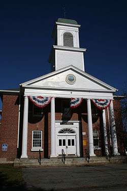
Leicester Town Hall | ||
| ||
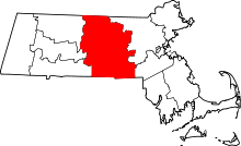
 Location in Worcester County and the state of Massachusetts. | ||
| Coordinates: 42°14′45″N 71°54′33″W / 42.24583°N 71.90917°WCoordinates: 42°14′45″N 71°54′33″W / 42.24583°N 71.90917°W | ||
| Country | United States | |
| State | Massachusetts | |
| County | Worcester | |
| Settled | 1713 | |
| Incorporated | 1714 | |
| Government | ||
| • Type | Open town meeting | |
| • Town Administrator | Kevin Mizikar | |
| • Board of Selectmen |
Thomas Buckley III (Chair) Dianna Provencher (Vice Chair) Matt Dennison (Second Vice Chair) Doug Belanger Sandy Wilson | |
| • Superintendent of Schools | Judith J. Paolucci | |
| • School Committee |
Scott Francis (Chair) Tyler Keenan (Vice Chair) Deborah LaBombard (Secretary) Paul McCarthy Grover Adams | |
| Area | ||
| • Total | 24.7 sq mi (63.9 km2) | |
| • Land | 23.4 sq mi (60.5 km2) | |
| • Water | 1.3 sq mi (3.4 km2) | |
| Elevation | 1,009 ft (308 m) | |
| Population (2010) | ||
| • Total | 10,970 | |
| • Density | 440/sq mi (170/km2) | |
| Time zone | Eastern (UTC-5) | |
| • Summer (DST) | Eastern (UTC-4) | |
| ZIP code | 01524, 01542, 01611 | |
| Area code(s) | 508 / 774 | |
| FIPS code | 25-34795 | |
| GNIS feature ID | 0619483 | |
| Website | http://www.leicesterma.org/ | |

Leicester /ˈlɛstər/ is a town in Worcester County, Massachusetts, United States. The population was 10,970 at the 2010 census.
History
Leicester was first settled in 1713 and was officially incorporated in 1714. The town was named after Robert Dudley, 1st Earl of Leicester.[1]
One of the early settlers in town was a Dr. Samuel Green. He lived at 2 Charlton St., in Greenville (which is now part of Rochdale, a village in Leicester). Samuel Green lived in a house at 2 Charlton Street. He was a doctor who trained many other doctors in the early 1700s. This constituted the first medical school in Massachusetts. The Green family was involved in the creation of both Worcester's Green Hill Park and New York City's Central Park.
Although no significant battles of the American Revolution were fought in the area, Leicester citizens played a large role in the conflict's start. At a Committee of Safety meeting in 1774, Leicester's Colonel William Henshaw declared that "we must have companies of men ready to march upon a minute's notice"—coining the term "minutemen", a nickname for the militia members who fought in the revolution's first battles. Henshaw would later become an adjutant general to Artemas Ward, who was second in command to George Washington in the Continental Army.
Before the British troops marched to Lexington and Concord, looking for the ammunition and equipment held by the Americans, that ammunition and equipment was moved further West to four locations in the town of Leicester, including the house Dr. Green built at 2 Charlton Street. This information can be found in books held on reserve in the Leicester Public Library. When they heard that the British had attacked, Leicester's own Minutemen gathered on Leicester Common. They marched quickly to join with other Minutemen on April 19, 1775, to fight at the first conflict between Massachusetts residents and British troops, the Battles of Lexington and Concord. A few months later on June 17, 1775, a freed slave and Leicester resident named Peter Salem fought at the Battle of Bunker Hill, where he killed British Major John Pitcairn. Both men are memorialized in Leicester street names (Peter Salem Road, Pitcairn Avenue), as is Colonel Henshaw (Henshaw Street).
General Knox brought cannons from New York through the town of Leicester, delivering them to General Washington at Dorchester Heights. There is a monument near the Leicester Library to mark that route. These cannons caused the British to evacuate their troops from Boston, after they woke up one morning to find cannons facing them from above them.
Leicester also held a leading role in Massachusetts' second great revolution, the coming of industrialization. As early as the 1780s, Leicester's mills churned out one-third of American hand cards, which were tools for straightening fibers before spinning thread and weaving cloth. By the 1890s when Leicester industry began to fade, the town was producing one-third of all hand and machine cards in North America.
Ruth Henshaw Bascom (1772–1848), the wife of Reverend Ezekial Lysander Bascom and daughter of Colonel William Henshaw and Phebe Swan, became America's premier portrait folk artist and pastelist, producing over one thousand portraits from 1789 to 1846.
Eli Whitney, the man who invented the cotton gin and devised the idea of interchangeable parts, went to school at Leicester Academy, which eventually became Leicester High School. Ebenezer Adams, who would later be the first mathematics and natural philosophy professor at the Phillips Exeter Academy in New Hampshire, was the academic preceptor in Leicester in 1792.[2] Leicester's Pliny Earle helped Samuel Slater build the first American mill in Pawtucket, Rhode Island, by building the first carding machine. This began the American Industrial Revolution. Leicester today is one of the most northernmost communities within the Blackstone River Valley, National Heritage Corridor. Its early role with carding machines, and the role that Pliny Earle played with the first water powered mill at Pawtucket, complete the case for inclusion on Leicester in this Federal NPS historic designation.
As with most Massachusetts cities and towns, local history can be found and researched in the local public library. The Leicester Public Library has a rich collection of books and articles connected to Leicester's history. In addition, local cemeteries have graves dating back to the French and Indian War and the American Revolution.
Other social leaders who came from Leicester include Charles Adams, military officer and foreign minister, born in town;[2] Emory Washburn, governor of Massachusetts from 1854–1855; and Samuel May, a pastor and active abolitionist in the 1860s, whose house was a stop on the Underground Railroad. He also served as secretary of the Massachusetts Anti-Slave Society. His house has become a part of the Becker College campus.
In 2005, the Worcester Telegram & Gazette named Leicester one of Central Massachusetts' top ten sports towns.
Geography
According to the United States Census Bureau, the town has a total area of 24.7 square miles (64 km2), of which 23.4 square miles (61 km2) is land and 1.3 square miles (3.4 km2), or 5.35%, is water.
Leicester includes four distinct villages—Leicester Center, Cherry Valley (the east side of town, near Worcester), Rochdale (a crossroads in the southeast corner, near the Oxford line), and Greenville (now considered to be part of Rochdale). Cherry Valley and Rochdale have separate ZIP codes from the rest of the town (01611 and 01542, respectively), but otherwise the village boundaries have no official significance, although some Cherry Valley, Rochdale, and Greenville residents identify more strongly with their village than the town. The village of Greenville is now considered part of Rochdale, as it falls within the 01542 ZIP code; the former villages of Mannville and Lakeside were destroyed to construct the Kettle Brook reservoir system, in northeastern Leicester, to supply water to Worcester.
The town is cut into quarters by two state highways, east-west Route 9 and north-south Route 56. Route 9 is called Main Street through Cherry Valley and most of the rest of town; it follows a bypass alignment called South Main Street around the Washburn Square area. The town is actively trying to encourage business development along the western end of Route 9. Route 56 north of the Leicester Center crossroads is Paxton Street; south, it is Pleasant Street until it detours along a bypass road, Huntoon Memorial Highway, that skirts the edge of Rochdale.
Spencer, now a separate town to the west, was once part of Leicester. Other municipalities bordering Leicester include Paxton along Route 56 to the north, Worcester and Auburn on the east, and Oxford and Charlton on the south. Large parts of both Paxton and Auburn were also once part of Leicester.
The end of Worcester Regional Airport's longest runway, along with much of the airport's property, is in Leicester. Additionally, most of Worcester's Kettle Brook water reservoir system is in Leicester.
Demographics
| Historical population | ||
|---|---|---|
| Year | Pop. | ±% |
| 1850 | 2,269 | — |
| 1860 | 2,748 | +21.1% |
| 1870 | 2,768 | +0.7% |
| 1880 | 2,779 | +0.4% |
| 1890 | 3,120 | +12.3% |
| 1900 | 3,416 | +9.5% |
| 1910 | 3,237 | −5.2% |
| 1920 | 3,635 | +12.3% |
| 1930 | 4,445 | +22.3% |
| 1940 | 4,851 | +9.1% |
| 1950 | 6,029 | +24.3% |
| 1960 | 8,177 | +35.6% |
| 1970 | 9,140 | +11.8% |
| 1980 | 9,446 | +3.3% |
| 1990 | 10,191 | +7.9% |
| 2000 | 10,471 | +2.7% |
| 2010 | 10,970 | +4.8% |
| * = population estimate. Source: United States Census records and Population Estimates Program data.[3][4][5][6][7][8][9][10][11][12] | ||
As of the census[13] of 2000, there were 10,471 people, 3,683 households, and 2,707 families residing in the town. The population density was 448.3 inhabitants per square mile (173.1/km2). There were 3,826 housing units at an average density of 163.8 per square mile (63.2/km2). The racial makeup of the town was 96.29% White, 1.28% African American, 0.31% Native American, 0.74% Asian, 0.06% Pacific Islander, 0.31% from other races, and 1.01% from two or more races. Hispanic or Latino of any race were 1.75% of the population.
There were 3,683 households out of which 35.3% had children under the age of 18 living with them, 59.1% were married couples living together, 10.5% had a female householder with no husband present, and 26.5% were non-families. 21.9% of all households were made up of individuals and 9.3% had someone living alone who was 65 years of age or older. The average household size was 2.73 and the average family size was 3.21.
In the town the population was spread out with 26.0% under the age of 18, 9.2% from 18 to 24, 30.0% from 25 to 44, 22.5% from 45 to 64, and 12.4% who were 65 years of age or older. The median age was 36 years. For every 100 females there were 94.7 males. For every 100 females age 18 and over, there were 90.5 males.
The median income for a household in the town was $55,039, and the median income for a family was $64,202. Males had a median income of $40,991 versus $27,913 for females. The per capita income for the town was $20,822. About 3.2% of families and 4.3% of the population were below the poverty line, including 4.3% of those under age 18 and 5.6% of those age 65 or over.
Government
The Town of Leicester is governed by a five-member Board of Selectmen. This board appoints a town administrator, who is responsible for executive decisions in running the town. They also appoint a Superintendent of Schools, who is responsible for the education department. There is a three-member Board of Health elected by the people of the town, which has separate powers to regulate health matters. These powers are derived directly from Mass General Law chapter 111.
However, more important than all of these boards, are the registered voters of the town. The main power for major decisions in town, especially financial decisions, are all of these registered voters of the town. In an annual town meeting held in the Spring of each year, the budget for the following fiscal year of July 1 through June 30 is determined by the registered voters who attend the meeting. All financial decisions of major importance are made at this meeting, including budget items totaling tens of millions of dollars. There is another town meeting held in the Fall, and other special town meetings can be called for by the selectmen.
This is an example of direct democracy in action. There have been visitors at town meeting from other countries, very interested to see this example of direct democracy in action.
| County-level state agency heads | |
|---|---|
| Clerk of Courts: | Dennis P. McManus (D) |
| District Attorney: | Joseph D. Early, Jr. (D) |
| Register of Deeds: | Anthony J. Vigliotti (D) |
| Register of Probate: | Stephanie K. Fattman (R) |
| County Sheriff: | Lew Evangelidis (R) |
| State government | |
| State Representative(s): | Kate Campanale (R) |
| State Senator(s): | Michael O. Moore (D) |
| Governor's Councilor(s): | Jen Caissie (R) |
| Federal government | |
| U.S. Representative(s): | James P. McGovern (D-2nd District), |
| U.S. Senators: | Elizabeth Warren (D), Ed Markey (D) |
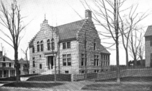
Library
The Leicester public library began in 1801.[14][15] In fiscal year 2008, the town of Leicester spent 0.57% ($145,270) of its budget on its public library—some $13 per person.[16]
Education
Public schools
Public school students in Leicester attend Leicester Primary School (grades K-2), Leicester Memorial School (grades 3-5), Leicester Middle School (grades 6-8) and Leicester High School (grades 9–12). Notable graduates of Leicester High include Diane and Elaine Klimaszewski, better known as the Coors Light Twins.
Higher education
Becker College has a campus on Washburn Square in the heart of Leicester, next to Town Hall. The college's main campus is in Worcester; the Leicester campus was formerly operated independently as Leicester College, one of the older colleges in the country (founded 1782). The two institutions merged under the Becker name in 1997.
References
- ↑ Gannett, Henry (1905). The Origin of Certain Place Names in the United States. U.S. Government Printing Office. p. 184.
- 1 2 Who Was Who in America, Historical Volume, 1607-1896. Chicago: Marquis Who's Who. 1963.
- ↑ "TOTAL POPULATION (P1), 2010 Census Summary File 1". American FactFinder, All County Subdivisions within Massachusetts. United States Census Bureau. 2010.
- ↑ "Massachusetts by Place and County Subdivision - GCT-T1. Population Estimates". United States Census Bureau. Retrieved July 12, 2011.
- ↑ "1990 Census of Population, General Population Characteristics: Massachusetts" (PDF). US Census Bureau. December 1990. Table 76: General Characteristics of Persons, Households, and Families: 1990. 1990 CP-1-23. Retrieved July 12, 2011.
- ↑ "1980 Census of the Population, Number of Inhabitants: Massachusetts" (PDF). US Census Bureau. December 1981. Table 4. Populations of County Subdivisions: 1960 to 1980. PC80-1-A23. Retrieved July 12, 2011.
- ↑ "1950 Census of Population" (PDF). Bureau of the Census. 1952. Section 6, Pages 21-10 and 21-11, Massachusetts Table 6. Population of Counties by Minor Civil Divisions: 1930 to 1950. Retrieved July 12, 2011.
- ↑ "1920 Census of Population" (PDF). Bureau of the Census. Number of Inhabitants, by Counties and Minor Civil Divisions. Pages 21-5 through 21-7. Massachusetts Table 2. Population of Counties by Minor Civil Divisions: 1920, 1910, and 1920. Retrieved July 12, 2011.
- ↑ "1890 Census of the Population" (PDF). Department of the Interior, Census Office. Pages 179 through 182. Massachusetts Table 5. Population of States and Territories by Minor Civil Divisions: 1880 and 1890. Retrieved July 12, 2011.
- ↑ "1870 Census of the Population" (PDF). Department of the Interior, Census Office. 1872. Pages 217 through 220. Table IX. Population of Minor Civil Divisions, &c. Massachusetts. Retrieved July 12, 2011.
- ↑ "1860 Census" (PDF). Department of the Interior, Census Office. 1864. Pages 220 through 226. State of Massachusetts Table No. 3. Populations of Cities, Towns, &c. Retrieved July 12, 2011.
- ↑ "1850 Census" (PDF). Department of the Interior, Census Office. 1854. Pages 338 through 393. Populations of Cities, Towns, &c. Retrieved July 12, 2011.
- ↑ "American FactFinder". United States Census Bureau. Retrieved 2008-01-31.
- ↑ C.B. Tillinghast. The free public libraries of Massachusetts. 1st Report of the Free Public Library Commission of Massachusetts. Boston: Wright & Potter, 1891. Google books
- ↑ http://www.leicesterma.org/government/library.html Retrieved 2010-11-08
- ↑ July 1, 2007 through June 30, 2008; cf. The FY2008 Municipal Pie: What’s Your Share? Commonwealth of Massachusetts, Board of Library Commissioners. Boston: 2009. Available: Municipal Pie Reports. Retrieved 2010-08-04
External links
| Wikimedia Commons has media related to Leicester, Massachusetts. |