Ledegem
| Ledegem | |||
|---|---|---|---|
| Municipality | |||
|
Sint-Eloois-Winkel | |||
| |||
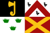
 Ledegem Location in Belgium | |||
|
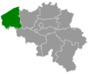
Location of Ledegem in West Flanders  | |||
| Coordinates: 50°51′N 03°07′E / 50.850°N 3.117°ECoordinates: 50°51′N 03°07′E / 50.850°N 3.117°E | |||
| Country | Belgium | ||
| Community | Flemish Community | ||
| Region | Flemish Region | ||
| Province | West Flanders | ||
| Arrondissement | Roeselare | ||
| Government | |||
| • Mayor | Bart Dochy (CD&V) | ||
| • Governing party/ies | sp.a, ACTIEF | ||
| Area | |||
| • Total | 24.76 km2 (9.56 sq mi) | ||
| Population (1 January 2016)[1] | |||
| • Total | 9,530 | ||
| • Density | 380/km2 (1,000/sq mi) | ||
| Postal codes | 8880 | ||
| Area codes | 056 | ||
| Website | www.ledegem.be | ||


Ledegem is a municipality located in the Belgian province of West Flanders. The municipality comprises the towns of Ledegem proper, Rollegem-Kapelle and Sint-Eloois-Winkel. On January 1, 2006, Ledegem had a total population of 9,306. The total area is 24.76 km² which gives a population density of 376 inhabitants per km².
Hulde aan onze Helden is a monument/plaque at the Sint-Petruskerk to the Belgian soldiers and civilians from Ledegem who died in World War I.
References
- ↑ Population per municipality as of 1 January 2016 (XLS; 397 KB)
External links
-
 Media related to Ledegem at Wikimedia Commons
 - Official website (Dutch)
 |
Roeselare | Izegem | | |
| Moorslede | |
Lendelede | ||
| ||||
| | ||||
| Wevelgem | Kortrijk |
This article is issued from Wikipedia - version of the 12/1/2016. The text is available under the Creative Commons Attribution/Share Alike but additional terms may apply for the media files.