Le Pertuis
| Le Pertuis | |
|---|---|
|
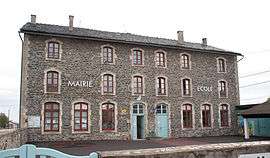
The town hall in Le Pertuis | |
 Le Pertuis | |
|
Location within Auvergne-Rhône-Alpes region  Le Pertuis | |
| Coordinates: 45°05′50″N 4°03′35″E / 45.0972°N 4.0597°ECoordinates: 45°05′50″N 4°03′35″E / 45.0972°N 4.0597°E | |
| Country | France |
| Region | Auvergne-Rhône-Alpes |
| Department | Haute-Loire |
| Arrondissement | Le Puy-en-Velay |
| Canton | Saint-Julien-Chapteuil |
| Government | |
| • Mayor | Pierre Darne |
| Area1 | 11.89 km2 (4.59 sq mi) |
| Population (1999)2 | 375 |
| • Density | 32/km2 (82/sq mi) |
| Time zone | CET (UTC+1) |
| • Summer (DST) | CEST (UTC+2) |
| INSEE/Postal code | 43150 / 43200 |
| Elevation |
879–1,255 m (2,884–4,117 ft) (avg. 1,026 m or 3,366 ft) |
|
1 French Land Register data, which excludes lakes, ponds, glaciers > 1 km² (0.386 sq mi or 247 acres) and river estuaries. 2 Population without double counting: residents of multiple communes (e.g., students and military personnel) only counted once. | |
Le Pertuis is a commune in the Haute-Loire department in south-central France.
See also
| Wikimedia Commons has media related to Le Pertuis. |
This article is issued from Wikipedia - version of the 2/11/2015. The text is available under the Creative Commons Attribution/Share Alike but additional terms may apply for the media files.