Le Cloître-Pleyben
| Le Cloître-Pleyben Kloastr-Pleiben | |
|---|---|
|
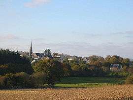
A general view of Le Cloître-Pleyben | |
 Le Cloître-Pleyben | |
|
Location within Brittany region  Le Cloître-Pleyben | |
| Coordinates: 48°15′28″N 3°53′21″W / 48.2578°N 3.8892°WCoordinates: 48°15′28″N 3°53′21″W / 48.2578°N 3.8892°W | |
| Country | France |
| Region | Brittany |
| Department | Finistère |
| Arrondissement | Châteaulin |
| Canton | Pleyben |
| Intercommunality | Région de Pleyben |
| Government | |
| • Mayor (2014–2020) | Dominique Bilirit |
| Area1 | 20.42 km2 (7.88 sq mi) |
| Population (2008)2 | 572 |
| • Density | 28/km2 (73/sq mi) |
| Time zone | CET (UTC+1) |
| • Summer (DST) | CEST (UTC+2) |
| INSEE/Postal code | 29033 / 29190 |
| Elevation | 65–167 m (213–548 ft) |
|
1 French Land Register data, which excludes lakes, ponds, glaciers > 1 km² (0.386 sq mi or 247 acres) and river estuaries. 2 Population without double counting: residents of multiple communes (e.g., students and military personnel) only counted once. | |
Le Cloître-Pleyben (Breton: Kloastr-Pleiben) is a commune in the Finistère department of Brittany in north-western France.
Population
Inhabitants of Le Cloître-Pleyben are called in French Cloîtriens.
| Historical population | ||
|---|---|---|
| Year | Pop. | ±% |
| 1793 | 837 | — |
| 1800 | 883 | +5.5% |
| 1806 | 862 | −2.4% |
| 1821 | 899 | +4.3% |
| 1831 | 950 | +5.7% |
| 1836 | 984 | +3.6% |
| 1841 | 1,027 | +4.4% |
| 1846 | 1,087 | +5.8% |
| 1851 | 1,098 | +1.0% |
| 1856 | 1,115 | +1.5% |
| 1861 | 1,087 | −2.5% |
| 1866 | 1,102 | +1.4% |
| 1872 | 1,114 | +1.1% |
| 1876 | 1,269 | +13.9% |
| 1881 | 1,246 | −1.8% |
| 1886 | 1,303 | +4.6% |
| 1891 | 1,356 | +4.1% |
| 1896 | 1,396 | +2.9% |
| 1901 | 1,426 | +2.1% |
| 1906 | 1,513 | +6.1% |
| 1911 | 1,479 | −2.2% |
| 1921 | 1,360 | −8.0% |
| 1926 | 1,307 | −3.9% |
| 1931 | 1,278 | −2.2% |
| 1936 | 1,139 | −10.9% |
| 1946 | 1,147 | +0.7% |
| 1954 | 1,043 | −9.1% |
| 1962 | 881 | −15.5% |
| 1968 | 791 | −10.2% |
| 1975 | 673 | −14.9% |
| 1982 | 588 | −12.6% |
| 1990 | 512 | −12.9% |
| 1999 | 536 | +4.7% |
| 2008 | 572 | +6.7% |
See also
References
- Mayors of Finistère Association (French);
External links
| Wikimedia Commons has media related to Le Cloître-Pleyben. |
This article is issued from Wikipedia - version of the 2/23/2015. The text is available under the Creative Commons Attribution/Share Alike but additional terms may apply for the media files.