Le Béage
| Le Béage | |
|---|---|
 Le Béage | |
|
Location within Auvergne-Rhône-Alpes region  Le Béage | |
| Coordinates: 44°51′00″N 4°07′11″E / 44.85°N 4.1197°ECoordinates: 44°51′00″N 4°07′11″E / 44.85°N 4.1197°E | |
| Country | France |
| Region | Auvergne-Rhône-Alpes |
| Department | Ardèche |
| Arrondissement | Largentière |
| Canton | Montpezat-sous-Bauzon |
| Intercommunality | Community of communes Source de la Loire |
| Government | |
| • Mayor (2008–2014) | Jean-Marie Redon |
| Area1 | 32.83 km2 (12.68 sq mi) |
| Population (2012)2 | 285 |
| • Density | 8.7/km2 (22/sq mi) |
| Time zone | CET (UTC+1) |
| • Summer (DST) | CEST (UTC+2) |
| INSEE/Postal code | 07026 / 07630 |
| Elevation |
960–1,602 m (3,150–5,256 ft) (avg. 1,200 m or 3,900 ft) |
|
1 French Land Register data, which excludes lakes, ponds, glaciers > 1 km² (0.386 sq mi or 247 acres) and river estuaries. 2 Population without double counting: residents of multiple communes (e.g., students and military personnel) only counted once. | |
Le Béage is a French commune in the Ardèche department in the Auvergne-Rhône-Alpes region of southern France.[1]
The inhabitants of the commune are known as Béageais or Béageaises.[2]
Geography
Le Béage is located some 30 km south-east of Le Puy-en-Velay and 30 km north-west of Aubenas. The northern border of the commune is the departmental border with Haute-Loire. Access to the commune is by the D16 road from Le Lac-d'Issarlès in the south-west which goes to the village. The D122 comes from Sainte-Eulalie in the south-east which passes through the village and continues north-west, changing to the D535 at the departmental border, and continuing to Freycenet-la-Cuche. The D302 goes south to Cros-de-Géorand while the D377 goes north-east changing to the D378A in the commune then to the D36 at the departmental border and continues to Les Estables in the north. The D378 branches from the D377 in the north of the commune and goes to Borée in the north-east. Apart from the village there are the hamlets of Mazaboulet, Beauregard, Chanalettes, and Touzieres. The commune has large forests with farmland.[3][4]
The Veyradeyre rises in the north-east of the commune and flows west then south-west through the commune gathering many tributaries in the commune as it continues south to join the Loire west of Le Lac-d'Issarles. The Gage river rises in the east of the commune and flows south forming most of the eastern border then continues to join the Tauron south of the commune. The Orcival forms part of the northern border as it flows west, forming the departmental border, to join the Loire west of Issarlès.[3][4]
Mapping
A list of online mapping systems can be displayed by clicking on the coordinates (latitude and longitude) in the top right hand corner of this article.
Neighbouring communes and villages
 |
Freycenet-la-Cuche | Les Estables | Borée | |
| Issarlès | |
Le Chambon | ||
| ||||
| | ||||
| Le Lac-d'Issarlès | Cros-de-Géorand | Sainte-Eulalie |
Toponymy
Le Béage appears as le Beage on the 1750 Cassini Map[5] and the same on the 1790 version.[6]
History
The origins and name of the commune appear to be linked to the old road that passes through it. Montpezat-sous-Bauzon in Monastier has a very old road coming from the Rhone valley called Chemin du Pal. Julius Caesar would have passed near the village (or even through) on his way to face the Arverni with his legions. He would have been forced to make a great effort to shift the snow that was blocking him. Located at a halfway point, Le Béage experienced a renowned trade because this village was a relay point for mules and other carters who were halfway to Puy-en-Velay. There were many inns. After the French Revolution royalists were still very numerous in the area and troops from Puy-en-Velay came to reinforce the local forces to maintain order.
Many fairs and markets drew large crowds to Le Béage where most inhabitants were at the same time farmers, traders, freight carriers, and often owners of public houses. There were still more than 30 in the 1940s. In the 1830s the population was about 2400 inhabitants which dropped to 1550 by the 1900s and the number of inhabitants is now 285. This trade suggests that the origins of Le Béage date far back in time as for some names: "Chazales", de Casa, Casals. The houses: "Crouste", caves, underground houses, and "Chabanis" for huts bear witness to ancient settlements. It was certainly the grouping of inhabitants at a crossroads that gave birth to the village of Le Béage.
The etymology and origins of Béage come from th French Le Béage or Lou Biadge in loacl dialect. The current name "Le Béage" dates back to the French Revolution, in the 1790s, a time when Le Béage was created as a commune. There are several hypotheses on the origin of the name: it may have simply come from Le Péage (The Toll) but the most probable hypothesis refers to the ancient road that divides the interior of the village and Le Béage "Bizadge" (old dialect) or "Lou biadgé" (recent dialect) would mean a village with two paths which agrees quite well with the ancient trade Béage. The village is also known as the Bisatico and Bidagiis (Latin).
The 2000s have seen the construction of housing estates, a community hall, and a fire station. The old village was also repaved. According to Regis Sahuc the village is also called "Arvermaténia" which would have meant "door of the Auvergne" or "Arverni", the Gallic tribes inhabiting the Auvergne.
Administration
| From | To | Name |
|---|---|---|
| 1801 | 1801 | Antoine Théofrède Chouvet |
| 1801 | 1802 | Jean Louis Gimbert |
| 1802 | 1825 | Antoine Saugues |
| 1825 | 1828 | François Talobre |
| 1828 | 1830 | Jean Louis Ollier |
| 1830 | 1834 | Jean Jacques Gimbert |
| 1834 | 1836 | Louis Testud |
| 1836 | 1854 | Jean Louis Ollier |
| 1854 | 1860 | Jean Antoine Souteyran |
| 1870 | 1871 | Adolphe Lourdin |
| 1871 | 1879 | Cyprien Souteyran |
| 1880 | 1886 | Rosières Saugues |
| 1886 | 1888 | Jean Louis Petit |
| 1888 | 1889 | Cyprien Souteyran |
| 1889 | 1901 | Cyprien, Clovis, Amédée, Léonard Souteyran |
| 1901 | 1902 | Pierre Teyssier |
| 1902 | 1929 | Cyprien, Clovis, Amédée, Léonard Souteyran |
- Mayors from 1959
| From | To | Name | Party | Position |
|---|---|---|---|---|
| 1959 | 1971 | Edmond Jalade | ||
| 1971 | 1989 | Marcel Gardes | ||
| 1989 | 1995 | Jean Lavastre | ||
| 1995 | 2020 | Jean-Marie Redon |
(Not all data is known)
Demography
In 2012 the commune had 285 inhabitants. The evolution of the number of inhabitants is known from the population censuses conducted in the commune since 1793. From the 21st century, a census of communes with fewer than 10,000 inhabitants is held every five years, unlike larger communes that have a sample survey every year.[Note 1]
| 1793 | 1800 | 1806 | 1821 | 1831 | 1836 | 1841 | 1846 | 1851 |
|---|---|---|---|---|---|---|---|---|
| 1,280 | 1,338 | 1,369 | 1,618 | 2,406 | 1,794 | 1,731 | 1,752 | 1,756 |
| 1856 | 1861 | 1866 | 1872 | 1876 | 1881 | 1886 | 1891 | 1896 |
|---|---|---|---|---|---|---|---|---|
| 1,712 | 1,743 | 1,725 | 1,614 | 1,648 | 1,602 | 1,575 | 1,512 | 1,530 |
| 1901 | 1906 | 1911 | 1921 | 1926 | 1931 | 1936 | 1946 | 1954 |
|---|---|---|---|---|---|---|---|---|
| 1,562 | 1,530 | 1,408 | 1,302 | 1,201 | 1,131 | 1,056 | 928 | 827 |
| 1962 | 1968 | 1975 | 1982 | 1990 | 1999 | 2007 | 2012 | - |
|---|---|---|---|---|---|---|---|---|
| 671 | 640 | 531 | 436 | 352 | 337 | 328 | 285 | - |
Sources : Ldh/EHESS/Cassini until 1962, INSEE database from 1968 (population without double counting and municipal population from 2006)

Education
The commune has a public primary school.[8]
Culture and heritage
Civil heritage
- The Chartreuse de Bonnefoy ruins reveal the "high house" and "low house".
- The Chastelas Chateau ruins
Religious heritage
- The Presbytery contains a number of items that are registered as historical objects:
- The Church of Saint Peter contains a number of items that are registered as historical objects:
- A Processional Cross (16th century)
 [14]
[14] - A Bronze Bell (1661)[15]
- A Window representing Saint John Francis Regis (19th century)[16]
- An Altar: The Virgin (19th century)[17]
- An Altar: Saint John Francis Regis (19th century)[18]
- A Confessional (19th century)[19]
- A Statue with base: Saint Peter (19th century)[20]
- A Statue: Saint Joseph and child (19th century)[21]
- A Baptismal font (18th century)[22]
- A Canopied Altar (19th century)[23]
- A Processional Cross (16th century)
Associations
- Festival Committee
- Association Sportive du Béage (Football, Senior team Drôme-Ardèche second division)
- Youth Committee of Béage
- Autumn Sun
- Association of Grands Plateaux
Events
- The Grasse Fair (Grass-Fed Cattle Competition) takes place every year, three weeks before Easter.
- The Maôche Evening (traditional specialty: Pork belly stuffed with cabbage and sausage meat) held every year on the weekend of 11 November.
- Garage sales are held each year on the last Saturday in July.
- The Village Festival of Béage are held annually on the last Sunday of July.
- The Salon 4x4 Béage is held every year on the last weekend in May.
Culinary specialties
- Maôche ("Maucha" in Occitan is pronounced [mauSo]), pork belly stuffed with sausage meat and cabbage and well cooked in water.
- Bombine is composed of potatoes with carrots, onions, bacon bits (or lamb or calf's foot ...) and flavoured with bay leaf.
- Pogne is a bun shaped like a crown made from flour, eggs, and butter and flavoured with orange blossom.
 Maôche
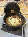 Bombine
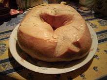 Pogne
Pogne
Notable people linked to the commune
- Captain Jean Antoine Souteyran (16 May 1785 - 27 April 1864, son of Victor Souteyran and Isabeau Giraud). An officer in Napoleon's army, first eagle carrier of the 64th infantry of the line in November 1813, Flag Lieutenant of the 60th Infantry Regiment on 9 August 1814, Knight of the Legion of Honour (1831), Saint Helena Medal (1857). Battle of Jena–Auerstedt, Prantzlow-Eylau, Battle of Friedland, Siege of Lleida (1810), Valencia-Terragone, Villafranca de Panades, Battle of Waterloo. Married to Rose Faure. Former mayor of Béage (1854-1860). His grave is visible today in the cemetery of Béage.
- 'Régis Breysse, born in Béage 19 July 1810, son of Jean Louis Breysse and Rose Chamard. He died at Bicetre on 1 July 1860. Sculptor. The sculptor David d'Angers opened the doors of his studio for him. School of Fine Arts. "Christ on the Cross" in the Aubenas church, "Boissy d'Anglas chairing the meeting of the 1st Prairial" in the Council audience room in the prefecture of Privas.
- Gérenton du Béage (Jarento de Bisatico), Lord of Béage died before the walls of Jerusalem during the Crusades.
See also
Notes and references
Notes
- ↑ At the beginning of the 21st century, the methods of identification have been modified by Law No. 2002-276 of 27 February 2002, the so-called "law of local democracy" and in particular Title V "census operations" allows, after a transitional period running from 2004 to 2008, the annual publication of the legal population of the different French administrative districts. For communes with a population greater than 10,000 inhabitants, a sample survey is conducted annually and the entire territory of these communes is taken into account at the end of the period of five years. The first "legal population" after 1999 under this new law came into force on 1 January 2009 and was based on the census of 2006.
References
- ↑ Le Béage on Lion1906
- ↑ Inhabitants of Ardèche (French)
- 1 2 3 Le Béage on Google Maps
- 1 2 Le Béage on the Géoportail from National Geographic Institute (IGN) website (French)
- ↑ le Beage on the 1750 Cassini Map
- ↑ le Beage on the 1790 Cassini Map
- ↑ List of Mayors of France (French)
- ↑ Schools in Le Béage (French)
- ↑ Ministry of Culture, Palissy PM07001351 Reliquary of Saint John Francis Regis (French)
- ↑ Ministry of Culture, Palissy PM07001350 Monstrance (French)
- ↑ Ministry of Culture, Palissy PM07001349 Statue: The Virgin (French)
- ↑ Ministry of Culture, Palissy PM07001348 Processional Cross (French)
- ↑ Ministry of Culture, Palissy PM07001347 Statue: Saint John Francis Regis (French)
- ↑ Ministry of Culture, Palissy PM07000067 Processional Cross
 (French)
 - ↑ Ministry of Culture, Palissy PM07000066 Bronze Bell (French)
- ↑ Ministry of Culture, Palissy PM07001346 Window representing Saint John Francis Regis (French)
- ↑ Ministry of Culture, Palissy PM07001345 Altar: The Virgin (French)
- ↑ Ministry of Culture, Palissy PM07001344 Altar: Saint John Francis Regis (French)
- ↑ Ministry of Culture, Palissy PM07000522 Confessional (French)
- ↑ Ministry of Culture, Palissy PM07000521 Statue with base: Saint Peter (French)
- ↑ Ministry of Culture, Palissy PM07000520 Statue: Saint Joseph with child (French)
- ↑ Ministry of Culture, Palissy PM07000519 Baptismal font (French)
- ↑ Ministry of Culture, Palissy PM07000518 Canopied Altar (French)
| Wikimedia Commons has media related to Le Béage. |