Latrun
| Latrun | |
|---|---|
|
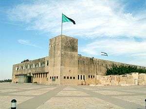
Trappist Monastery | |
 Latrun | |
| Arabic | اللطرون |
| Name meaning | from Latronis[1] |
| Coordinates | 31°50′08″N 34°58′49″E / 31.83556°N 34.98028°ECoordinates: 31°50′08″N 34°58′49″E / 31.83556°N 34.98028°E |
| Palestine grid | 148/137 |

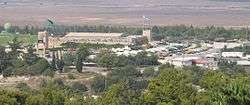
Latrun (Hebrew: לטרון, Latrun; Arabic: اللطرون, al-Latrun) is located at a strategic hilltop in the Latrun salient in the Ayalon Valley. It overlooks the road between Tel-Aviv and Jerusalem, 25 kilometers west of Jerusalem and 14 kilometers southeast of Ramla. It was the site of fierce fighting during the 1948 war. During the 1948–1967 period, it was occupied by Jordan at the edge of a no man's land between the armistice lines known as the Latrun salient. In the 1967 war, it was captured by Israel along with the whole salient and the West Bank, and remains under Israeli occupation.
The hilltop includes Latrun Trappist Monastery, Mini Israel, a park with scale models of historic buildings around Israel, The International Center for the Study of Bird Migration (ICSBM), which is adjacent to Yad La-Shiryon Memorial and Museum. Neve Shalom (Oasis of Peace) is a joint Jewish-Arab community on a hilltop south of Latrun. Canada Park is nearby to the east.
Etymology
The name Latrun is ultimately derived from the ruins of a medieval castle. There are two theories regarding the origin of the name. One is that it is a corruption of the French, Le toron des chevaliers (The Castle of the Knights), named by the Crusaders. The other is that it is from the Latin, Domus boni Latronis (The House of the Good Thief),[2] a name given by 14th century Christian pilgrims after the penitent thief who was crucified by the Romans alongside Jesus (Luke 23:40–43).[3]
History
Biblical era
In the Hebrew Bible, the Ayalon Valley was the site of a battle in which the Israelites, led by Joshua, defeated the Amorites (Joshua 10:1–11).[3] Later, Judah Maccabee established his camp here in preparation for battle with the Seleucid Greeks, who had invaded Israel/Judea and were camped at Emmaus; this site is today identified by archaeologists as Hurvat Eked.[4] According to the Book of Maccabees, Judah Maccabee learned that the Greeks were planning to march on his position, and successfully ambushed the invaders. The Jewish victory in what was later called the Battle of Emmaus led to greater Jewish autonomy under Hasmonean rule over the next century.[5]
Crusader era

Little remains of the castle, which was held by the Templars by 1187. The main tower was later surrounded with a rectangular enclosure with vaulted chambers. This in turn was enclosed by an outer court, of which one tower survives.[6][7][8]
Ottoman era
In 1883, the Palestine Exploration Fund's Survey of Western Palestine (SWP) described Latrun as a few adobe huts among the ruins of a medieval fortress.[9]
In December 1890, a monastery was established at Latrun by French, German and Flemish monks of the Trappists, from Sept-Fons Abbey in France, at the request of Monseigneur Poyet of the Latin Patriarchate of Jerusalem. The monastery is dedicated to Our Lady of the Seven Sorrows. The liturgy is in French. The monks bought the 'Maccabee Hotel', formerly called 'The Howard' from the Batato brothers together with two-hundred hectares of land and started the community in a building which still stands in the monastic domain.[10] In 1909 it was given the status of a Priory and that of an Abbey in 1937.[11] The monks established a vineyard using knowledge gained in France and advice from an expert in the employ of Baron Edmond James de Rothschild from the Carmel-Mizrahi Winery. Today they produce a wide variety of wines that are sold in the Abbey shop and elsewhere.[5]
The community was expelled by the Ottoman Turks between 1914–1918 and the buildings pillaged.
Walid Khalidi in his book All That Remains describes al-Latrun as a small village established in the late 19th century by villagers from nearby Emmaus.
British Mandate
In the 1922 census of Palestine, conducted by the British Mandate authorities, Latrun had a population of 59, all Muslims. In addition, Dair Latrun ("The monastery of Latrun") had a population of 37 Christian males.[12] In the 1931 census they were counted together, and Latrun had a population 120; 76 Muslims and 44 Christians, in a total of 16 houses.[13]
The Latrun monastery was rebuilt in 1926. The crypt was completed in 1933 and the church in 1954. The monastery was designed by the community's first abbot, Dom Paul Couvreur, and is an example of Cistercian architecture. Much of the stained-glass windows were produced by a monk of the community.
A Juniorate, a school for young boys, ran from 1931 until 1963 and provided many vocations for the community, especially of Lebanese monks.[11]
Following the 1936–39 Arab revolt, the British authorities built a number of police forts (named Tegart forts after their designer[14]) at various locations; Latrun was chosen due to its strategic significance, particularly its dominant position above the Tel-Aviv-Jerusalem road. Many members of the Yishuv who had resisted the British administration were imprisoned in a detention camp at Latrun. Moshe Sharett, later Israel's second Prime Minister, and several other members of the Jewish Agency's Executive Committee, were held at Latrun for several months in 1946.[15][16][17]
As of 1945 the population of the Latrun village had grown to 190, with a total of 8,376 dunams of land.[18] Of this, a total of 6,705 dunams were used for cereals, 439 dunams were irrigated or used for orchards, 7 for citrus and bananas,[19] while 4 dunams were classified as built-up public areas.[20]
1948 and 1967 Arab–Israeli Wars

The road from the coastal plain to Jerusalem was blocked after the British withdrew and handed the fort of Latrun over to Jordan's Arab Legion. The Arab Legionnaires used the fort to shell Israeli vehicles traveling on the road below, effectively imposing a military siege on Jerusalem and the Jewish residents there, despite that the United Nations plan was to keep Jerusalem as an international zone with neither Jordan, Israel, nor the Palestinian Arab Higher Committee having sovereignty over it.[21]
On 24 May 1948, ten days after the Israeli Declaration of Independence per the United Nations General Assembly's Resolution 181[22] and the Arab assaults against Israel which followed, the Jordanian Legion's fort was assaulted by combined forces of Israel's newly created 7th Armored Brigade, and a battalion of the Alexandroni Brigade. Ariel Sharon, then a platoon commander, was wounded at Latrun along with many of his soldiers. The assault, codenamed Operation Bin Nun Alef (24–25 May), was unsuccessful, sustaining heavy casualties. On 1 June 1948, a second attack against the fort, codenamed Operation Bin Nun Bet, also failed, although the outer defenses had been breached.
Many of the Israeli fighters were young Holocaust survivors who had just arrived in the country and had minimal military training.[23] The official casualty figure for both battles was 139.
To circumvent the blocked road, a makeshift camouflaged road through the seemingly impassable mountains towards Jerusalem was constructed under the command of Mickey (David) Marcus. This bypassed the main routes overlooked by Latrun and was named the Burma Road after its emergency supply-line namesake between Kumming (China) and Lashio (Burma), improvised by the Allies in World War II. By 10 June 1948, the road was fully operational, putting an end to the month -old Arab blockade.[24]
On 2 August, the Truce Commission drew the attention of the Security Council to the Arabs' refusal to allow water and food supplies to reach Jerusalem. After much negotiation, it was agreed that United Nations convoys would transport supplies, but the convoys often came under sniper fire. Towards the end of August, the situation improved. The destruction of the Latrun pumping station made it impossible for water in adequate quantities to flow to Jerusalem, but the Israelis built an auxiliary water pipe-line of small capacity along the "Burma Road" which provided a minimum amount of water.[25]
After Operation Danny, Israeli forces anticipated a Jordanian counterattack,[26] possibly from Latrun, but King Abdullah remained within the bounds of the tacit agreement made with the Jewish Agency and kept his troops at Latrun.[27]
In the 1949 Armistice Agreements, the fort remained a salient under Jordanian control, which was in turn surrounded by a perimeter of no man's land. Under the cease-fire agreement, Jordan was not to disrupt Israeli travelers using this road; in practice, constant sniper attacks led Israel to build a bypass road around the bulge.
The Palestinian Arab residents of Latrun were evacuated to Imwas in 1949 as a result of the war and Latrun's location on the 1949 armistice line.[28]
In the Six-Day War in 1967, Latrun was captured by the Israeli Defense Forces, and the main-road to Jerusalem was re-opened and made safe for travel. The villages of Imwas, Yalo and Bayt Nuba were razed, their residents taking refuge in the West Bank and Jordan, and Canada Park was established on the land.[29]
Since the Six-Day War
The Latrun monastic community allowed two communities, Neve Shalom/Wahat as-Salam.[30] and the Jesus-Brudershaft[31] to be established on its land The Tegart Fort became the Yad La-Shiryon memorial for fallen soldiers of the Israeli Armored Corps and a Museum was established there.[32]
References
- ↑ Palmer, 1881, p. 322
- ↑ Robinson and Smith, 1841, pp. 30, 66
- 1 2 Walter Pinhas Pick (2007). "Latrun". Encyclopaedia Judaica. Retrieved 2013-10-04.
- ↑ http://www.biblewalks.com/Sites/EmmausFortress.html
- 1 2 Roiter, Nadav (16 September 2011). "Monastic life". The Jerusalem Post. p. 10. Retrieved 3 June 2012.
- ↑ Pringle, 1997, pp. 64-65
- ↑ Pringle, 1998, pp. 5-9
- ↑ Conder and Kitchener, 1883, SWP III, p. 135
- ↑ Conder and Kitchener, 1883, SWP III, pp. 15-16
- ↑ http://pagesperso-orange.fr/augustin.tavardon/ACCUEIL%20HISTOIRE.htm
- 1 2 Latroun Abbey Archive
- ↑ Barron, 1923, Table VII, Sub-district of Ramleh, p. 21
- ↑ Mills, 1932, p. 22.
- ↑ Note that the forts commonly called "Taggart" forts in Israel are named after Sir Charles Tegart - a misspelling apparently from transliteration of the name from English to Hebrew and then back to English.
- ↑ Clifton, Daniel (30 June 1946). "Britain Launches Army Drive to End Palestine Terror". The New York Times. p. 1. Retrieved 3 June 2012.
- ↑ "British to Release 700 Interned Jews". The New York Times. AP. 2 November 1946. p. 4. Retrieved 3 June 2012.
- ↑ "8 Jewish Leaders Freed by British". The New York Times. 6 November 1946. p. 18. Retrieved 3 June 2012.
- ↑ Government of Palestine, Department of Statistics. Village Statistics, April, 1945. Quoted in Hadawi, 1970, p. 67
- ↑ Government of Palestine, Department of Statistics. Village Statistics, April, 1945. Quoted in Hadawi, 1970, p. 116
- ↑ Government of Palestine, Department of Statistics. Village Statistics, April, 1945. Quoted in Hadawi, 1970, p. 166
- ↑ 1948-Israel War of Independence
- ↑ http://daccess-ods.un.org/TMP/712961.703538895.html
- ↑ Lessons of the Battles of Latrun MidEastWeb
- ↑ Morris, 2008, pp. 230–231
- ↑ UN Doc A/648 of 16 September 1948 Progress Report of the United Nations Mediator Count Folke Bernadotte on Palestine Submitted to the Secretary-General for Transmission to the Members of the United Nations.
- ↑ Pappé, 2006, p. 166
- ↑ Pappé, 2006b, p. 140
- ↑ Khalidi, 1992, p. 393
- ↑ Brynen, Rex and Roula El-Rifai. Palestinian Refugees: Challenges of Repatriation and Development. p.128 Ottawa: International Development Research Centre. ISBN 1-55250-231-7
- ↑ Gavron, Daniel (2008). "Living together". Holy Land Mosaic:Stories of Cooperation and Coexistence Between Israelis and Palestinians. Rowman & Littlefield. pp. 57–72. ISBN 978-0-742-54013-2.
- ↑ "Jesus Brotherhood Gnadenthal" (PDF). Retrieved 12 November 2016.
- ↑ "Armored Corps' Memorial Site". Retrieved 12 November 2016.
Bibliography
- Barron, J. B., ed. (1923). Palestine: Report and General Abstracts of the Census of 1922. Government of Palestine.
- Conder, Claude Reignier; Kitchener, H. H. (1883). The Survey of Western Palestine: Memoirs of the Topography, Orography, Hydrography, and Archaeology. 3. London: Committee of the Palestine Exploration Fund.
- Guérin, Victor (1868). Description Géographique Historique et Archéologique de la Palestine (in French). 1: Judee, pt. 1. Paris: L'Imprimerie Nationale. (pp. 59, 309-313)
- Hadawi, Sami (1970). Village Statistics of 1945: A Classification of Land and Area ownership in Palestine. Palestine Liberation Organization Research Center.
- Khalidi, Walid (1992). All That Remains: The Palestinian Villages Occupied and Depopulated by Israel in 1948. Washington D.C.: Institute for Palestine Studies. ISBN 0-88728-224-5.
- Kennedy, Hugh (2000). Crusader Castles. Cambridge University Press. ISBN 0-521-79913-9.
- Mills, E., ed. (1932). Census of Palestine 1931. Population of Villages, Towns and Administrative Areas. Jerusalem: Government of Palestine.
- Morris, Benny (2004). The Birth of the Palestinian Refugee Problem Revisited. Cambridge University Press. ISBN 978-0-521-00967-6.
- Morris, Benny (2008). 1948 : A History of the First Arab-Israeli War. New Haven [Conn.]: Yale University Press. ISBN 0300126964.
- Latrun (2002, ISBN 965-7130-10-7) is a novel by Ram Oren describing the two Battles of Latrun and the events surrounding them.
- Palmer, E. H. (1881). The Survey of Western Palestine: Arabic and English Name Lists Collected During the Survey by Lieutenants Conder and Kitchener, R. E. Transliterated and Explained by E.H. Palmer. Committee of the Palestine Exploration Fund.
- Pappé, Ilan (2006). The Ethnic Cleansing of Palestine. London and New York: Oneworld. ISBN 1-85168-467-0.
- Pappé, Ilan (2006b). The Making of the Arab-Israeli Conflict, 1947-1951. London and New York: I.B. Tauris. ISBN 1-85043-819-6.
- Pringle, Denys (1997). Secular buildings in the Crusader Kingdom of Jerusalem: an archaeological Gazetter. Cambridge University Press. ISBN 0521 46010 7.
- Pringle, Denys (1998). The Churches of the Crusader Kingdom of Jerusalem: L-Z (exluding Tyre). II. Cambridge University Press. ISBN 0 521 39037 0.
- Robinson, Edward; Smith, Eli (1841). Biblical Researches in Palestine, Mount Sinai and Arabia Petraea: A Journal of Travels in the year 1838. 3. Boston: Crocker & Brewster.
External links
| Wikimedia Commons has media related to Latrun. |
- Photo gallery at davidpride.com
- Latrun tanks photo gallery, The gallery of annotated photos of the tanks
- Latrun support armoured vehicles photos
- Latrun monuments, The gallery of annotated photos of the monuments at the Latrun museum dedicated to the fallen soldiers
- Latrun, from the Jewish Agency for Israel
- al-Latrun, from www.palestineremembered.com
- Survey of Western Palestine, Map 17: IAA, Wikimedia commons
- Latrun Battles {reference only}
- 2 Latrun MIAs Identified 1998 {reference only}
- 8 Latrun MIAS Identified 2005 {reference only}
- Abbey History