Latorica
| Latorica, Латориця | |
|---|---|
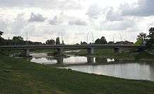 Latorica river near Mukachevo | |
| Country | Ukraine, Slovakia |
| Basin | |
| Main source | Ukraine |
| River mouth |
Bodrog 48°27′17″N 21°49′10″E / 48.4547°N 21.8195°ECoordinates: 48°27′17″N 21°49′10″E / 48.4547°N 21.8195°E |
| Progression | Bodrog→ Tisza→ Danube→ Black Sea |
| Basin size | 3,130 km2 (1,210 sq mi) |
| Physical characteristics | |
| Length | 188 km (117 mi) |
| Discharge |
|
| Features | |
| Tributaries |
|
Latorica (Hungarian: Latorca; Slovak: Latorica, pronounced: Latoritsa; Ukrainian: Латориця, translit.: Latorytsia) is a river in the watershed of the Danube. Its source is in the Ukrainian Carpathians (Eastern Carpathian Mountains), near the village Latorka. It flows from Ukraine (156.6 km) to Slovakia (31.4 km), 188 km in total and west through the towns Svaliava, Mukacheve, Solomonovo, Chop and Velke Kapusany. The watershed is 3,130 km². Its confluence with the Ondava, in Zemplín, gives rise to the Bodrog river, itself a tributary of the Tisza.
A part of its watershed (Latorica Protected Landscape Area, "Ramsar site No. 606", 44.05 km²) was added to the Ramsar list of wetlands of international importance since 1993.
External links
This article is issued from Wikipedia - version of the 6/1/2016. The text is available under the Creative Commons Attribution/Share Alike but additional terms may apply for the media files.