Lashio District
| Lashio | |
|---|---|
| District | |
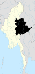
 Lashio Location in Burma | |
| Coordinates: 22°55′00″N 97°44′00″E / 22.91667°N 97.73333°ECoordinates: 22°55′00″N 97°44′00″E / 22.91667°N 97.73333°E | |
| Country |
|
| State | Shan State |
| Elevation[1] | 864 m (2,835 ft) |
| Time zone | MST (UTC+6.30) |
Lashio District (Burmese: လားရှိုးခရိုင်) is a district of Shan State in Myanmar. It consisted of four towns and 2431 villages in 2001.
Townships
The district contains nine townships, including:
- Lashio Township
- Hsenwi Township
- Mongyai Township
- Tangyan Township also spelled as Tangyang Township
- Pangwaun Township also spelled as Panwai Township
- Mongmao Township
- Namphan Township also spelled as Naphan Township
- Pangsang Township
Mongmao, Pangwaun, Namphan and Pangsang (Panhkam) Townships became part of Hopang District and are no longer part of Lashio District since September 2011.[2]
References

This article is issued from Wikipedia - version of the 8/18/2015. The text is available under the Creative Commons Attribution/Share Alike but additional terms may apply for the media files.